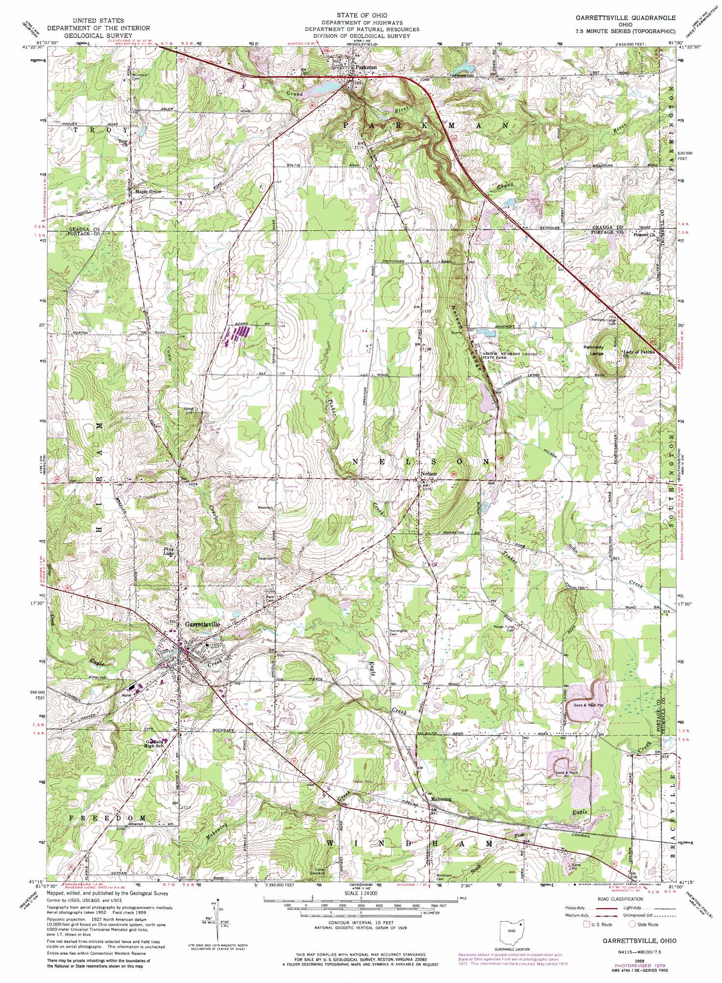
Garrettsville Topo Map Ohio
To zoom in, hover over the map of Garrettsville
USGS Topo Quad 41081c1 - 1:24,000 scale
| Topo Map Name: | Garrettsville |
| USGS Topo Quad ID: | 41081c1 |
| Print Size: | ca. 21 1/4" wide x 27" high |
| Southeast Coordinates: | 41.25° N latitude / 81° W longitude |
| Map Center Coordinates: | 41.3125° N latitude / 81.0625° W longitude |
| U.S. State: | OH |
| Filename: | o41081c1.jpg |
| Download Map JPG Image: | Garrettsville topo map 1:24,000 scale |
| Map Type: | Topographic |
| Topo Series: | 7.5´ |
| Map Scale: | 1:24,000 |
| Source of Map Images: | United States Geological Survey (USGS) |
| Alternate Map Versions: |
Garrettsville OH 1959, updated 1960 Download PDF Buy paper map Garrettsville OH 1959, updated 1971 Download PDF Buy paper map Garrettsville OH 1959, updated 1980 Download PDF Buy paper map Garrettsville OH 1994, updated 1997 Download PDF Buy paper map Garrettsville OH 2010 Download PDF Buy paper map Garrettsville OH 2013 Download PDF Buy paper map Garrettsville OH 2016 Download PDF Buy paper map |
1:24,000 Topo Quads surrounding Garrettsville
Chesterland |
Chardon |
East Claridon |
Windsor |
Orwell |
South Russell |
Burton |
Middlefield |
West Farmington |
Bristolville |
Aurora |
Mantua |
Garrettsville |
Southington |
Champion |
Kent |
Ravenna |
Windham |
Newton Falls |
Warren |
Suffield |
Atwater |
Deerfield |
Lake Milton |
Canfield |
> Back to 41081a1 at 1:100,000 scale
> Back to 41080a1 at 1:250,000 scale
> Back to U.S. Topo Maps home
Garrettsville topo map: Gazetteer
Garrettsville: Airports
Gates Airport elevation 337m 1105′Garrettsville: Benches
Kennedy Ledge elevation 330m 1082′Nelson Ledge elevation 312m 1023′
Newels Ledge elevation 300m 984′
Garrettsville: Canals
Nelson Ditch elevation 280m 918′Garrettsville: Dams
Ohnoname 28 Dam elevation 334m 1095′Owen Pond Dam elevation 299m 980′
Shangri-La Ski Club Dam elevation 324m 1062′
Garrettsville: Falls
Cascade Falls elevation 306m 1003′Minnehaha Falls elevation 297m 974′
Garrettsville: Lakes
Pine Lake elevation 317m 1040′Garrettsville: Mines
Phalanx Quarry elevation 282m 925′South Phalanx Quarry elevation 281m 921′
Garrettsville: Parks
Eagle Creek State Nature Preserve elevation 286m 938′Nelson-Kennedy Ledges State Park elevation 310m 1017′
Garrettsville: Populated Places
Garrettsville elevation 303m 994′Homestead Manor elevation 305m 1000′
Mahoning elevation 290m 951′
Nelson elevation 325m 1066′
P And M Estates elevation 286m 938′
Parkman elevation 332m 1089′
Garrettsville: Post Offices
Garrettsville Post Office elevation 305m 1000′Mahoning Post Office (historical) elevation 289m 948′
Nelson Post Office (historical) elevation 326m 1069′
Parkman Post Office elevation 335m 1099′
Garrettsville: Reservoirs
Moss Beach Club Lake elevation 324m 1062′Ohnoname 28 Reservoir elevation 334m 1095′
Owen Pond elevation 299m 980′
Garrettsville: Streams
Camp Creek elevation 289m 948′Mahoning Creek elevation 282m 925′
Silver Creek elevation 302m 990′
South Fork Eagle Creek elevation 280m 918′
Garrettsville: Trails
Beaver Run Trail elevation 291m 954′Beech Ridge Trail elevation 287m 941′
Clubmoss Trail elevation 295m 967′
Garrettsville: Valleys
Parkman Gorge elevation 277m 908′Garrettsville digital topo map on disk
Buy this Garrettsville topo map showing relief, roads, GPS coordinates and other geographical features, as a high-resolution digital map file on DVD:
 map DVD")