Twinsburg Topo Map Ohio
To zoom in, hover over the map of Twinsburg
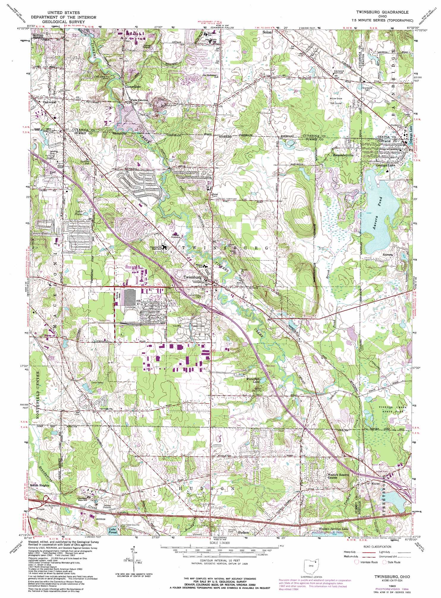
USGS Topo Quad 41081c4 - 1:24,000 scale
| Topo Map Name: | Twinsburg |
| USGS Topo Quad ID: | 41081c4 |
| Print Size: | ca. 21 1/4" wide x 27" high |
| Southeast Coordinates: | 41.25° N latitude / 81.375° W longitude |
| Map Center Coordinates: | 41.3125° N latitude / 81.4375° W longitude |
| U.S. State: | OH |
| Filename: | o41081c4.jpg |
| Download Map JPG Image: | Twinsburg topo map 1:24,000 scale |
| Map Type: | Topographic |
| Topo Series: | 7.5´ |
| Map Scale: | 1:24,000 |
| Source of Map Images: | United States Geological Survey (USGS) |
| Alternate Map Versions: |
Twinsburg OH 1953, updated 1955 Download PDF Buy paper map Twinsburg OH 1963, updated 1964 Download PDF Buy paper map Twinsburg OH 1963, updated 1971 Download PDF Buy paper map Twinsburg OH 1963, updated 1979 Download PDF Buy paper map Twinsburg OH 1963, updated 1985 Download PDF Buy paper map Twinsburg OH 1994, updated 2000 Download PDF Buy paper map Twinsburg OH 2010 Download PDF Buy paper map Twinsburg OH 2013 Download PDF Buy paper map Twinsburg OH 2016 Download PDF Buy paper map |
1:24,000 Topo Quads surrounding Twinsburg
Cleveland North |
East Cleveland |
Mayfield Heights |
Chesterland |
Chardon |
Cleveland South |
Shaker Heights |
Chagrin Falls |
South Russell |
Burton |
Broadview Heights |
Northfield |
Twinsburg |
Aurora |
Mantua |
West Richfield |
Peninsula |
Hudson |
Kent |
Ravenna |
Wadsworth |
Akron West |
Akron East |
Suffield |
Atwater |
> Back to 41081a1 at 1:100,000 scale
> Back to 41080a1 at 1:250,000 scale
> Back to U.S. Topo Maps home
Twinsburg topo map: Gazetteer
Twinsburg: Crossings
Interchange 12 elevation 306m 1003′Twinsburg: Dams
Aurora Pond Dam elevation 304m 997′Lake Forest Dam elevation 305m 1000′
Twinsburg: Lakes
Hudson Springs Lake elevation 313m 1026′Lake Plata elevation 333m 1092′
Waterfall Lake elevation 302m 990′
Twinsburg: Parks
Adams Park elevation 311m 1020′Center Valley Park elevation 296m 971′
Gillie Park elevation 329m 1079′
Glen Chamberlin Park elevation 322m 1056′
Glen Meadow Park elevation 289m 948′
Hudson Springs Park elevation 314m 1030′
Ledges Park elevation 322m 1056′
Mortus Park elevation 332m 1089′
Public Square elevation 303m 994′
Tinkers Creek State Park elevation 306m 1003′
Tinkers Woods Park elevation 289m 948′
Trumbull Woods Park elevation 306m 1003′
Twinsburg: Populated Places
Applecreek Village elevation 319m 1046′Bosworth (historical) elevation 311m 1020′
Falls Junction elevation 290m 951′
Geauga Lake elevation 310m 1017′
Glenwillow elevation 287m 941′
Glenwillow Mobile Home Park elevation 287m 941′
Highland Springs elevation 320m 1049′
Moran elevation 312m 1023′
Reminderville elevation 308m 1010′
Twinsburg elevation 305m 1000′
Western Reserve Estates elevation 326m 1069′
Twinsburg: Post Offices
Geauga Lake Post Office (historical) elevation 311m 1020′Glenwillow Post Office (historical) elevation 286m 938′
Twinsburg Post Office elevation 300m 984′
Twinsburg: Reservoirs
Aurora Pond elevation 304m 997′Lake Forest elevation 305m 1000′
Twinsburg: Streams
Beaver Meadow Run elevation 286m 938′Pond Brook elevation 300m 984′
Twinsburg digital topo map on disk
Buy this Twinsburg topo map showing relief, roads, GPS coordinates and other geographical features, as a high-resolution digital map file on DVD:
 map DVD")