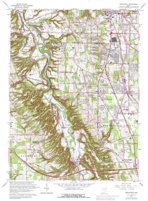
Northfield Topo Map Ohio
To zoom in, hover over the map of Northfield
USGS Topo Quad 41081c5 - 1:24,000 scale
| Topo Map Name: | Northfield |
| USGS Topo Quad ID: | 41081c5 |
| Print Size: | ca. 21 1/4" wide x 27" high |
| Southeast Coordinates: | 41.25° N latitude / 81.5° W longitude |
| Map Center Coordinates: | 41.3125° N latitude / 81.5625° W longitude |
| U.S. State: | OH |
| Filename: | o41081c5.jpg |
| Download Map JPG Image: | Northfield topo map 1:24,000 scale |
| Map Type: | Topographic |
| Topo Series: | 7.5´ |
| Map Scale: | 1:24,000 |
| Source of Map Images: | United States Geological Survey (USGS) |
| Alternate Map Versions: |
Northfield OH 1953, updated 1955 Download PDF Buy paper map Northfield OH 1953, updated 1962 Download PDF Buy paper map Northfield OH 1963, updated 1964 Download PDF Buy paper map Northfield OH 1963, updated 1968 Download PDF Buy paper map Northfield OH 1963, updated 1979 Download PDF Buy paper map Northfield OH 1963, updated 1979 Download PDF Buy paper map Northfield OH 1994, updated 1997 Download PDF Buy paper map Northfield OH 2010 Download PDF Buy paper map Northfield OH 2013 Download PDF Buy paper map Northfield OH 2016 Download PDF Buy paper map |
1:24,000 Topo Quads surrounding Northfield
> Back to 41081a1 at 1:100,000 scale
> Back to 41080a1 at 1:250,000 scale
> Back to U.S. Topo Maps home
Northfield topo map: Gazetteer
Northfield: Airports
Brentwood Ambulatory Care Center Heliport elevation 262m 859′Coliseum Heliport (historical) elevation 342m 1122′
Strattons Heliport elevation 231m 757′
Northfield: Bridges
Brecksville-Northfield High Level Bridge elevation 188m 616′Station Road Bridge elevation 191m 626′
Tinkers Creek Aqueduct elevation 186m 610′
Northfield: Canals
Stumpy Basin elevation 201m 659′Northfield: Crossings
Interchange 11 elevation 355m 1164′Interchange 12 elevation 314m 1030′
Interchange 18 elevation 295m 967′
Interchange 19 elevation 304m 997′
Northfield: Dams
Boston Lock elevation 201m 659′Echo Hills Lake Number One Dam elevation 251m 823′
Northfield: Falls
Blue Hen Falls elevation 245m 803′Brandywine Falls elevation 248m 813′
Bridal Veil Falls elevation 251m 823′
Buttermilk Falls elevation 214m 702′
Northfield: Flats
Chippewa Ford Field elevation 195m 639′Northfield: Lakes
Fell Lake elevation 296m 971′Willow Lake elevation 276m 905′
Northfield: Parks
Brecksville Reservation elevation 244m 800′Dellwood Park elevation 299m 980′
Jaite Mill Historic District elevation 200m 656′
Northfield Park elevation 320m 1049′
Walton Hills Park elevation 277m 908′
Northfield: Populated Places
Alexander elevation 192m 629′Boston elevation 201m 659′
Boston Heights elevation 326m 1069′
Brandywine elevation 257m 843′
Chaffee (historical) elevation 234m 767′
Emmons Corner elevation 301m 987′
Jaite elevation 200m 656′
Ledgewood Mobile Home Park elevation 315m 1033′
Little York elevation 295m 967′
Macedonia elevation 301m 987′
Northfield elevation 320m 1049′
Northfield Center elevation 299m 980′
Oakwood elevation 319m 1046′
Sagamore Hills elevation 259m 849′
Southpark elevation 187m 613′
Walton Hills elevation 302m 990′
Wheelock (historical) elevation 317m 1040′
Northfield: Post Offices
Boston Post Office (historical) elevation 200m 656′Jaite Post Office (historical) elevation 197m 646′
Northfield Post Office elevation 319m 1046′
South Park Post Office (historical) elevation 186m 610′
Northfield: Reservoirs
Echo Hills Lake Number One elevation 251m 823′Northfield: Streams
Brandywine Creek elevation 194m 636′Chippewa Creek elevation 191m 626′
Grannys Run elevation 198m 649′
Indian Creek elevation 292m 958′
Sagamore Run elevation 186m 610′
Stanford Run elevation 197m 646′
Tinkers Creek elevation 186m 610′
Northfield: Woods
Harriet Keeler Memorial Woods elevation 259m 849′Northfield digital topo map on disk
Buy this Northfield topo map showing relief, roads, GPS coordinates and other geographical features, as a high-resolution digital map file on DVD:


