Shaker Heights Topo Map Ohio
To zoom in, hover over the map of Shaker Heights
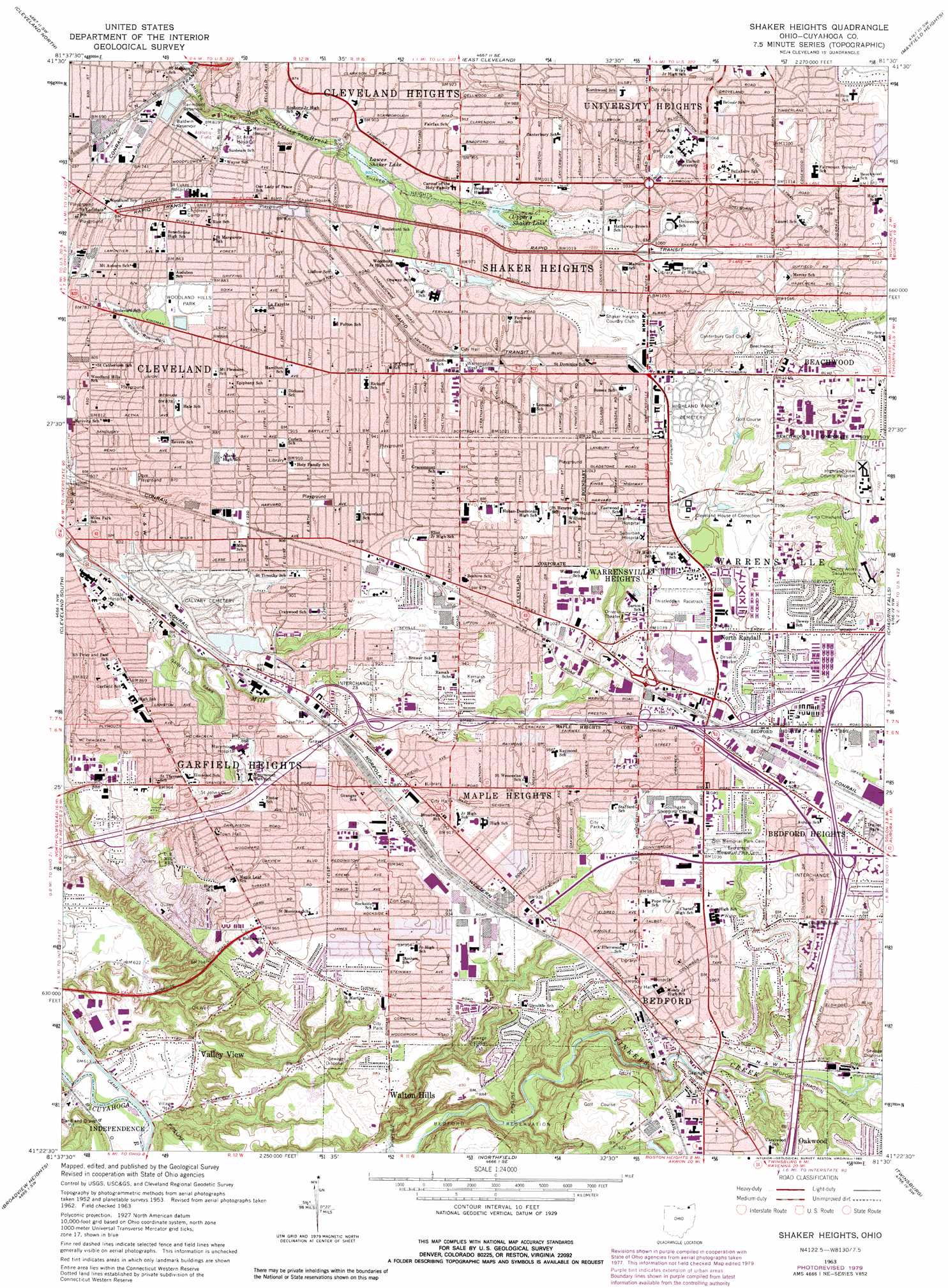
USGS Topo Quad 41081d5 - 1:24,000 scale
| Topo Map Name: | Shaker Heights |
| USGS Topo Quad ID: | 41081d5 |
| Print Size: | ca. 21 1/4" wide x 27" high |
| Southeast Coordinates: | 41.375° N latitude / 81.5° W longitude |
| Map Center Coordinates: | 41.4375° N latitude / 81.5625° W longitude |
| U.S. State: | OH |
| Filename: | o41081d5.jpg |
| Download Map JPG Image: | Shaker Heights topo map 1:24,000 scale |
| Map Type: | Topographic |
| Topo Series: | 7.5´ |
| Map Scale: | 1:24,000 |
| Source of Map Images: | United States Geological Survey (USGS) |
| Alternate Map Versions: |
Shaker Heights OH 1953, updated 1955 Download PDF Buy paper map Shaker Heights OH 1963, updated 1965 Download PDF Buy paper map Shaker Heights OH 1963, updated 1971 Download PDF Buy paper map Shaker Heights OH 1963, updated 1980 Download PDF Buy paper map Shaker Heights OH 1963, updated 1980 Download PDF Buy paper map Shaker Heights OH 1994, updated 2000 Download PDF Buy paper map Shaker Heights OH 2010 Download PDF Buy paper map Shaker Heights OH 2013 Download PDF Buy paper map Shaker Heights OH 2016 Download PDF Buy paper map |
1:24,000 Topo Quads surrounding Shaker Heights
Eastlake |
Mentor |
|||
Cleveland North |
East Cleveland |
Mayfield Heights |
Chesterland |
|
Lakewood |
Cleveland South |
Shaker Heights |
Chagrin Falls |
South Russell |
Berea |
Broadview Heights |
Northfield |
Twinsburg |
Aurora |
Medina |
West Richfield |
Peninsula |
Hudson |
Kent |
> Back to 41081a1 at 1:100,000 scale
> Back to 41080a1 at 1:250,000 scale
> Back to U.S. Topo Maps home
Shaker Heights topo map: Gazetteer
Shaker Heights: Airports
4th District Police Station Heliport elevation 241m 790′Marymount Hospital Heliport elevation 267m 875′
Shaker Heights: Bridges
Commerce Park Plaza elevation 372m 1220′Shaker Heights: Crossings
Interchange 21 elevation 271m 889′Interchange 22 elevation 278m 912′
Interchange 23 elevation 271m 889′
Interchange 24 elevation 271m 889′
Interchange 25 elevation 313m 1026′
Interchange 26 elevation 318m 1043′
Interchange 26 elevation 323m 1059′
Interchange 27 elevation 327m 1072′
Shaker Heights: Dams
Fairmount Upground Reservoir Dam elevation 223m 731′Lower Shaker Lake Dam elevation 273m 895′
Upper Shaker Lake Dam elevation 299m 980′
Shaker Heights: Falls
Great Falls elevation 260m 853′Shaker Heights: Parks
Ambler Heights Historic District elevation 247m 810′Ambler Park elevation 231m 757′
Bedford Metro Reserve elevation 292m 958′
Bedford Reservation elevation 261m 856′
Cuyahoga Valley National Recreation Area elevation 181m 593′
Dove Playground elevation 257m 843′
Dunham Park elevation 263m 862′
Fairhill Road Village Historic District elevation 262m 859′
Fairmount Boulevard Historic District elevation 275m 902′
Garfield Park elevation 256m 839′
Kerruish Park elevation 283m 928′
Kingsbury Run Park elevation 251m 823′
Luna Park (historical) elevation 238m 780′
Miles Park elevation 248m 813′
Miles Park Historic District elevation 286m 938′
Miles Playfield elevation 287m 941′
Schweickert Field elevation 331m 1085′
Shaker Heights Park elevation 287m 941′
Shaker Square elevation 275m 902′
Shaker Square Historic District elevation 275m 902′
Shaker Village Historic District elevation 314m 1030′
Wasmer Field elevation 329m 1079′
Woodland Hills Park elevation 267m 875′
Shaker Heights: Populated Places
Ambler Heights elevation 247m 810′Beachwood elevation 362m 1187′
Bedford elevation 289m 948′
Bedford Heights elevation 317m 1040′
Garfield Heights elevation 291m 954′
Glendale elevation 287m 941′
Henry elevation 250m 820′
Hidden Cove Mobile Home Park elevation 325m 1066′
Highland Hills elevation 334m 1095′
Libby Aurora Mobile Home Park elevation 323m 1059′
Ludlow elevation 284m 931′
Maple Heights elevation 274m 898′
Miles elevation 263m 862′
Mount Pleasant elevation 283m 928′
North Randall elevation 318m 1043′
Randall elevation 320m 1049′
Shaker Heights elevation 320m 1049′
Sorrento elevation 281m 921′
University Heights elevation 313m 1026′
Valley View elevation 196m 643′
Warrensville elevation 327m 1072′
Warrensville Heights elevation 316m 1036′
Woodhill Homes elevation 233m 764′
Shaker Heights: Post Offices
Bedford Post Office (historical) elevation 290m 951′Maple Heights Post Office elevation 280m 918′
Miles Post Office (historical) elevation 265m 869′
North Randall Post Office (historical) elevation 318m 1043′
Shaker Heights Station Cleveland Post Office elevation 275m 902′
Sorrento Post Office (historical) elevation 281m 921′
Warrensville Post Office (historical) elevation 328m 1076′
Shaker Heights: Reservoirs
Baldwin Reservoir elevation 225m 738′Fairmount Reservoir elevation 223m 731′
Green Lake elevation 295m 967′
Kinsman Reservoir elevation 275m 902′
Lower Shaker Lake elevation 273m 895′
Marshall Lake elevation 288m 944′
Shaker Lakes elevation 285m 935′
Upper Shaker Lake elevation 299m 980′
Shaker Heights: Streams
Hawthorne Creek elevation 277m 908′Wood Creek elevation 200m 656′
Shaker Heights digital topo map on disk
Buy this Shaker Heights topo map showing relief, roads, GPS coordinates and other geographical features, as a high-resolution digital map file on DVD:
 map DVD")