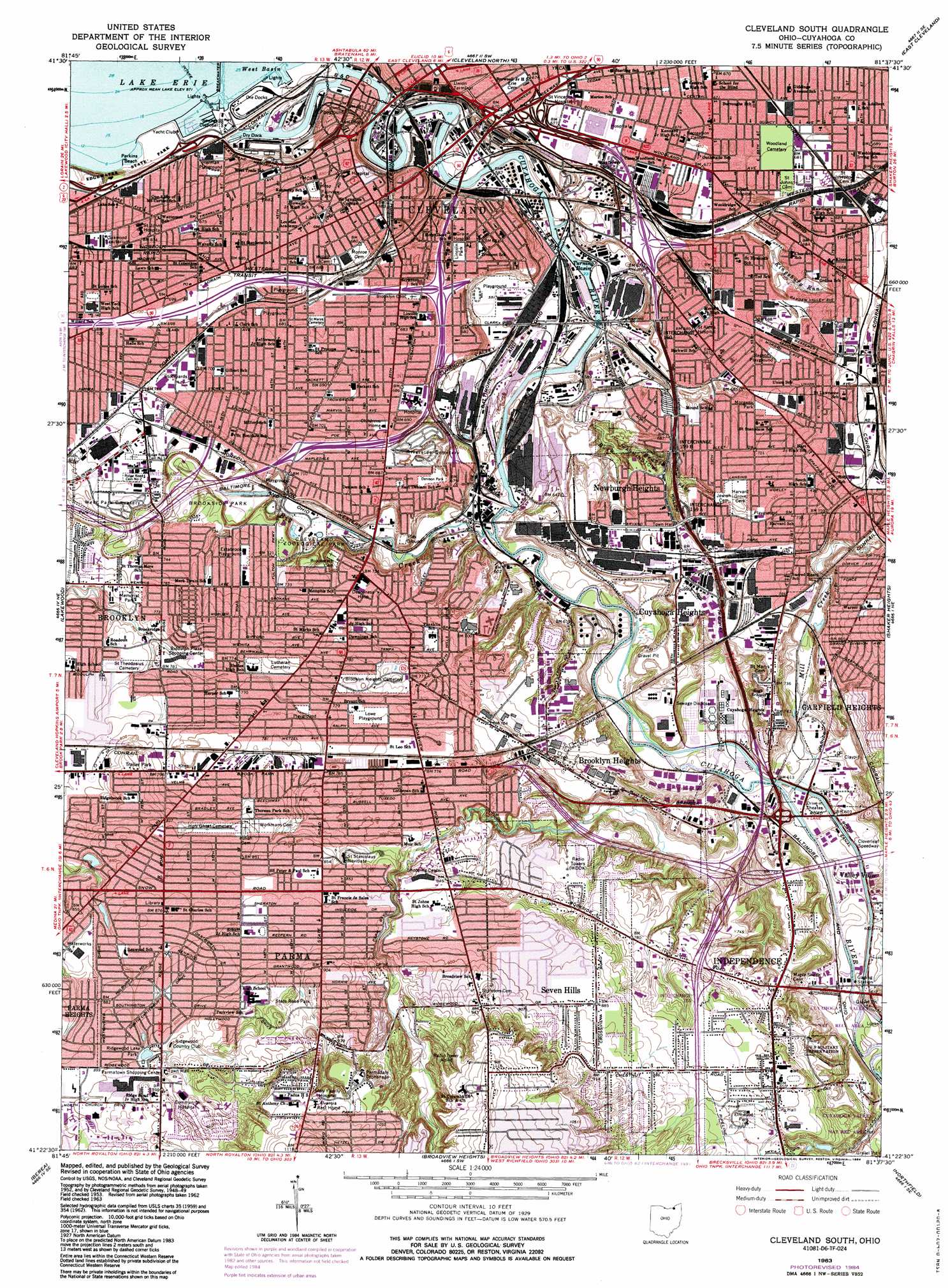
Cleveland South Topo Map Ohio
To zoom in, hover over the map of Cleveland South
USGS Topo Quad 41081d6 - 1:24,000 scale
| Topo Map Name: | Cleveland South |
| USGS Topo Quad ID: | 41081d6 |
| Print Size: | ca. 21 1/4" wide x 27" high |
| Southeast Coordinates: | 41.375° N latitude / 81.625° W longitude |
| Map Center Coordinates: | 41.4375° N latitude / 81.6875° W longitude |
| U.S. State: | OH |
| Filename: | o41081d6.jpg |
| Download Map JPG Image: | Cleveland South topo map 1:24,000 scale |
| Map Type: | Topographic |
| Topo Series: | 7.5´ |
| Map Scale: | 1:24,000 |
| Source of Map Images: | United States Geological Survey (USGS) |
| Alternate Map Versions: |
Cleveland South OH 1953, updated 1955 Download PDF Buy paper map Cleveland South OH 1963, updated 1965 Download PDF Buy paper map Cleveland South OH 1963, updated 1968 Download PDF Buy paper map Cleveland South OH 1963, updated 1971 Download PDF Buy paper map Cleveland South OH 1963, updated 1980 Download PDF Buy paper map Cleveland South OH 1963, updated 1984 Download PDF Buy paper map Cleveland South OH 1963, updated 1984 Download PDF Buy paper map Cleveland South OH 1994, updated 2000 Download PDF Buy paper map Cleveland South OH 2010 Download PDF Buy paper map Cleveland South OH 2013 Download PDF Buy paper map Cleveland South OH 2016 Download PDF Buy paper map |
1:24,000 Topo Quads surrounding Cleveland South
Eastlake |
||||
Cleveland North |
East Cleveland |
Mayfield Heights |
||
North Olmsted |
Lakewood |
Cleveland South |
Shaker Heights |
Chagrin Falls |
West View |
Berea |
Broadview Heights |
Northfield |
Twinsburg |
Mallet Creek |
Medina |
West Richfield |
Peninsula |
Hudson |
> Back to 41081a1 at 1:100,000 scale
> Back to 41080a1 at 1:250,000 scale
> Back to U.S. Topo Maps home
Cleveland South topo map: Gazetteer
Cleveland South: Airports
Cuyahoga County Hospital Heliport elevation 205m 672′Deaconess Hospital Heliport elevation 221m 725′
Lutheran Medical Center Heliport elevation 209m 685′
Parma Community Hospital Heliport elevation 284m 931′
Cleveland South: Beaches
Perkins Beach elevation 174m 570′Cleveland South: Bends
Collision Bend elevation 180m 590′Irishtown Bend elevation 180m 590′
Ox Bow Bend elevation 176m 577′
Cleveland South: Bridges
Central Viaduct (historical) elevation 175m 574′Detroit Superior Viaduct elevation 176m 577′
Fulton Road Bridge elevation 189m 620′
Hope Memorial Bridge elevation 176m 577′
Innerbelt Bridge elevation 175m 574′
Main Avenue Viaduct elevation 175m 574′
Union Terminal Viaduct elevation 175m 574′
West Third Street Bridge elevation 177m 580′
Cleveland South: Channels
Old River elevation 176m 577′Cleveland South: Crossings
Interchange 15 elevation 237m 777′Interchange 155 elevation 235m 770′
Interchange 157 elevation 200m 656′
Interchange 158 elevation 212m 695′
Interchange 159A elevation 209m 685′
Interchange 159B elevation 204m 669′
Interchange 16 elevation 238m 780′
Interchange 160 elevation 207m 679′
Interchange 161A elevation 207m 679′
Interchange 161B elevation 205m 672′
Interchange 167B elevation 214m 702′
Interchange 169 elevation 205m 672′
Interchange 17 elevation 227m 744′
Interchange 170 elevation 207m 679′
Interchange 244 elevation 204m 669′
Interchange 245 elevation 216m 708′
Interchange 246 elevation 209m 685′
Interchange 247 elevation 195m 639′
Cleveland South: Falls
Mill Creek Falls elevation 235m 770′Cleveland South: Flats
The Flats elevation 177m 580′Cleveland South: Harbors
Turning Basin elevation 177m 580′Cleveland South: Islands
Whiskey Island elevation 177m 580′Cleveland South: Parks
Archwood Avenue Historic District elevation 213m 698′Broadway Avenue Historic District elevation 209m 685′
Brookside Park elevation 204m 669′
Byers Field elevation 285m 935′
Calvin Park elevation 307m 1007′
Center Park elevation 315m 1033′
Central Avenue Recreation Center elevation 204m 669′
Clark Recreation Center elevation 210m 688′
Cleveland Zoological Park elevation 195m 639′
Denison Park elevation 206m 675′
East Fourth Street Historic District elevation 202m 662′
Eastbrook Playground elevation 223m 731′
Edgewater State Park elevation 193m 633′
Elmwood Park elevation 258m 846′
Estabrook Playground elevation 223m 731′
F B Fairfax Recreation Center elevation 208m 682′
Fairview Park elevation 210m 688′
Forestwood Park elevation 266m 872′
Franklin Avenue Historic District elevation 207m 679′
Franklin Circle elevation 209m 685′
Gerald Park elevation 263m 862′
Gordon Square Historic District elevation 204m 669′
Grant Playground elevation 205m 672′
Hardware Field (historical) elevation 210m 688′
Henritze Park elevation 221m 725′
Herman Playground elevation 196m 643′
Hetzer Park elevation 344m 1128′
Hollywood Park elevation 284m 931′
John Muir Park elevation 241m 790′
Kentucky Garden elevation 210m 688′
Lexington Green Park elevation 265m 869′
Lincoln Park elevation 207m 679′
Lincoln Recreation Center elevation 206m 675′
Lowe Playground elevation 238m 780′
Market Square elevation 206m 675′
Marlborough Park elevation 253m 830′
Memorial Park elevation 235m 770′
Morgana Park elevation 213m 698′
North Park elevation 238m 780′
Ohio City Preservation District elevation 210m 688′
Plaza At Huron Point elevation 203m 666′
Portland-Outhwaite Recreation Center elevation 207m 679′
Progressive Field elevation 206m 675′
Regency Park elevation 292m 958′
Regent Playground elevation 211m 692′
Ridgewood Lake Park elevation 272m 892′
Soldiers and Sailors Monument elevation 201m 659′
Southpark elevation 263m 862′
State Road Park elevation 283m 928′
Walters Grove Park elevation 256m 839′
Warrior Stadium (historical) elevation 213m 698′
Warszawa Neighborhood Historic District elevation 211m 692′
Washington Park elevation 209m 685′
Cleveland South: Populated Places
Ashbury Towers elevation 207m 679′Big Italy elevation 207m 679′
Broadview Gardens elevation 234m 767′
Brooklyn elevation 233m 764′
Brooklyn Acres elevation 240m 787′
Brooklyn Heights elevation 234m 767′
Cleveland elevation 199m 652′
Cuyahoga Heights elevation 218m 715′
Dutch Alley elevation 209m 685′
Garden Valley elevation 209m 685′
Ideal Mobile Home Park elevation 237m 777′
Karlin elevation 213m 698′
Lakeview Terrace elevation 196m 643′
Little Bohemia elevation 208m 682′
Miller Mobile Homes elevation 225m 738′
Navy Park Housing Project (historical) elevation 223m 731′
Newburgh Heights elevation 211m 692′
Ohio City elevation 209m 685′
Parma elevation 264m 866′
Seven Hills elevation 269m 882′
Slavic Village elevation 213m 698′
South Brooklyn elevation 220m 721′
The Angle elevation 185m 606′
Tremont elevation 204m 669′
Valleyview Homes (historical) elevation 201m 659′
Willow elevation 184m 603′
Cleveland South: Post Offices
Brooklyn Post Office (historical) elevation 232m 761′Ohio City Post Office (historical) elevation 209m 685′
Parma Post Office (historical) elevation 264m 866′
Pearlbrook Station Cleveland Post Office elevation 220m 721′
Station A Cleveland Post Office elevation 210m 688′
Willow Post Office (historical) elevation 184m 603′
Willow Station Cleveland Post Office elevation 210m 688′
Cleveland South: Reservoirs
Kentucky Street Reservoir (historical) elevation 210m 688′Cleveland South: Streams
Big Creek elevation 176m 577′Burk Branch elevation 176m 577′
Kingsbury Run elevation 177m 580′
Mill Creek elevation 179m 587′
Morgan Run elevation 177m 580′
Treadway Creek elevation 176m 577′
West Creek elevation 180m 590′
Cleveland South digital topo map on disk
Buy this Cleveland South topo map showing relief, roads, GPS coordinates and other geographical features, as a high-resolution digital map file on DVD:
 map DVD")