East Cleveland Topo Map Ohio
To zoom in, hover over the map of East Cleveland
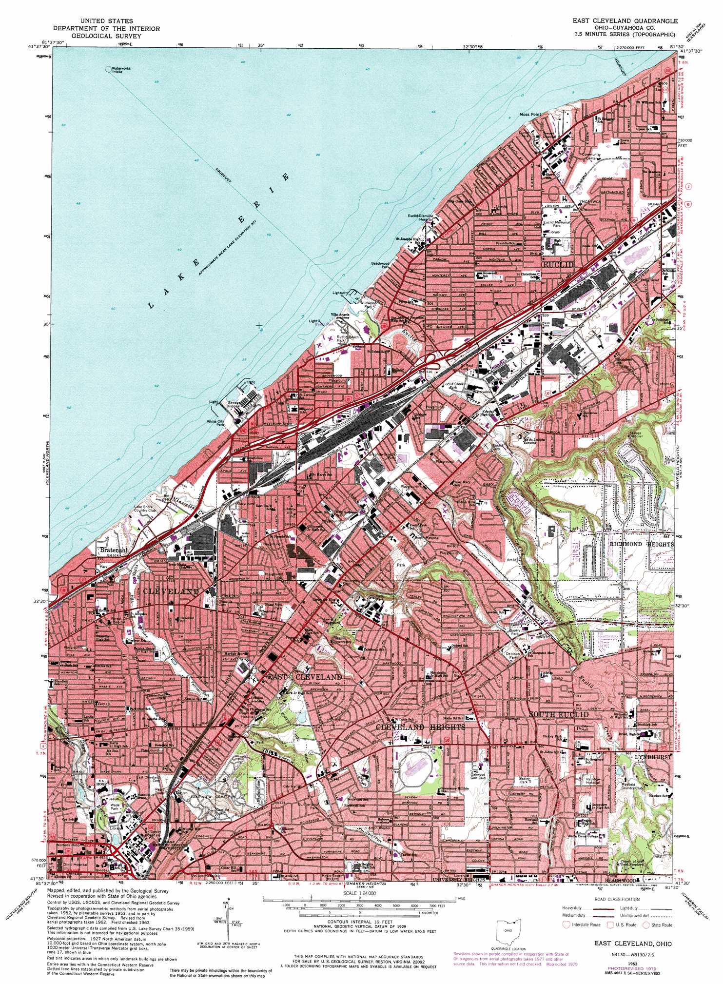
USGS Topo Quad 41081e5 - 1:24,000 scale
| Topo Map Name: | East Cleveland |
| USGS Topo Quad ID: | 41081e5 |
| Print Size: | ca. 21 1/4" wide x 27" high |
| Southeast Coordinates: | 41.5° N latitude / 81.5° W longitude |
| Map Center Coordinates: | 41.5625° N latitude / 81.5625° W longitude |
| U.S. State: | OH |
| Filename: | o41081e5.jpg |
| Download Map JPG Image: | East Cleveland topo map 1:24,000 scale |
| Map Type: | Topographic |
| Topo Series: | 7.5´ |
| Map Scale: | 1:24,000 |
| Source of Map Images: | United States Geological Survey (USGS) |
| Alternate Map Versions: |
East Cleveland OH 1953, updated 1955 Download PDF Buy paper map East Cleveland OH 1963, updated 1964 Download PDF Buy paper map East Cleveland OH 1963, updated 1971 Download PDF Buy paper map East Cleveland OH 1963, updated 1980 Download PDF Buy paper map East Cleveland OH 1994, updated 1997 Download PDF Buy paper map East Cleveland OH 2010 Download PDF Buy paper map East Cleveland OH 2013 Download PDF Buy paper map East Cleveland OH 2016 Download PDF Buy paper map |
1:24,000 Topo Quads surrounding East Cleveland
Eastlake |
Mentor |
|||
Cleveland North |
East Cleveland |
Mayfield Heights |
Chesterland |
|
Lakewood |
Cleveland South |
Shaker Heights |
Chagrin Falls |
South Russell |
Berea |
Broadview Heights |
Northfield |
Twinsburg |
Aurora |
> Back to 41081e1 at 1:100,000 scale
> Back to 41080a1 at 1:250,000 scale
> Back to U.S. Topo Maps home
East Cleveland topo map: Gazetteer
East Cleveland: Airports
Cleveland Clinic Foundation Heliport elevation 205m 672′Cleveland Police Department 6th District Heliport elevation 201m 659′
Meridia Huron Hospital Heliport elevation 218m 715′
Mount Sinai Medical Center Heliport elevation 201m 659′
University Hospitals of Cleveland Heliport elevation 213m 698′
East Cleveland: Cliffs
Moss Point elevation 183m 600′East Cleveland: Crossings
Interchange 178 elevation 189m 620′Interchange 179 elevation 182m 597′
Interchange 180 elevation 185m 606′
Interchange 181 elevation 186m 610′
Interchange 182A elevation 183m 600′
Interchange 182B elevation 189m 620′
Interchange 183 elevation 191m 626′
Interchange 184A elevation 193m 633′
Interchange 184B elevation 194m 636′
East Cleveland: Dams
Forest Hill Park Dam Number Two elevation 234m 767′East Cleveland: Mines
Bluestone Quarries elevation 272m 892′East Cleveland: Parks
Beachwood Park elevation 178m 583′Boxley Park elevation 300m 984′
Cain Park elevation 280m 918′
Cleveland Heights Swimming Pool elevation 266m 872′
Coulter Avenue Park elevation 200m 656′
Cumberland Park elevation 266m 872′
Denison Park elevation 283m 928′
East Eightyninth Street Historic District elevation 203m 666′
Euclid Beach Park elevation 180m 590′
Euclid Creek Park elevation 189m 620′
Euclid Creek Reservation elevation 225m 738′
Euclid Heritage Park elevation 198m 649′
Euclid Memorial Park elevation 188m 616′
Euclid Park elevation 183m 600′
Ferguson Playground elevation 198m 649′
Finnigan Field elevation 210m 688′
Forest Hill Historic District elevation 251m 823′
Forest Hill Park elevation 247m 810′
Forest Hill Parkway elevation 189m 620′
Glenview Park elevation 186m 610′
Graphite-Bronze Park elevation 197m 646′
Hawley Playground elevation 216m 708′
Heritage Park elevation 198m 649′
Magnolia-Wade Park Historic District elevation 202m 662′
Nela Park elevation 242m 793′
Newton Avenue Historic District elevation 205m 672′
Pattison Park elevation 197m 646′
Quarry Park elevation 272m 892′
Robert "Bump" Taylor Field elevation 188m 616′
Rockefeller Park elevation 189m 620′
Shaw Rink Park elevation 200m 656′
Sims Park elevation 182m 597′
Sportsmens Park elevation 198m 649′
Van Horn Field elevation 216m 708′
Wade Park elevation 206m 675′
Wade Park Historic District elevation 206m 675′
White City Amusement Park (historical) elevation 177m 580′
White City Park elevation 176m 577′
Wildwood Park elevation 175m 574′
East Cleveland: Populated Places
Beulah Park elevation 180m 590′Bluestone elevation 266m 872′
Cleveland Heights elevation 285m 935′
Coits elevation 189m 620′
Collamer elevation 207m 679′
Collinwood elevation 192m 629′
Doans Corners elevation 207m 679′
East Cleveland elevation 210m 688′
Euclid elevation 188m 616′
Euclid Beach Mobile Home Park elevation 182m 597′
Euclid Heights elevation 264m 866′
Euclid Homes (historical) elevation 188m 616′
Fairmount elevation 258m 846′
Five Points elevation 193m 633′
Four Points elevation 187m 613′
Glenville elevation 191m 626′
Little Italy elevation 220m 721′
Manhattan Beach elevation 182m 597′
Noble elevation 195m 639′
Nottingham elevation 191m 626′
Richmond Heights elevation 265m 869′
South Euclid elevation 292m 958′
East Cleveland: Post Offices
Beachland Station Cleveland Post Office elevation 185m 606′Bluestone Post Office (historical) elevation 265m 869′
Cleveland Heights Branch Cleveland Post Office elevation 278m 912′
Collinwood Station Cleveland Post Office elevation 191m 626′
Doans Corners Post Office (historical) elevation 207m 679′
Euclid Post Office (historical) elevation 189m 620′
Fairmount Post Office (historical) elevation 259m 849′
Glenville Post Office (historical) elevation 191m 626′
Noble Post Office (historical) elevation 195m 639′
South Euclid Post Office (historical) elevation 291m 954′
Station H Cleveland Post Office elevation 189m 620′
East Cleveland: Reservoirs
Forest Hill Park Reservoir Number Two elevation 234m 767′Lake View Cemetery Flood Control Reservoir elevation 234m 767′
Wade Lagoon elevation 199m 652′
East Cleveland: Streams
Claribel Creek elevation 217m 711′East Branch of Euclid Creek elevation 198m 649′
Euclid Creek elevation 177m 580′
Ninemile Creek elevation 176m 577′
Redstone Run elevation 215m 705′
Stevenson Brook elevation 213m 698′
Verbsky Creek elevation 200m 656′
East Cleveland digital topo map on disk
Buy this East Cleveland topo map showing relief, roads, GPS coordinates and other geographical features, as a high-resolution digital map file on DVD:
 map DVD")