Thompson Topo Map Ohio
To zoom in, hover over the map of Thompson
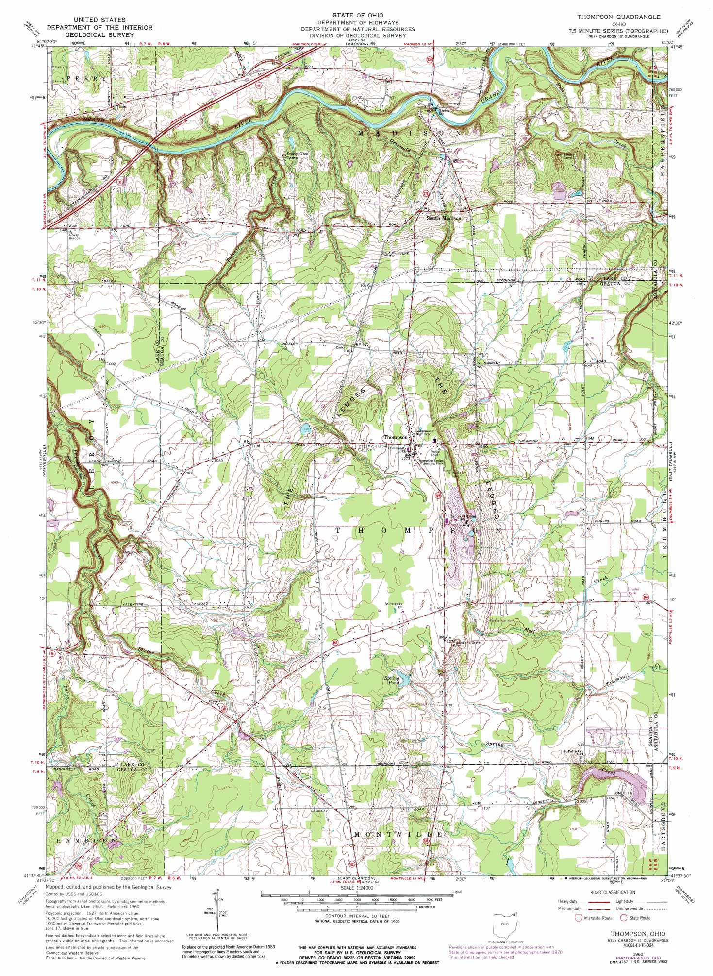
USGS Topo Quad 41081f1 - 1:24,000 scale
| Topo Map Name: | Thompson |
| USGS Topo Quad ID: | 41081f1 |
| Print Size: | ca. 21 1/4" wide x 27" high |
| Southeast Coordinates: | 41.625° N latitude / 81° W longitude |
| Map Center Coordinates: | 41.6875° N latitude / 81.0625° W longitude |
| U.S. State: | OH |
| Filename: | o41081f1.jpg |
| Download Map JPG Image: | Thompson topo map 1:24,000 scale |
| Map Type: | Topographic |
| Topo Series: | 7.5´ |
| Map Scale: | 1:24,000 |
| Source of Map Images: | United States Geological Survey (USGS) |
| Alternate Map Versions: |
Thompson OH 1960, updated 1961 Download PDF Buy paper map Thompson OH 1960, updated 1968 Download PDF Buy paper map Thompson OH 1960, updated 1971 Download PDF Buy paper map Thompson OH 1960, updated 1989 Download PDF Buy paper map Thompson OH 1994, updated 1997 Download PDF Buy paper map Thompson OH 2010 Download PDF Buy paper map Thompson OH 2013 Download PDF Buy paper map Thompson OH 2016 Download PDF Buy paper map |
1:24,000 Topo Quads surrounding Thompson
Ashtabula North |
||||
Perry |
Madison |
Geneva |
Ashtabula South |
|
Mentor |
Painesville |
Thompson |
East Trumbull |
Jefferson |
Chesterland |
Chardon |
East Claridon |
Windsor |
Orwell |
South Russell |
Burton |
Middlefield |
West Farmington |
Bristolville |
> Back to 41081e1 at 1:100,000 scale
> Back to 41080a1 at 1:250,000 scale
> Back to U.S. Topo Maps home
Thompson topo map: Gazetteer
Thompson: Airports
Birdland Airport elevation 353m 1158′Bush Field elevation 341m 1118′
Curtis Airport elevation 371m 1217′
Pheasant Run Airport elevation 287m 941′
Thompson Drag Raceway Airport elevation 337m 1105′
Whispering Pines Airport elevation 375m 1230′
Thompson: Basins
Hell Hollow elevation 271m 889′Thompson: Benches
The Ledges elevation 361m 1184′Thompson: Cliffs
Madison Palisades elevation 244m 800′Thompson: Dams
Kittredge Pond Dam elevation 349m 1145′Lake Erie Girl Scout Lake Dam elevation 317m 1040′
Montmere Lake Dam elevation 329m 1079′
Thompson: Lakes
Spring Pond elevation 369m 1210′Thompson: Parks
Hell Hollow Metropolitan Park elevation 269m 882′Hidden Valley Metropolitan Park elevation 244m 800′
Hogback Ridge Metropolitan Park elevation 216m 708′
River Road Park elevation 250m 820′
Riverview Metropolitan Park elevation 227m 744′
Thompson Ledge Township Park elevation 393m 1289′
Thompson: Populated Places
Bostwick elevation 372m 1220′Breakman elevation 343m 1125′
Calm (historical) elevation 312m 1023′
Rustic Pine Mobile Home Park elevation 331m 1085′
South Madison elevation 272m 892′
South Thompson elevation 354m 1161′
Thompson elevation 387m 1269′
Wheeler (historical) elevation 251m 823′
Thompson: Post Offices
Bostwick Post Office (historical) elevation 372m 1220′Breakman Post Office (historical) elevation 344m 1128′
Calm Post Office (historical) elevation 312m 1023′
South Thompson Post Office (historical) elevation 354m 1161′
Thompson Post Office elevation 387m 1269′
Wheeler Post Office (historical) elevation 251m 823′
Thompson: Reservoirs
Kittredge Pond elevation 349m 1145′Lake Erie Girl Scout Lake elevation 317m 1040′
Montmere Lake elevation 329m 1079′
Thompson: Streams
Bates Creek elevation 310m 1017′Griswold Creek elevation 220m 721′
Mill Creek elevation 210m 688′
Phelps Creek elevation 311m 1020′
Talcott Creek elevation 205m 672′
Thompson digital topo map on disk
Buy this Thompson topo map showing relief, roads, GPS coordinates and other geographical features, as a high-resolution digital map file on DVD:
 map DVD")