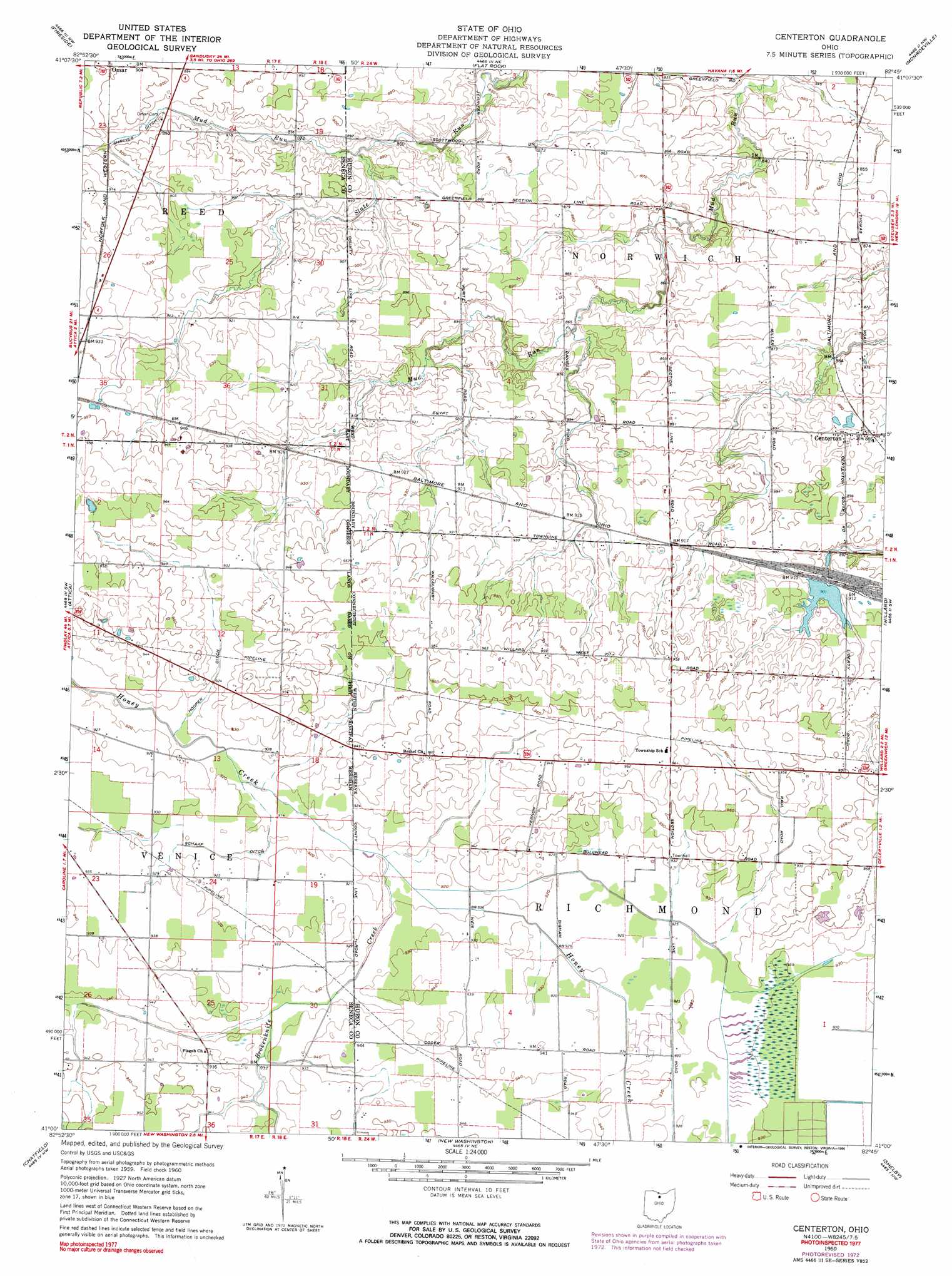
Centerton Topo Map Ohio
To zoom in, hover over the map of Centerton
USGS Topo Quad 41082a7 - 1:24,000 scale
| Topo Map Name: | Centerton |
| USGS Topo Quad ID: | 41082a7 |
| Print Size: | ca. 21 1/4" wide x 27" high |
| Southeast Coordinates: | 41° N latitude / 82.75° W longitude |
| Map Center Coordinates: | 41.0625° N latitude / 82.8125° W longitude |
| U.S. State: | OH |
| Filename: | o41082a7.jpg |
| Download Map JPG Image: | Centerton topo map 1:24,000 scale |
| Map Type: | Topographic |
| Topo Series: | 7.5´ |
| Map Scale: | 1:24,000 |
| Source of Map Images: | United States Geological Survey (USGS) |
| Alternate Map Versions: |
Centerton OH 1960, updated 1961 Download PDF Buy paper map Centerton OH 1960, updated 1973 Download PDF Buy paper map Centerton OH 1960, updated 1990 Download PDF Buy paper map Centerton OH 2010 Download PDF Buy paper map Centerton OH 2013 Download PDF Buy paper map Centerton OH 2016 Download PDF Buy paper map |
1:24,000 Topo Quads surrounding Centerton
Fremont East |
Clyde |
Bellevue |
Kimball |
Milan |
Watson |
Fireside |
Flat Rock |
Monroeville |
Norwalk |
Bloomville |
Attica |
Centerton |
Willard |
Greenwich |
Lykens |
Chatfield |
New Washington |
Shelby |
Shiloh |
Oceola |
Bucyrus |
North Robinson |
Crestline |
Mansfield North |
> Back to 41082a1 at 1:100,000 scale
> Back to 41082a1 at 1:250,000 scale
> Back to U.S. Topo Maps home
Centerton topo map: Gazetteer
Centerton: Canals
Hooper Ditch elevation 283m 928′Schaaf Ditch elevation 280m 918′
Centerton: Dams
B & O Railroad Pond 1026-001 Dam elevation 275m 902′Centerton: Parks
Willard Marsh Wildlife Area elevation 283m 928′Centerton: Populated Places
Centerton elevation 271m 889′Omar elevation 274m 898′
Relief (historical) elevation 281m 921′
Centerton: Post Offices
Centerton Post Office (historical) elevation 271m 889′Omar Post Office (historical) elevation 274m 898′
Centerton: Reservoirs
B & O Railroad Pond 1026-001 elevation 275m 902′Centerton: Streams
Brokenknife Creek elevation 280m 918′Mud Run elevation 262m 859′
Centerton: Swamps
New Haven Marsh elevation 283m 928′Centerton digital topo map on disk
Buy this Centerton topo map showing relief, roads, GPS coordinates and other geographical features, as a high-resolution digital map file on DVD:
 map DVD")