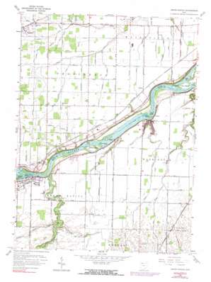
Grand Rapids Topo Map Ohio
To zoom in, hover over the map of Grand Rapids
USGS Topo Quad 41083d7 - 1:24,000 scale
| Topo Map Name: | Grand Rapids |
| USGS Topo Quad ID: | 41083d7 |
| Print Size: | ca. 21 1/4" wide x 27" high |
| Southeast Coordinates: | 41.375° N latitude / 83.75° W longitude |
| Map Center Coordinates: | 41.4375° N latitude / 83.8125° W longitude |
| U.S. State: | OH |
| Filename: | o41083d7.jpg |
| Download Map JPG Image: | Grand Rapids topo map 1:24,000 scale |
| Map Type: | Topographic |
| Topo Series: | 7.5´ |
| Map Scale: | 1:24,000 |
| Source of Map Images: | United States Geological Survey (USGS) |
| Alternate Map Versions: |
Grand Rapids OH 1935 Download PDF Buy paper map Grand Rapids OH 1952, updated 1953 Download PDF Buy paper map Grand Rapids OH 1958, updated 1960 Download PDF Buy paper map Grand Rapids OH 1958, updated 1973 Download PDF Buy paper map Grand Rapids OH 1958, updated 1990 Download PDF Buy paper map Grand Rapids OH 2010 Download PDF Buy paper map Grand Rapids OH 2013 Download PDF Buy paper map Grand Rapids OH 2016 Download PDF Buy paper map |
1:24,000 Topo Quads surrounding Grand Rapids
> Back to 41083a1 at 1:100,000 scale
> Back to 41082a1 at 1:250,000 scale
> Back to U.S. Topo Maps home
Grand Rapids topo map: Gazetteer
Grand Rapids: Airports
Herr Airport elevation 204m 669′Herr II Airport elevation 202m 662′
Grand Rapids: Areas
Tontogany Prairie elevation 203m 666′Grand Rapids: Canals
Aumend Ditch elevation 199m 652′Baumberger Ditch elevation 201m 659′
Blystone Ditch elevation 199m 652′
Disher Ditch elevation 199m 652′
Doran Ditch elevation 201m 659′
Estworthy Ditch elevation 199m 652′
Freeworth Ditch elevation 201m 659′
Harris Ditch elevation 199m 652′
Jeffers Ditch elevation 203m 666′
Krohn Ditch elevation 202m 662′
Laver Ditch elevation 203m 666′
Ludwig Ditch elevation 200m 656′
Miller Ditch elevation 203m 666′
Richman Ditch elevation 201m 659′
Ruhm Ditch elevation 201m 659′
Scherer Ditch elevation 201m 659′
Studer Ditch elevation 199m 652′
Suter Ditch elevation 199m 652′
Whitemeir Ditch elevation 199m 652′
Yawberg Ditch elevation 201m 659′
Grand Rapids: Dams
Lock Number 44 elevation 195m 639′Williams Burg Lake - East Dam elevation 196m 643′
Williamsburg Lake - West Dam elevation 196m 643′
Grand Rapids: Islands
Butler Island elevation 188m 616′Buttonwood Island elevation 193m 633′
Caseys Island elevation 192m 629′
Fox Island elevation 190m 623′
Hedges Island elevation 190m 623′
Howard Island elevation 195m 639′
Indian Island elevation 187m 613′
Millers Island elevation 190m 623′
Number 3 Island elevation 190m 623′
Otter Island elevation 190m 623′
Sheets Island elevation 191m 626′
Woodcock Island elevation 187m 613′
Grand Rapids: Parks
Grand Rapids Township Park elevation 202m 662′Providence Historic District elevation 201m 659′
Providence Metropark elevation 192m 629′
Grand Rapids: Populated Places
Bailey elevation 203m 666′Grand Rapids elevation 201m 659′
Neapolis elevation 204m 669′
Neowash (historical) elevation 201m 659′
Otsego elevation 191m 626′
Providence elevation 201m 659′
Riverview Trailer Court elevation 200m 656′
Tondagamies Village (historical) elevation 201m 659′
Williamsburg-On-The-River elevation 201m 659′
Grand Rapids: Post Offices
Bailey Post Office (historical) elevation 203m 666′Grand Rapids Post Office elevation 202m 662′
Neapolis Post Office elevation 204m 669′
Neowash Post Office (historical) elevation 201m 659′
Providence Post Office (historical) elevation 202m 662′
Grand Rapids: Rapids
Bear Rapids elevation 188m 616′Grand Rapids: Reservoirs
Williamsburg Lake elevation 196m 643′Grand Rapids: Streams
Beaver Creek elevation 192m 629′Kettle Run elevation 191m 626′
Little Beaver Creek elevation 196m 643′
Mosquito Creek elevation 195m 639′
Sister Creek elevation 189m 620′
Sugar Creek elevation 188m 616′
West Branch Tontogany Creek elevation 194m 636′
Grand Rapids: Trails
Anthony Wayne Trail elevation 201m 659′Grand Rapids digital topo map on disk
Buy this Grand Rapids topo map showing relief, roads, GPS coordinates and other geographical features, as a high-resolution digital map file on DVD:


