Whitehouse Topo Map Ohio
To zoom in, hover over the map of Whitehouse
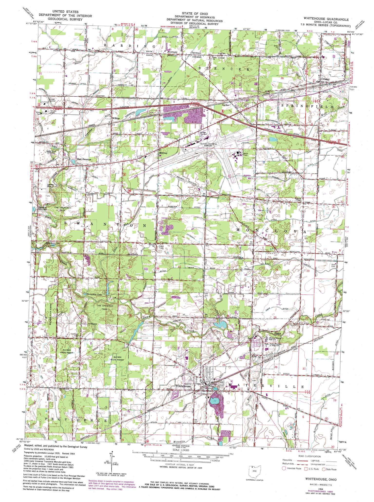
USGS Topo Quad 41083e7 - 1:24,000 scale
| Topo Map Name: | Whitehouse |
| USGS Topo Quad ID: | 41083e7 |
| Print Size: | ca. 21 1/4" wide x 27" high |
| Southeast Coordinates: | 41.5° N latitude / 83.75° W longitude |
| Map Center Coordinates: | 41.5625° N latitude / 83.8125° W longitude |
| U.S. State: | OH |
| Filename: | o41083e7.jpg |
| Download Map JPG Image: | Whitehouse topo map 1:24,000 scale |
| Map Type: | Topographic |
| Topo Series: | 7.5´ |
| Map Scale: | 1:24,000 |
| Source of Map Images: | United States Geological Survey (USGS) |
| Alternate Map Versions: |
Whitehouse OH 1935 Download PDF Buy paper map Whitehouse OH 1951, updated 1952 Download PDF Buy paper map Whitehouse OH 1964, updated 1966 Download PDF Buy paper map Whitehouse OH 1964, updated 1980 Download PDF Buy paper map Whitehouse OH 2010 Download PDF Buy paper map Whitehouse OH 2013 Download PDF Buy paper map Whitehouse OH 2016 Download PDF Buy paper map |
1:24,000 Topo Quads surrounding Whitehouse
Jasper |
Palmyra |
Blissfield |
Lambertville West |
Lambertville East |
Lyons |
Assumption |
Berkey |
Sylvania |
Toledo |
Delta |
Swanton |
Whitehouse |
Maumee |
Rossford |
Napoleon East |
Colton |
Grand Rapids |
Bowling Green North |
Dunbridge |
Malinta |
Mcclure |
Weston |
Bowling Green South |
Jerry City |
> Back to 41083e1 at 1:100,000 scale
> Back to 41082a1 at 1:250,000 scale
> Back to U.S. Topo Maps home
Whitehouse topo map: Gazetteer
Whitehouse: Airports
Rocky Ridge Airpark elevation 198m 649′Toledo Express Airport elevation 205m 672′
Zeigler Landing Strip elevation 207m 679′
Whitehouse: Canals
Bench Ditch elevation 206m 675′Benien Ditch elevation 203m 666′
Bovee Ditch elevation 203m 666′
Buchman Ditch elevation 195m 639′
Bushnell Ditch elevation 204m 669′
Butler Ditch elevation 200m 656′
Cairl Ditch elevation 195m 639′
Cunningham Ditch elevation 198m 649′
Cutshall Ditch elevation 203m 666′
Dennis Ditch elevation 206m 675′
Eber Ditch elevation 195m 639′
Evans Ditch elevation 203m 666′
Heath Ditch elevation 196m 643′
Hill Ditch elevation 206m 675′
Iron Ore Ditch elevation 203m 666′
Kujowski Central Ditch elevation 201m 659′
Lytle Ditch elevation 196m 643′
Muntwiller Ditch elevation 201m 659′
Murbach Ditch elevation 203m 666′
Oak Ditch elevation 197m 646′
Rakestraw Ditch elevation 199m 652′
Rhuland Ditch elevation 203m 666′
Ryan Ditch elevation 198m 649′
Scott Ditch elevation 203m 666′
Stone Ditch elevation 195m 639′
Strong Ditch elevation 208m 682′
Stull Ditch elevation 204m 669′
Van Fleet Ditch elevation 196m 643′
Webster Ditch elevation 204m 669′
Weot Ditch elevation 199m 652′
Wood Ditch elevation 196m 643′
Zaleski Ditch elevation 200m 656′
Whitehouse: Dams
Evergreen Lake Dam elevation 201m 659′Swanton Upground Reservoir Dam elevation 199m 652′
Whitehouse: Parks
Metropolitan Park elevation 196m 643′Oak Openings Preserve Metropark elevation 206m 675′
Whitehouse: Populated Places
Crissey elevation 198m 649′East Swanton elevation 204m 669′
Garden elevation 204m 669′
Midway elevation 208m 682′
Midway (historical) elevation 204m 669′
South Swanton elevation 204m 669′
Whitehouse elevation 199m 652′
Wilkins elevation 205m 672′
Whitehouse: Reservoirs
Evergreen Lake elevation 201m 659′Swanton Reservoir elevation 204m 669′
Swanton Upground Reservoir elevation 199m 652′
Whitehouse: Streams
Ai Creek elevation 199m 652′Blue Creek elevation 197m 646′
Gale Run elevation 195m 639′
Whitehouse digital topo map on disk
Buy this Whitehouse topo map showing relief, roads, GPS coordinates and other geographical features, as a high-resolution digital map file on DVD:
 map DVD")