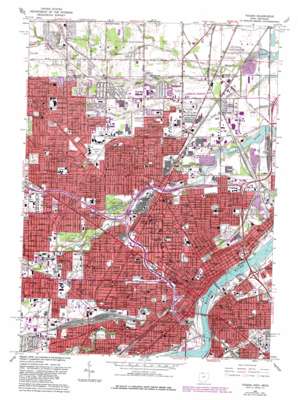
Toledo Topo Map Ohio
To zoom in, hover over the map of Toledo
USGS Topo Quad 41083f5 - 1:24,000 scale
| Topo Map Name: | Toledo |
| USGS Topo Quad ID: | 41083f5 |
| Print Size: | ca. 21 1/4" wide x 27" high |
| Southeast Coordinates: | 41.625° N latitude / 83.5° W longitude |
| Map Center Coordinates: | 41.6875° N latitude / 83.5625° W longitude |
| U.S. States: | OH, MI |
| Filename: | o41083f5.jpg |
| Download Map JPG Image: | Toledo topo map 1:24,000 scale |
| Map Type: | Topographic |
| Topo Series: | 7.5´ |
| Map Scale: | 1:24,000 |
| Source of Map Images: | United States Geological Survey (USGS) |
| Alternate Map Versions: |
Toledo OH 1952, updated 1954 Download PDF Buy paper map Toledo OH 1952, updated 1954 Download PDF Buy paper map Toledo OH 1965, updated 1968 Download PDF Buy paper map Toledo OH 1965, updated 1977 Download PDF Buy paper map Toledo OH 1965, updated 1980 Download PDF Buy paper map Toledo OH 1965, updated 1980 Download PDF Buy paper map Toledo OH 2011 Download PDF Buy paper map Toledo OH 2013 Download PDF Buy paper map Toledo OH 2016 Download PDF Buy paper map |
1:24,000 Topo Quads surrounding Toledo
> Back to 41083e1 at 1:100,000 scale
> Back to 41082a1 at 1:250,000 scale
> Back to U.S. Topo Maps home
Toledo topo map: Gazetteer
Toledo: Airports
Mercy Hospital Helistop elevation 187m 613′Riverside Hospital Heliport elevation 185m 606′
Saint Vincent Hospital and Medical Center Heliport elevation 186m 610′
Scott Park Heliport elevation 189m 620′
Seagate Helistop elevation 183m 600′
Toledo Hospital Heliport elevation 188m 616′
Toledo: Bridges
Anthony Wayne Bridge elevation 174m 570′Craig Memorial Bridge elevation 174m 570′
Martin Luther King Junior Memorial Bridge elevation 174m 570′
Michael Disalle Bridge elevation 174m 570′
Toledo: Canals
Bragden Ditch elevation 185m 606′Ketcham Ditch elevation 186m 610′
Peterson Ditch elevation 186m 610′
Tifft Ditch elevation 186m 610′
Williams Ditch elevation 187m 613′
Toledo: Crossings
Interchange 10A elevation 178m 583′Interchange 10B elevation 183m 600′
Interchange 10C elevation 175m 574′
Interchange 11 elevation 181m 593′
Interchange 12A elevation 178m 583′
Interchange 12B elevation 181m 593′
Interchange 19 elevation 183m 600′
Interchange 200 elevation 185m 606′
Interchange 201A elevation 180m 590′
Interchange 201B elevation 183m 600′
Interchange 202A elevation 183m 600′
Interchange 202B elevation 187m 613′
Interchange 203A elevation 187m 613′
Interchange 203B elevation 187m 613′
Interchange 205A elevation 175m 574′
Interchange 205B elevation 175m 574′
Interchange 206 elevation 179m 587′
Interchange 207 elevation 180m 590′
Interchange 208 elevation 180m 590′
Interchange 209 elevation 180m 590′
Interchange 20A elevation 180m 590′
Interchange 20B elevation 176m 577′
Interchange 210 elevation 178m 583′
Interchange 9 elevation 181m 593′
Toledo: Harbors
Riverside Turning Basin elevation 182m 597′Toledo: Parks
Asbury Park elevation 182m 597′Ashley Field elevation 186m 610′
Bass Playground elevation 188m 616′
Beatty Park elevation 175m 574′
Beatty Park elevation 175m 574′
Bennett Park elevation 182m 597′
Bowman Park elevation 184m 603′
Bush Street Historic District elevation 184m 603′
Centennial Mall elevation 182m 597′
Chippewa Playground elevation 192m 629′
Civic Center Mall elevation 181m 593′
Close Park elevation 187m 613′
Connelly Field elevation 189m 620′
Cumberland Street Historic District elevation 184m 603′
Dibble Park elevation 185m 606′
Glass Bowl Stadium elevation 180m 590′
Greenwood Park elevation 186m 610′
Gunckel Park elevation 187m 613′
Hamilton Playground elevation 188m 616′
Highland Park elevation 178m 583′
Hyde Park elevation 184m 603′
Jermain Park elevation 174m 570′
Joe E Brown Park elevation 182m 597′
Landers Park elevation 185m 606′
Levis Square elevation 180m 590′
Library Square elevation 181m 593′
Marvin Playground elevation 187m 613′
Miracle Park elevation 174m 570′
Mulberry Park elevation 180m 590′
Navarre Park elevation 180m 590′
North Collingwood Park elevation 182m 597′
Northgate Park elevation 181m 593′
Old West End Historic District elevation 186m 610′
Ottawa Park elevation 185m 606′
Pine Glen Park elevation 191m 626′
Prentice Park elevation 186m 610′
Promenade Park elevation 176m 577′
Riverside Park elevation 181m 593′
Saint Clair Street Historic District elevation 178m 583′
Saint Peter and Saint Paul Historic District elevation 187m 613′
Scott Park elevation 189m 620′
Scott Park elevation 186m 610′
Smith Park elevation 188m 616′
Sterling Field elevation 179m 587′
Thomas Edison Park elevation 177m 580′
Toledo Olde Towne Historic District elevation 186m 610′
Vistula Historic District elevation 184m 603′
Weller Playground elevation 186m 610′
Wernerts Field elevation 189m 620′
Westmoreland Historic District elevation 182m 597′
Willys Park elevation 178m 583′
Woodrow Wilson Park elevation 182m 597′
Toledo: Populated Places
Air Line Junction elevation 188m 616′Alexis Addition elevation 179m 587′
Auburndale elevation 187m 613′
Boulevard elevation 180m 590′
East Toledo elevation 185m 606′
Erie Mobile Home Village elevation 179m 587′
Ferndale elevation 190m 623′
Fitch elevation 187m 613′
Freemans Gardens elevation 189m 620′
Hallett elevation 180m 590′
Hopewell Heights elevation 186m 610′
Inverness Mobile Home Community elevation 183m 600′
Liberty Corners elevation 190m 623′
Mayfair Park elevation 184m 603′
Mellwood elevation 187m 613′
Nasby elevation 190m 623′
Northgate elevation 181m 593′
Northtown Meadows Mobile Home Park elevation 181m 593′
Oakwood Mobile Home Community elevation 181m 593′
Toledo elevation 187m 613′
Trilby elevation 193m 633′
Vulcan elevation 189m 620′
Wernerts Corners elevation 189m 620′
West Toledo elevation 184m 603′
Toledo: Post Offices
Airline Junction Post Office (historical) elevation 189m 620′Auburndale Post Office (historical) elevation 186m 610′
East Toledo Post Office (historical) elevation 185m 606′
Toledo Post Office elevation 186m 610′
Trilby Post Office (historical) elevation 193m 633′
West Toledo Post Office (historical) elevation 184m 603′
Toledo: Reservoirs
Scott Park Pond elevation 187m 613′Toledo: Streams
Indian Creek elevation 175m 574′Shantee Creek elevation 175m 574′
Sibley Creek elevation 174m 570′
Spring Brook elevation 184m 603′
Swan Creek elevation 175m 574′
Toledo: Summits
Sand Hill elevation 189m 620′Toledo digital topo map on disk
Buy this Toledo topo map showing relief, roads, GPS coordinates and other geographical features, as a high-resolution digital map file on DVD:


