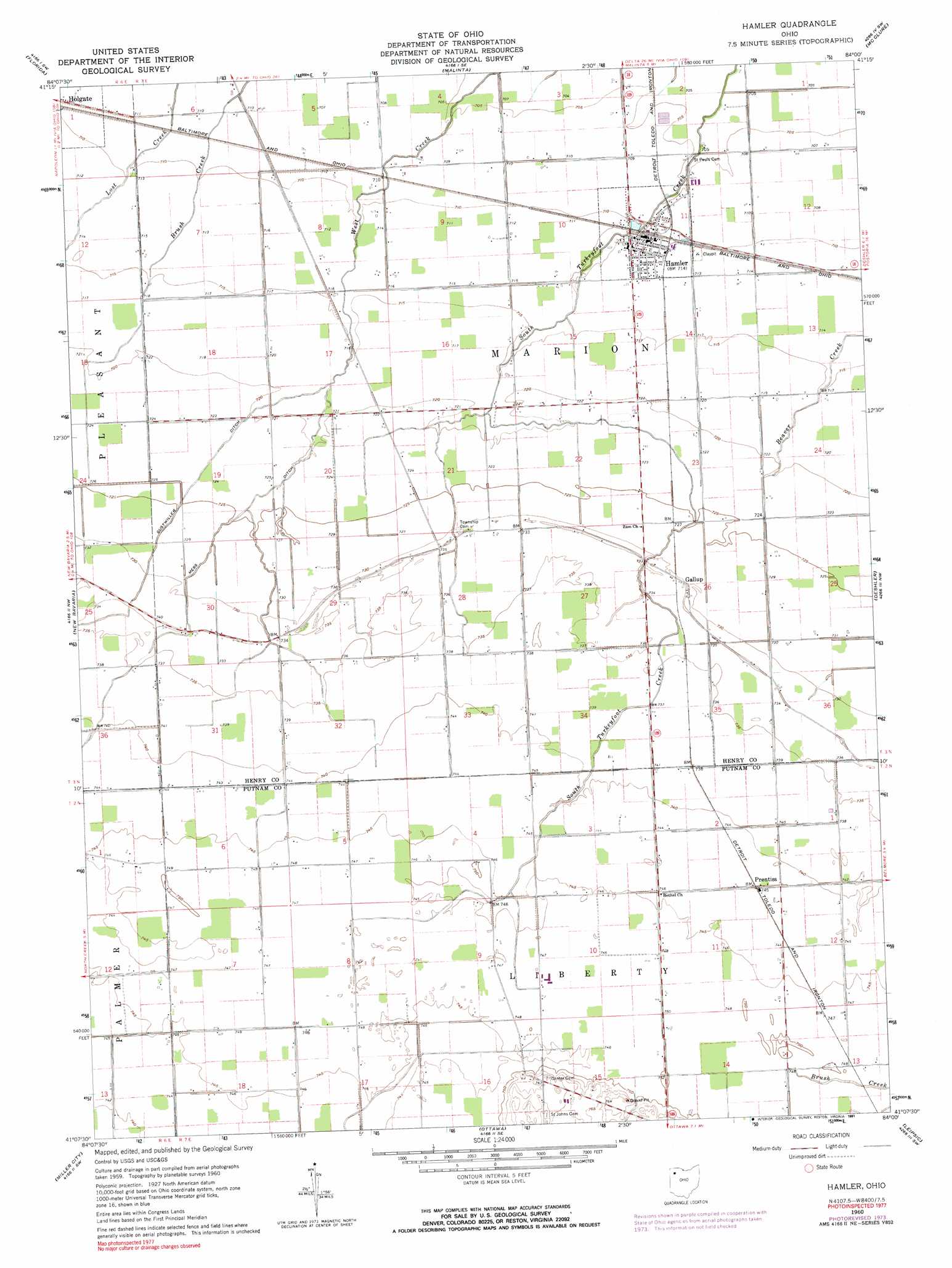
Hamler Topo Map Ohio
To zoom in, hover over the map of Hamler
USGS Topo Quad 41084b1 - 1:24,000 scale
| Topo Map Name: | Hamler |
| USGS Topo Quad ID: | 41084b1 |
| Print Size: | ca. 21 1/4" wide x 27" high |
| Southeast Coordinates: | 41.125° N latitude / 84° W longitude |
| Map Center Coordinates: | 41.1875° N latitude / 84.0625° W longitude |
| U.S. State: | OH |
| Filename: | o41084b1.jpg |
| Download Map JPG Image: | Hamler topo map 1:24,000 scale |
| Map Type: | Topographic |
| Topo Series: | 7.5´ |
| Map Scale: | 1:24,000 |
| Source of Map Images: | United States Geological Survey (USGS) |
| Alternate Map Versions: |
Hamler OH 1960, updated 1961 Download PDF Buy paper map Hamler OH 1960, updated 1991 Download PDF Buy paper map Hamler OH 2010 Download PDF Buy paper map Hamler OH 2013 Download PDF Buy paper map Hamler OH 2016 Download PDF Buy paper map |
1:24,000 Topo Quads surrounding Hamler
Ridgeville Corners |
Napoleon West |
Napoleon East |
Colton |
Grand Rapids |
Defiance East |
Florida |
Malinta |
Mcclure |
Weston |
Ayersville |
New Bavaria |
Hamler |
Deshler |
Hoytville |
Continental |
Miller City |
Ottawa |
Leipsic |
Mccomb |
Ottoville |
Kalida |
Columbus Grove |
Bluffton |
Rawson |
> Back to 41084a1 at 1:100,000 scale
> Back to 41084a1 at 1:250,000 scale
> Back to U.S. Topo Maps home
Hamler topo map: Gazetteer
Hamler: Canals
Gustwiller Ditch elevation 219m 718′Mess Ditch elevation 219m 718′
Hamler: Populated Places
Gallup elevation 224m 734′Hamler elevation 216m 708′
Madeira (historical) elevation 227m 744′
Prentiss elevation 225m 738′
Hamler: Post Offices
Gallup Post Office (historical) elevation 222m 728′Hamler Post Office elevation 216m 708′
Prentiss Post Office (historical) elevation 225m 738′
Hamler: Swamps
Beaver Swamp (historical) elevation 227m 744′Hamler digital topo map on disk
Buy this Hamler topo map showing relief, roads, GPS coordinates and other geographical features, as a high-resolution digital map file on DVD:
Northern Illinois, Northern Indiana & Southwestern Michigan
Buy digital topo maps: Northern Illinois, Northern Indiana & Southwestern Michigan