Bryan Topo Map Ohio
To zoom in, hover over the map of Bryan
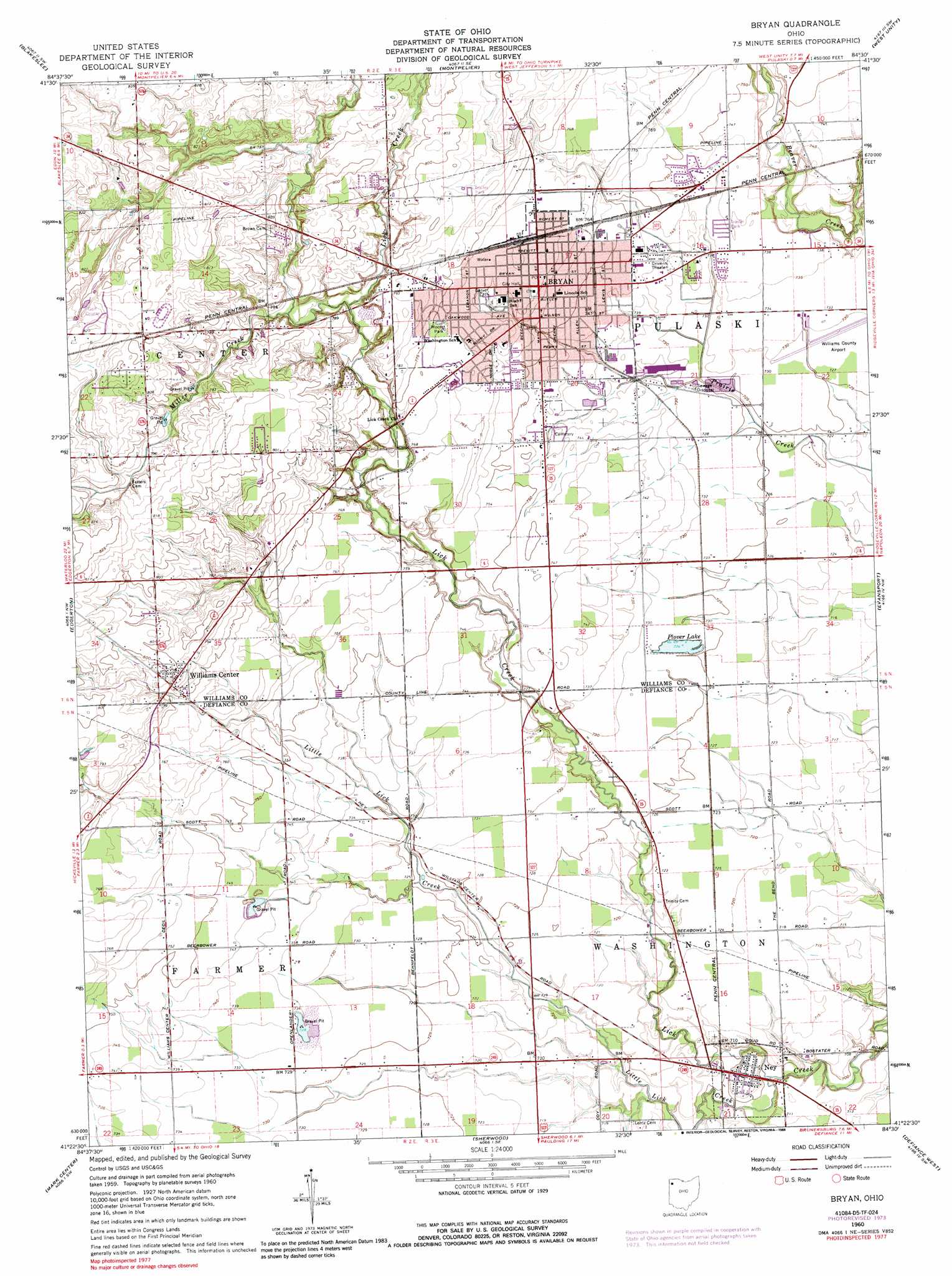
USGS Topo Quad 41084d5 - 1:24,000 scale
| Topo Map Name: | Bryan |
| USGS Topo Quad ID: | 41084d5 |
| Print Size: | ca. 21 1/4" wide x 27" high |
| Southeast Coordinates: | 41.375° N latitude / 84.5° W longitude |
| Map Center Coordinates: | 41.4375° N latitude / 84.5625° W longitude |
| U.S. State: | OH |
| Filename: | o41084d5.jpg |
| Download Map JPG Image: | Bryan topo map 1:24,000 scale |
| Map Type: | Topographic |
| Topo Series: | 7.5´ |
| Map Scale: | 1:24,000 |
| Source of Map Images: | United States Geological Survey (USGS) |
| Alternate Map Versions: |
Bryan OH 1960, updated 1961 Download PDF Buy paper map Bryan OH 1960, updated 1965 Download PDF Buy paper map Bryan OH 1960, updated 1973 Download PDF Buy paper map Bryan OH 1960, updated 1988 Download PDF Buy paper map Bryan OH 2010 Download PDF Buy paper map Bryan OH 2013 Download PDF Buy paper map Bryan OH 2016 Download PDF Buy paper map |
1:24,000 Topo Quads surrounding Bryan
Clear Lake |
Nettle Lake |
Pioneer |
Alvordton |
Fayette |
Edon |
Blakeslee |
Montpelier |
West Unity |
Archbold |
Butler East |
Edgerton |
Bryan |
Evansport |
Ridgeville Corners |
Hicksville |
Mark Center |
Sherwood |
Defiance West |
Defiance East |
Woodburn North |
Antwerp |
Paulding |
Junction |
Ayersville |
> Back to 41084a1 at 1:100,000 scale
> Back to 41084a1 at 1:250,000 scale
> Back to U.S. Topo Maps home
Bryan topo map: Gazetteer
Bryan: Airports
Williams County Airport elevation 222m 728′Bryan: Parks
Bryan Downtown Historic District elevation 233m 764′Fountain City Historic District elevation 234m 767′
Garver Park elevation 233m 764′
Moore Park elevation 236m 774′
Bryan: Populated Places
Bona Vesta elevation 227m 744′Bryan elevation 234m 767′
Durham Estates elevation 249m 816′
Freedom (historical) elevation 223m 731′
Holly Addition elevation 222m 728′
Jerrys First Addition elevation 247m 810′
Krohns Acres elevation 251m 823′
McDonald Subdivision elevation 233m 764′
Ney elevation 216m 708′
Norlick Place elevation 241m 790′
Oak Meadows elevation 244m 800′
Plover Lake Addition elevation 222m 728′
Rachel Heights elevation 233m 764′
Sinns Subdivision elevation 222m 728′
Williams Center elevation 241m 790′
Willow Glenn elevation 242m 793′
Bryan: Post Offices
Bryan Post Office elevation 233m 764′Ney Post Office elevation 216m 708′
Bryan: Reservoirs
Plower Lake elevation 221m 725′Bryan: Streams
Little Lick Creek elevation 212m 695′Miller Creek elevation 230m 754′
Bryan digital topo map on disk
Buy this Bryan topo map showing relief, roads, GPS coordinates and other geographical features, as a high-resolution digital map file on DVD:
Northern Illinois, Northern Indiana & Southwestern Michigan
Buy digital topo maps: Northern Illinois, Northern Indiana & Southwestern Michigan