Edon Topo Map Indiana
To zoom in, hover over the map of Edon
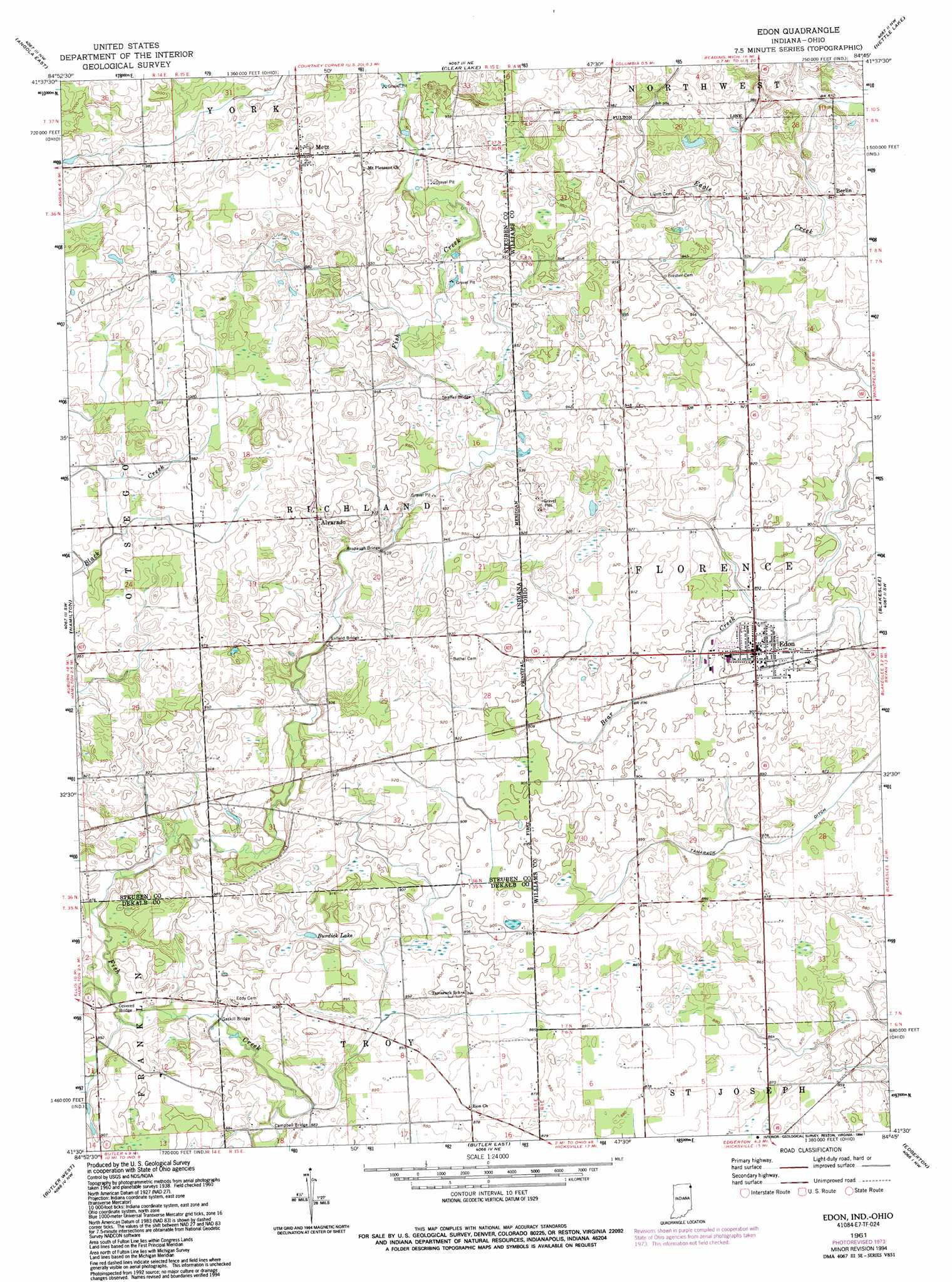
USGS Topo Quad 41084e7 - 1:24,000 scale
| Topo Map Name: | Edon |
| USGS Topo Quad ID: | 41084e7 |
| Print Size: | ca. 21 1/4" wide x 27" high |
| Southeast Coordinates: | 41.5° N latitude / 84.75° W longitude |
| Map Center Coordinates: | 41.5625° N latitude / 84.8125° W longitude |
| U.S. States: | IN, OH |
| Filename: | o41084e7.jpg |
| Download Map JPG Image: | Edon topo map 1:24,000 scale |
| Map Type: | Topographic |
| Topo Series: | 7.5´ |
| Map Scale: | 1:24,000 |
| Source of Map Images: | United States Geological Survey (USGS) |
| Alternate Map Versions: |
Metz OH 1940 Download PDF Buy paper map Metz OH 1940 Download PDF Buy paper map Edon OH 1961, updated 1963 Download PDF Buy paper map Edon OH 1961, updated 1974 Download PDF Buy paper map Edon OH 1961, updated 1990 Download PDF Buy paper map Edon OH 1961, updated 1994 Download PDF Buy paper map Edon OH 2010 Download PDF Buy paper map Edon OH 2013 Download PDF Buy paper map Edon OH 2016 Download PDF Buy paper map |
1:24,000 Topo Quads surrounding Edon
Kinderhook |
California |
Camden |
Reading |
Frontier |
Angola West |
Angola East |
Clear Lake |
Nettle Lake |
Pioneer |
Ashley |
Hamilton |
Edon |
Blakeslee |
Montpelier |
Waterloo |
Butler West |
Butler East |
Edgerton |
Bryan |
Auburn |
Saint Joe |
Hicksville |
Mark Center |
Sherwood |
> Back to 41084e1 at 1:100,000 scale
> Back to 41084a1 at 1:250,000 scale
> Back to U.S. Topo Maps home
Edon topo map: Gazetteer
Edon: Bridges
Anspaugh Bridge elevation 289m 948′Campbell Bridge elevation 262m 859′
Enfield Bridge elevation 284m 931′
Gaskill Bridge elevation 265m 869′
Shaffer Bridge elevation 284m 931′
Shaffer Bridge elevation 284m 931′
Edon: Canals
Tamarack Ditch elevation 265m 869′Edon: Lakes
Burdick Lake elevation 277m 908′Edon: Parks
Edon Community Park elevation 269m 882′Edon: Populated Places
Alvarado elevation 292m 958′Berlin elevation 287m 941′
Edon elevation 274m 898′
Metz elevation 301m 987′
Edon: Streams
Hiram Sweet Ditch elevation 265m 869′Matthews Creek elevation 268m 879′
Edon digital topo map on disk
Buy this Edon topo map showing relief, roads, GPS coordinates and other geographical features, as a high-resolution digital map file on DVD:
Northern Illinois, Northern Indiana & Southwestern Michigan
Buy digital topo maps: Northern Illinois, Northern Indiana & Southwestern Michigan