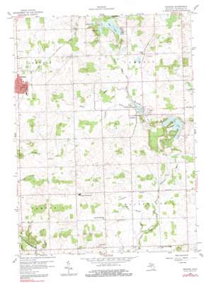
Reading Topo Map Michigan
To zoom in, hover over the map of Reading
USGS Topo Quad 41084g6 - 1:24,000 scale
| Topo Map Name: | Reading |
| USGS Topo Quad ID: | 41084g6 |
| Print Size: | ca. 21 1/4" wide x 27" high |
| Southeast Coordinates: | 41.75° N latitude / 84.625° W longitude |
| Map Center Coordinates: | 41.8125° N latitude / 84.6875° W longitude |
| U.S. State: | MI |
| Filename: | o41084g6.jpg |
| Download Map JPG Image: | Reading topo map 1:24,000 scale |
| Map Type: | Topographic |
| Topo Series: | 7.5´ |
| Map Scale: | 1:24,000 |
| Source of Map Images: | United States Geological Survey (USGS) |
| Alternate Map Versions: |
Reading MI 1959, updated 1960 Download PDF Buy paper map Reading MI 1959, updated 1981 Download PDF Buy paper map Reading MI 2011 Download PDF Buy paper map Reading MI 2014 Download PDF Buy paper map Reading MI 2016 Download PDF Buy paper map |
1:24,000 Topo Quads surrounding Reading
> Back to 41084e1 at 1:100,000 scale
> Back to 41084a1 at 1:250,000 scale
> Back to U.S. Topo Maps home
Reading topo map: Gazetteer
Reading: Lakes
Bear Lake elevation 322m 1056′Broom Lake elevation 323m 1059′
Cub Lake elevation 314m 1030′
Pike Lake elevation 322m 1056′
Reading: Parks
Rotary Park elevation 361m 1184′Water Works Park elevation 364m 1194′
Reading: Populated Places
Cambria elevation 329m 1079′Reading elevation 363m 1190′
Southern Belle Mobile Community elevation 330m 1082′
Reading: Post Offices
Cambria Post Office (historical) elevation 329m 1079′Cambria Post Office (historical) elevation 308m 1010′
Reading Post Office elevation 363m 1190′
Reading: Reservoirs
Cambria Millpond elevation 318m 1043′Cambria Millpond elevation 319m 1046′
Reading: Streams
Cambria Drain elevation 319m 1046′Carruthers Drain elevation 308m 1010′
Jonas Brown Drain elevation 304m 997′
Meade Drain elevation 320m 1049′
Reading digital topo map on disk
Buy this Reading topo map showing relief, roads, GPS coordinates and other geographical features, as a high-resolution digital map file on DVD:
Northern Illinois, Northern Indiana & Southwestern Michigan
Buy digital topo maps: Northern Illinois, Northern Indiana & Southwestern Michigan


