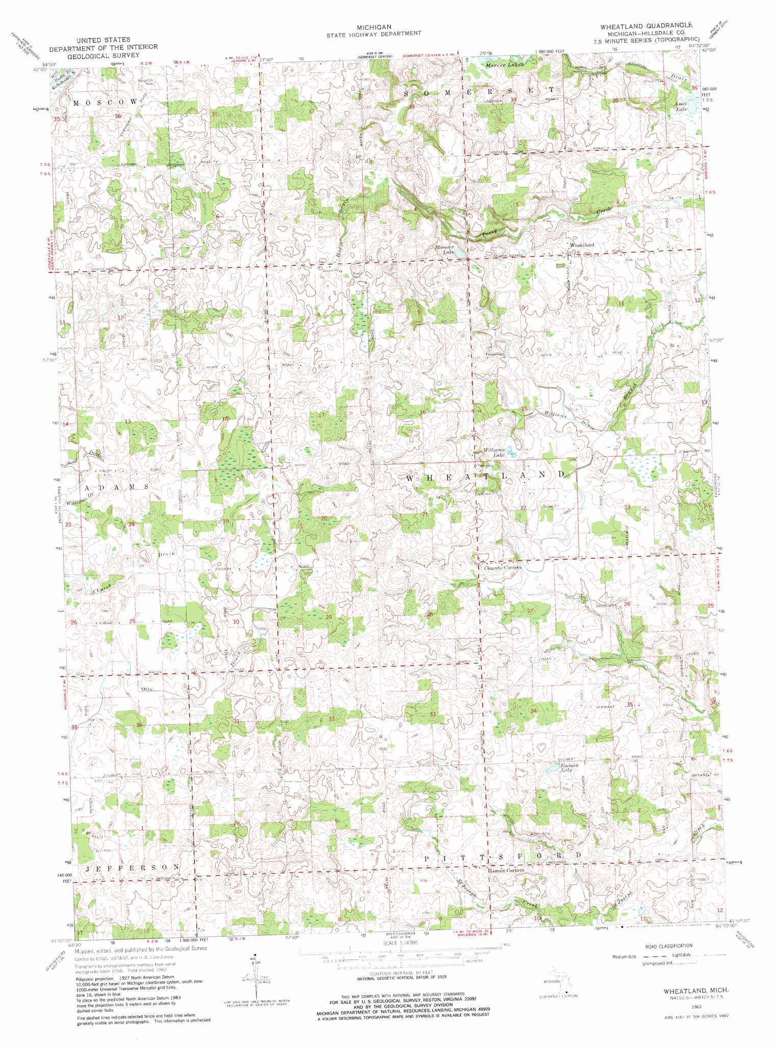
Wheatland Topo Map Michigan
To zoom in, hover over the map of Wheatland
USGS Topo Quad 41084h4 - 1:24,000 scale
| Topo Map Name: | Wheatland |
| USGS Topo Quad ID: | 41084h4 |
| Print Size: | ca. 21 1/4" wide x 27" high |
| Southeast Coordinates: | 41.875° N latitude / 84.375° W longitude |
| Map Center Coordinates: | 41.9375° N latitude / 84.4375° W longitude |
| U.S. State: | MI |
| Filename: | o41084h4.jpg |
| Download Map JPG Image: | Wheatland topo map 1:24,000 scale |
| Map Type: | Topographic |
| Topo Series: | 7.5´ |
| Map Scale: | 1:24,000 |
| Source of Map Images: | United States Geological Survey (USGS) |
| Alternate Map Versions: |
Wheatland MI 1962, updated 1963 Download PDF Buy paper map Wheatland MI 1962, updated 1982 Download PDF Buy paper map Wheatland MI 2011 Download PDF Buy paper map Wheatland MI 2014 Download PDF Buy paper map Wheatland MI 2016 Download PDF Buy paper map |
1:24,000 Topo Quads surrounding Wheatland
Southeast Albion |
Spring Arbor |
Jackson South |
Michigan Center |
Norvell |
Mosherville |
Hanover |
Somerset Center |
Cement City |
Onsted |
Hillsdale |
North Adams |
Wheatland |
Addison |
Rome Center |
Reading |
Frontier |
Pittsford |
Hudson |
Clayton |
Nettle Lake |
Pioneer |
Alvordton |
Fayette |
Morenci |
> Back to 41084e1 at 1:100,000 scale
> Back to 41084a1 at 1:250,000 scale
> Back to U.S. Topo Maps home
Wheatland topo map: Gazetteer
Wheatland: Lakes
Ames Lake elevation 308m 1010′Bloomer Lake elevation 334m 1095′
Embach Lake elevation 326m 1069′
Mercer Lakes elevation 320m 1049′
Williams Lake elevation 321m 1053′
Wheatland: Populated Places
Locust Corners elevation 328m 1076′Wheatland elevation 336m 1102′
Wheatland: Post Offices
Church Post Office (historical) elevation 352m 1154′Hoxie Post Office (historical) elevation 369m 1210′
Locust Post Office (historical) elevation 328m 1076′
Stafford Post Office (historical) elevation 320m 1049′
Wheatland Post Office (historical) elevation 336m 1102′
Wheatland: Streams
Hoxie Drain elevation 339m 1112′Williams Drain elevation 318m 1043′
Wheatland digital topo map on disk
Buy this Wheatland topo map showing relief, roads, GPS coordinates and other geographical features, as a high-resolution digital map file on DVD:
Northern Illinois, Northern Indiana & Southwestern Michigan
Buy digital topo maps: Northern Illinois, Northern Indiana & Southwestern Michigan