Fort Wayne East Topo Map Indiana
To zoom in, hover over the map of Fort Wayne East
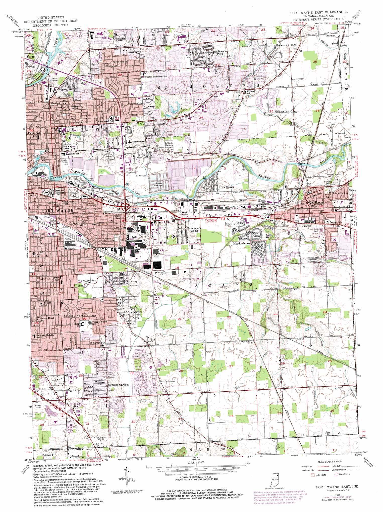
USGS Topo Quad 41085a1 - 1:24,000 scale
| Topo Map Name: | Fort Wayne East |
| USGS Topo Quad ID: | 41085a1 |
| Print Size: | ca. 21 1/4" wide x 27" high |
| Southeast Coordinates: | 41° N latitude / 85° W longitude |
| Map Center Coordinates: | 41.0625° N latitude / 85.0625° W longitude |
| U.S. State: | IN |
| Filename: | o41085a1.jpg |
| Download Map JPG Image: | Fort Wayne East topo map 1:24,000 scale |
| Map Type: | Topographic |
| Topo Series: | 7.5´ |
| Map Scale: | 1:24,000 |
| Source of Map Images: | United States Geological Survey (USGS) |
| Alternate Map Versions: |
Fort Wayne East IN 1956, updated 1958 Download PDF Buy paper map Fort Wayne East IN 1963, updated 1965 Download PDF Buy paper map Fort Wayne East IN 1963, updated 1974 Download PDF Buy paper map Fort Wayne East IN 1963, updated 1982 Download PDF Buy paper map Fort Wayne East IN 1998, updated 2001 Download PDF Buy paper map Fort Wayne East IN 2010 Download PDF Buy paper map Fort Wayne East IN 2013 Download PDF Buy paper map Fort Wayne East IN 2016 Download PDF Buy paper map |
1:24,000 Topo Quads surrounding Fort Wayne East
Ege |
Garrett |
Auburn |
Saint Joe |
Hicksville |
Churubusco |
Huntertown |
Cedarville |
Grabill |
Woodburn North |
Arcola |
Fort Wayne West |
Fort Wayne East |
Maples |
Woodburn South |
Zanesville |
Ossian |
Poe |
Hoagland |
Dixon |
Markle |
Uniondale |
Preble |
Decatur |
Wren |
> Back to 41085a1 at 1:100,000 scale
> Back to 41084a1 at 1:250,000 scale
> Back to U.S. Topo Maps home
Fort Wayne East topo map: Gazetteer
Fort Wayne East: Canals
Adams Ditch elevation 240m 787′Bender Ditch elevation 235m 770′
Bullerman Ditch elevation 238m 780′
Cochoit Ditch elevation 237m 777′
Doctor Ditch elevation 238m 780′
Grabner Ditch elevation 233m 764′
Koester Ditch elevation 232m 761′
Schmidt Ditch elevation 238m 780′
Schneider Ditch elevation 242m 793′
Fort Wayne East: Crossings
Interchange 15 elevation 244m 800′Interchange 17 elevation 243m 797′
Fort Wayne East: Dams
Saint Joseph River Dam elevation 236m 774′Fort Wayne East: Parks
Johnny Appleseed Memorial Park elevation 231m 757′Lions Park elevation 244m 800′
McMillen Park elevation 247m 810′
Memorial Stadium (historical) elevation 232m 761′
Zollner Stadium elevation 235m 770′
Fort Wayne East: Populated Places
Anthony Wayne Village elevation 246m 807′Dwenger Field elevation 231m 757′
Eastland Gardens elevation 245m 803′
Fairfax elevation 238m 780′
Greendale elevation 243m 797′
Hacienda Village elevation 236m 774′
Maplewood Park elevation 243m 797′
Meadowbrook elevation 233m 764′
New Haven elevation 231m 757′
River Haven elevation 229m 751′
Sunnymede Woods elevation 243m 797′
Tanglewood elevation 233m 764′
Thurman elevation 233m 764′
Fort Wayne East: Streams
Bullerman Branch elevation 235m 770′Fort Wayne East digital topo map on disk
Buy this Fort Wayne East topo map showing relief, roads, GPS coordinates and other geographical features, as a high-resolution digital map file on DVD:
Northern Illinois, Northern Indiana & Southwestern Michigan
Buy digital topo maps: Northern Illinois, Northern Indiana & Southwestern Michigan