Pierceton Topo Map Indiana
To zoom in, hover over the map of Pierceton
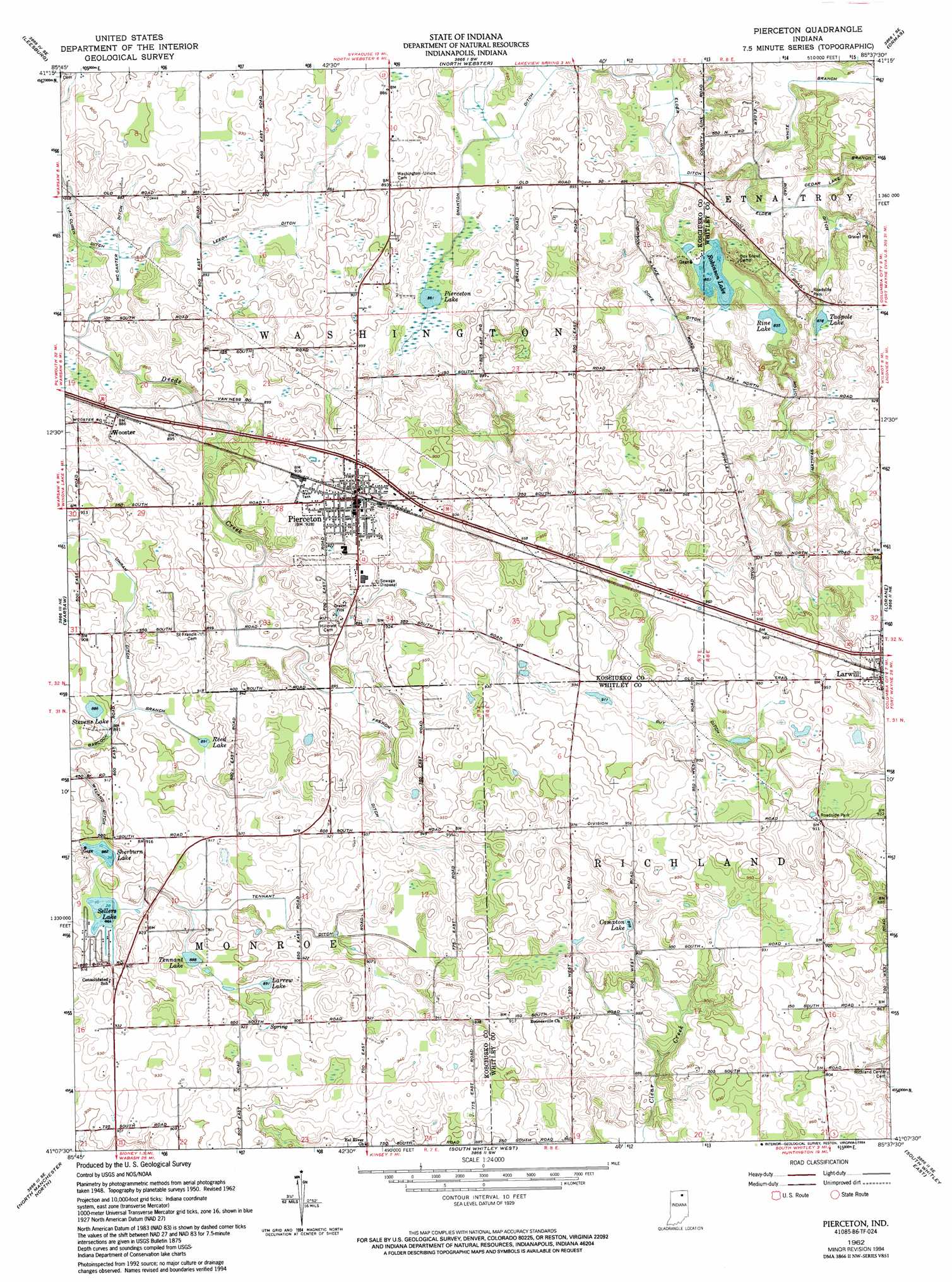
USGS Topo Quad 41085b6 - 1:24,000 scale
| Topo Map Name: | Pierceton |
| USGS Topo Quad ID: | 41085b6 |
| Print Size: | ca. 21 1/4" wide x 27" high |
| Southeast Coordinates: | 41.125° N latitude / 85.625° W longitude |
| Map Center Coordinates: | 41.1875° N latitude / 85.6875° W longitude |
| U.S. State: | IN |
| Filename: | o41085b6.jpg |
| Download Map JPG Image: | Pierceton topo map 1:24,000 scale |
| Map Type: | Topographic |
| Topo Series: | 7.5´ |
| Map Scale: | 1:24,000 |
| Source of Map Images: | United States Geological Survey (USGS) |
| Alternate Map Versions: |
Pierceton IN 1950, updated 1952 Download PDF Buy paper map Pierceton IN 1962, updated 1964 Download PDF Buy paper map Pierceton IN 1962, updated 1994 Download PDF Buy paper map Pierceton IN 2010 Download PDF Buy paper map Pierceton IN 2013 Download PDF Buy paper map Pierceton IN 2016 Download PDF Buy paper map |
1:24,000 Topo Quads surrounding Pierceton
Nappanee East |
Milford |
Lake Wawasee |
Ligonier |
Albion |
Atwood |
Leesburg |
North Webster |
Ormas |
Merriam |
Burket |
Warsaw |
Pierceton |
Lorane |
Columbia City |
Silver Lake |
North Manchester North |
South Whitley West |
South Whitley East |
Laud |
Roann |
North Manchester South |
Servia |
Bippus |
Huntington |
> Back to 41085a1 at 1:100,000 scale
> Back to 41084a1 at 1:250,000 scale
> Back to U.S. Topo Maps home
Pierceton topo map: Gazetteer
Pierceton: Canals
Doke Ditch elevation 267m 875′Elder Ditch elevation 262m 859′
French Ditch elevation 275m 902′
Guy Ditch elevation 288m 944′
Leedy Ditch elevation 265m 869′
Mathias Ditch elevation 271m 889′
McCarter Ditch elevation 258m 846′
Shanton Ditch elevation 261m 856′
Tennant Ditch elevation 275m 902′
Unrah Ditch elevation 275m 902′
White Branch elevation 262m 859′
Pierceton: Lakes
Compton Lake elevation 274m 898′Larrew Lake elevation 272m 892′
Pierceton Lake elevation 262m 859′
Reed Lake elevation 269m 882′
Rine Lake elevation 260m 853′
Robinson Lake elevation 260m 853′
Sellers Lake elevation 267m 875′
Sherburn Lake elevation 269m 882′
Stevens Lake elevation 270m 885′
Tadpole Lake elevation 267m 875′
Tennant Lake elevation 270m 885′
Pierceton: Populated Places
Larwill elevation 294m 964′Pierceton elevation 283m 928′
Wooster elevation 271m 889′
Pierceton: Streams
Cedar Lake Branch elevation 264m 866′Pierceton digital topo map on disk
Buy this Pierceton topo map showing relief, roads, GPS coordinates and other geographical features, as a high-resolution digital map file on DVD:
Northern Illinois, Northern Indiana & Southwestern Michigan
Buy digital topo maps: Northern Illinois, Northern Indiana & Southwestern Michigan