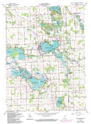
North Webster Topo Map Indiana
To zoom in, hover over the map of North Webster
USGS Topo Quad 41085c6 - 1:24,000 scale
| Topo Map Name: | North Webster |
| USGS Topo Quad ID: | 41085c6 |
| Print Size: | ca. 21 1/4" wide x 27" high |
| Southeast Coordinates: | 41.25° N latitude / 85.625° W longitude |
| Map Center Coordinates: | 41.3125° N latitude / 85.6875° W longitude |
| U.S. State: | IN |
| Filename: | o41085c6.jpg |
| Download Map JPG Image: | North Webster topo map 1:24,000 scale |
| Map Type: | Topographic |
| Topo Series: | 7.5´ |
| Map Scale: | 1:24,000 |
| Source of Map Images: | United States Geological Survey (USGS) |
| Alternate Map Versions: |
North Webster IN 1950, updated 1952 Download PDF Buy paper map North Webster IN 1962, updated 1964 Download PDF Buy paper map North Webster IN 1962, updated 1976 Download PDF Buy paper map North Webster IN 1962, updated 1982 Download PDF Buy paper map North Webster IN 1962, updated 1994 Download PDF Buy paper map North Webster IN 2010 Download PDF Buy paper map North Webster IN 2013 Download PDF Buy paper map North Webster IN 2016 Download PDF Buy paper map |
1:24,000 Topo Quads surrounding North Webster
> Back to 41085a1 at 1:100,000 scale
> Back to 41084a1 at 1:250,000 scale
> Back to U.S. Topo Maps home
North Webster topo map: Gazetteer
North Webster: Canals
Kuhn Ditch elevation 264m 866′Puntney Ditch elevation 266m 872′
North Webster: Dams
Rider Lake Dam elevation 267m 875′Webster Lake Dam-East elevation 261m 856′
Weimer Black Dam elevation 268m 879′
North Webster: Lakes
Allen Lake elevation 266m 872′Banning Lake elevation 255m 836′
Barel-and-a-Half Lake elevation 265m 869′
Big Barbee Lake elevation 254m 833′
Black Lake elevation 263m 862′
Duely Lake elevation 267m 875′
Durham Lake elevation 262m 859′
Gordy Lake elevation 267m 875′
Greider Lake elevation 261m 856′
Grindle Lake elevation 260m 853′
Hammond Lake elevation 266m 872′
Heron Lake elevation 257m 843′
Irish Lake elevation 254m 833′
James Lake elevation 255m 836′
Kiser Lake elevation 260m 853′
Kuhn Lake elevation 254m 833′
Little Barbee Lake elevation 255m 836′
Long Lake elevation 273m 895′
Morehead Lake elevation 272m 892′
Pisgah Lake elevation 263m 862′
Price Lake elevation 267m 875′
Rider Lake elevation 267m 875′
Ridinger Lake elevation 258m 846′
Rothenbeger Lake elevation 266m 872′
Sawmill Lake elevation 254m 833′
Sechrist Lake elevation 254m 833′
Shock Lake elevation 266m 872′
Shoe Lake elevation 256m 839′
Snoke Lake elevation 261m 856′
Spear Lake elevation 265m 869′
The Backwaters elevation 262m 859′
Village Lake elevation 267m 875′
Webster Lake elevation 261m 856′
Wyland Lake elevation 275m 902′
North Webster: Parks
Camp Crosley elevation 263m 862′Camp Dick Runyan elevation 256m 839′
Camp Tippecanoe elevation 265m 869′
Tri-County State Fish And Game Area elevation 265m 869′
North Webster: Populated Places
Barbee elevation 257m 843′Bayfield elevation 259m 849′
Between-The-Lakes Park elevation 257m 843′
Eagle Point elevation 260m 853′
Epworth Forest elevation 268m 879′
Highbanks elevation 271m 889′
Indian Village elevation 270m 885′
Lakeview Spring elevation 256m 839′
Mineral Springs elevation 258m 846′
North Webster elevation 269m 882′
Wilmot elevation 271m 889′
Yellowbanks elevation 262m 859′
North Webster: Reservoirs
Goldeneye Pond elevation 268m 879′Papakeechie Lake elevation 264m 866′
Wilmot Pond elevation 267m 875′
North Webster: Streams
Grassy Creek elevation 255m 836′North Webster: Summits
Dunham Hill elevation 285m 935′North Webster digital topo map on disk
Buy this North Webster topo map showing relief, roads, GPS coordinates and other geographical features, as a high-resolution digital map file on DVD:
Northern Illinois, Northern Indiana & Southwestern Michigan
Buy digital topo maps: Northern Illinois, Northern Indiana & Southwestern Michigan


