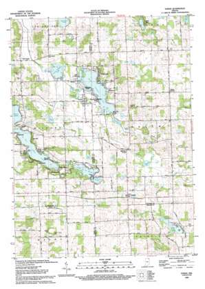
Stroh Topo Map Indiana
To zoom in, hover over the map of Stroh
USGS Topo Quad 41085e2 - 1:24,000 scale
| Topo Map Name: | Stroh |
| USGS Topo Quad ID: | 41085e2 |
| Print Size: | ca. 21 1/4" wide x 27" high |
| Southeast Coordinates: | 41.5° N latitude / 85.125° W longitude |
| Map Center Coordinates: | 41.5625° N latitude / 85.1875° W longitude |
| U.S. State: | IN |
| Filename: | o41085e2.jpg |
| Download Map JPG Image: | Stroh topo map 1:24,000 scale |
| Map Type: | Topographic |
| Topo Series: | 7.5´ |
| Map Scale: | 1:24,000 |
| Source of Map Images: | United States Geological Survey (USGS) |
| Alternate Map Versions: |
Stroh IN 1942 Download PDF Buy paper map Stroh IN 1959, updated 1960 Download PDF Buy paper map Stroh IN 1959, updated 1990 Download PDF Buy paper map Stroh IN 1993, updated 1993 Download PDF Buy paper map Stroh IN 2010 Download PDF Buy paper map Stroh IN 2013 Download PDF Buy paper map Stroh IN 2016 Download PDF Buy paper map |
1:24,000 Topo Quads surrounding Stroh
> Back to 41085e1 at 1:100,000 scale
> Back to 41084a1 at 1:250,000 scale
> Back to U.S. Topo Maps home
Stroh topo map: Gazetteer
Stroh: Canals
Hutchins Ditch elevation 305m 1000′Maumee Ditch elevation 296m 971′
Stump Ditch elevation 285m 935′
Uhl Ditch elevation 294m 964′
Stroh: Islands
Block Island elevation 287m 941′Stroh: Lakes
Appleman Lake elevation 295m 967′Big Long Lake elevation 290m 951′
Big Turkey Lake elevation 281m 921′
Duck Pond elevation 289m 948′
Goose Pond elevation 289m 948′
Hayward Lake elevation 282m 925′
Henry Lake elevation 283m 928′
Lake Arrowhead elevation 293m 961′
Lake of the Woods elevation 289m 948′
Limekiln Lake elevation 283m 928′
Little Turkey Lake elevation 282m 925′
Lower Story Lake elevation 287m 941′
McClish Lake elevation 290m 951′
Mud Lake elevation 282m 925′
Pretty Lake elevation 292m 958′
Spectacle Lakes elevation 290m 951′
Story Lake elevation 287m 941′
Taylor Lake elevation 287m 941′
The Basin elevation 297m 974′
Upper Story Lake elevation 287m 941′
Stroh: Parks
Camp Lakewood elevation 301m 987′Stroh: Populated Places
Elmira elevation 283m 928′Gravel Beach elevation 300m 984′
Greenwood elevation 304m 997′
Hartzel elevation 305m 1000′
Helmer elevation 297m 974′
Indian Hills elevation 309m 1013′
Indianola elevation 294m 964′
Lakeside Park elevation 282m 925′
Lakeview elevation 296m 971′
Meadow Shores Park elevation 284m 931′
Mount Pisgah elevation 296m 971′
Oak Lodge elevation 282m 925′
Ramblewood elevation 300m 984′
Salem Center elevation 320m 1049′
Shady Nook elevation 297m 974′
Sha-Get Acres elevation 283m 928′
Stroh elevation 285m 935′
Tall Timbers elevation 301m 987′
Timberhurst elevation 292m 958′
Turkey Creek elevation 287m 941′
Westview elevation 284m 931′
Wildwood elevation 285m 935′
Woodland Park elevation 293m 961′
Stroh: Streams
Mud Creek elevation 282m 925′Mud Creek elevation 295m 967′
Stroh: Summits
Sand Hill elevation 327m 1072′Stroh digital topo map on disk
Buy this Stroh topo map showing relief, roads, GPS coordinates and other geographical features, as a high-resolution digital map file on DVD:
Northern Illinois, Northern Indiana & Southwestern Michigan
Buy digital topo maps: Northern Illinois, Northern Indiana & Southwestern Michigan


