Sturgis Topo Map Michigan
To zoom in, hover over the map of Sturgis
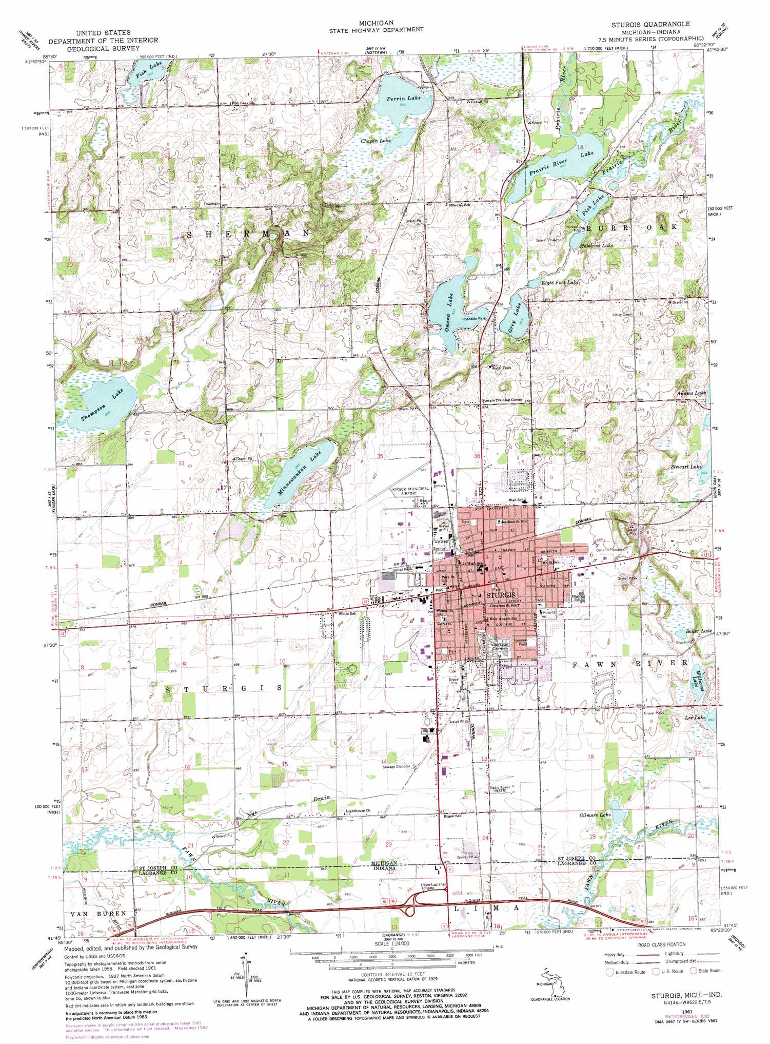
USGS Topo Quad 41085g4 - 1:24,000 scale
| Topo Map Name: | Sturgis |
| USGS Topo Quad ID: | 41085g4 |
| Print Size: | ca. 21 1/4" wide x 27" high |
| Southeast Coordinates: | 41.75° N latitude / 85.375° W longitude |
| Map Center Coordinates: | 41.8125° N latitude / 85.4375° W longitude |
| U.S. States: | MI, IN |
| Filename: | o41085g4.jpg |
| Download Map JPG Image: | Sturgis topo map 1:24,000 scale |
| Map Type: | Topographic |
| Topo Series: | 7.5´ |
| Map Scale: | 1:24,000 |
| Source of Map Images: | United States Geological Survey (USGS) |
| Alternate Map Versions: |
Sturgis MI 1961, updated 1962 Download PDF Buy paper map Sturgis MI 1961, updated 1982 Download PDF Buy paper map Sturgis MI 2011 Download PDF Buy paper map Sturgis MI 2014 Download PDF Buy paper map Sturgis MI 2016 Download PDF Buy paper map |
1:24,000 Topo Quads surrounding Sturgis
Schoolcraft |
Vicksburg |
Mendon |
Leonidas |
Union City |
Three Rivers West |
Three Rivers East |
Nottawa |
Colon |
Bronson North |
Constantine |
Klinger Lake |
Sturgis |
Burr Oak |
Bronson South |
Middlebury |
Shipshewana |
Lagrange |
Mongo |
Orland |
Millersburg |
Topeka |
Oliver Lake |
Wolcottville |
Stroh |
> Back to 41085e1 at 1:100,000 scale
> Back to 41084a1 at 1:250,000 scale
> Back to U.S. Topo Maps home
Sturgis topo map: Gazetteer
Sturgis: Airports
Kirsch Municipal Airport elevation 281m 921′Sturgis: Canals
Wenger Ditch elevation 256m 839′Sturgis: Lakes
Baker Lake elevation 264m 866′Chapin Lake elevation 260m 853′
Eight Foot Lake elevation 258m 846′
Fish Lake elevation 258m 846′
Gilmore Lake elevation 262m 859′
Grey Lake elevation 259m 849′
Hawkins Lake elevation 258m 846′
Minnewaukan Lake elevation 263m 862′
Omena Lake elevation 260m 853′
Perrin Lake elevation 260m 853′
Prairie River Lake elevation 258m 846′
Thompson Lake elevation 247m 810′
Williams Lake elevation 263m 862′
Sturgis: Parks
Arthur Carl's Park elevation 274m 898′Franks Park elevation 274m 898′
Free Church Park elevation 280m 918′
Harmon Field elevation 277m 908′
Langrick Street Park elevation 281m 921′
Memorial Park elevation 277m 908′
Oak Lawn Park elevation 273m 895′
Old Depot Park elevation 281m 921′
Pioneer Park elevation 284m 931′
Shadowlawn Park elevation 281m 921′
Spence Field elevation 279m 915′
Thurston Woods Park elevation 287m 941′
Sturgis: Populated Places
Memory Lane Mobile Home Park elevation 272m 892′Sturgis elevation 279m 915′
Sturgis: Post Offices
Sturgis Post Office elevation 280m 918′Sturgis: Streams
Nye Drain elevation 252m 826′Sturgis digital topo map on disk
Buy this Sturgis topo map showing relief, roads, GPS coordinates and other geographical features, as a high-resolution digital map file on DVD:
Northern Illinois, Northern Indiana & Southwestern Michigan
Buy digital topo maps: Northern Illinois, Northern Indiana & Southwestern Michigan