Colon Topo Map Michigan
To zoom in, hover over the map of Colon
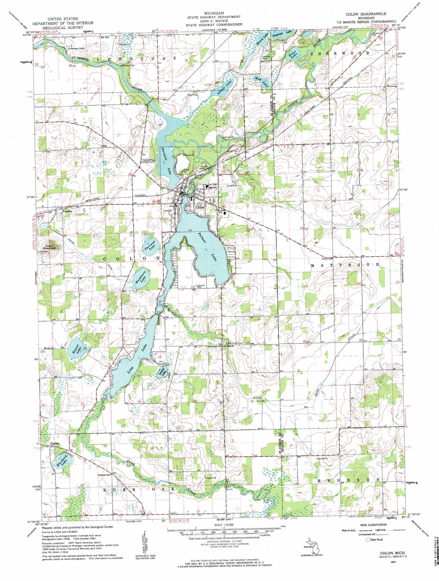
USGS Topo Quad 41085h3 - 1:24,000 scale
| Topo Map Name: | Colon |
| USGS Topo Quad ID: | 41085h3 |
| Print Size: | ca. 21 1/4" wide x 27" high |
| Southeast Coordinates: | 41.875° N latitude / 85.25° W longitude |
| Map Center Coordinates: | 41.9375° N latitude / 85.3125° W longitude |
| U.S. State: | MI |
| Filename: | o41085h3.jpg |
| Download Map JPG Image: | Colon topo map 1:24,000 scale |
| Map Type: | Topographic |
| Topo Series: | 7.5´ |
| Map Scale: | 1:24,000 |
| Source of Map Images: | United States Geological Survey (USGS) |
| Alternate Map Versions: |
Colon MI 1961, updated 1962 Download PDF Buy paper map Colon MI 1961, updated 1962 Download PDF Buy paper map Colon MI 2011 Download PDF Buy paper map Colon MI 2014 Download PDF Buy paper map Colon MI 2016 Download PDF Buy paper map |
1:24,000 Topo Quads surrounding Colon
Portage |
Adams Park |
Climax |
East Leroy |
Ellis Corners |
Vicksburg |
Mendon |
Leonidas |
Union City |
Burlington |
Three Rivers East |
Nottawa |
Colon |
Bronson North |
Coldwater West |
Klinger Lake |
Sturgis |
Burr Oak |
Bronson South |
Kinderhook |
Shipshewana |
Lagrange |
Mongo |
Orland |
Angola West |
> Back to 41085e1 at 1:100,000 scale
> Back to 41084a1 at 1:250,000 scale
> Back to U.S. Topo Maps home
Colon topo map: Gazetteer
Colon: Canals
Colon Ditch elevation 261m 856′Colon: Lakes
Adams Lake elevation 255m 836′Beaver Lake elevation 260m 853′
Big Wells Lake elevation 255m 836′
Eberhard Lake elevation 260m 853′
Farrand Lake elevation 260m 853′
Goodrich Lake elevation 255m 836′
Havens Lake elevation 255m 836′
Lepley Lake elevation 257m 843′
Little Wells Lake elevation 255m 836′
Long Lake elevation 259m 849′
Mud Lake elevation 257m 843′
Palmer Lake elevation 259m 849′
River Lake elevation 256m 839′
Sturgeon Lake elevation 255m 836′
Washburn Lake elevation 260m 853′
Colon: Parks
Colon Historical Marker elevation 264m 866′Colon Township Library Historical Marker elevation 264m 866′
Harry Blackstone Historical Marker elevation 264m 866′
Palmer Lake Beach elevation 260m 853′
Colon: Populated Places
Colon elevation 263m 862′Fairfax elevation 261m 856′
Findley elevation 262m 859′
Washburn Lake Village Mobile Home Park elevation 261m 856′
Colon: Post Offices
Colon Post Office elevation 264m 866′Fairfax Post Office (historical) elevation 261m 856′
Findley Post Office (historical) elevation 262m 859′
Colon: Streams
Little Swan Creek elevation 259m 849′Swan Creek elevation 256m 839′
Colon: Summits
Colon Mountain elevation 287m 941′Colon digital topo map on disk
Buy this Colon topo map showing relief, roads, GPS coordinates and other geographical features, as a high-resolution digital map file on DVD:
Northern Illinois, Northern Indiana & Southwestern Michigan
Buy digital topo maps: Northern Illinois, Northern Indiana & Southwestern Michigan