Jones Topo Map Michigan
To zoom in, hover over the map of Jones
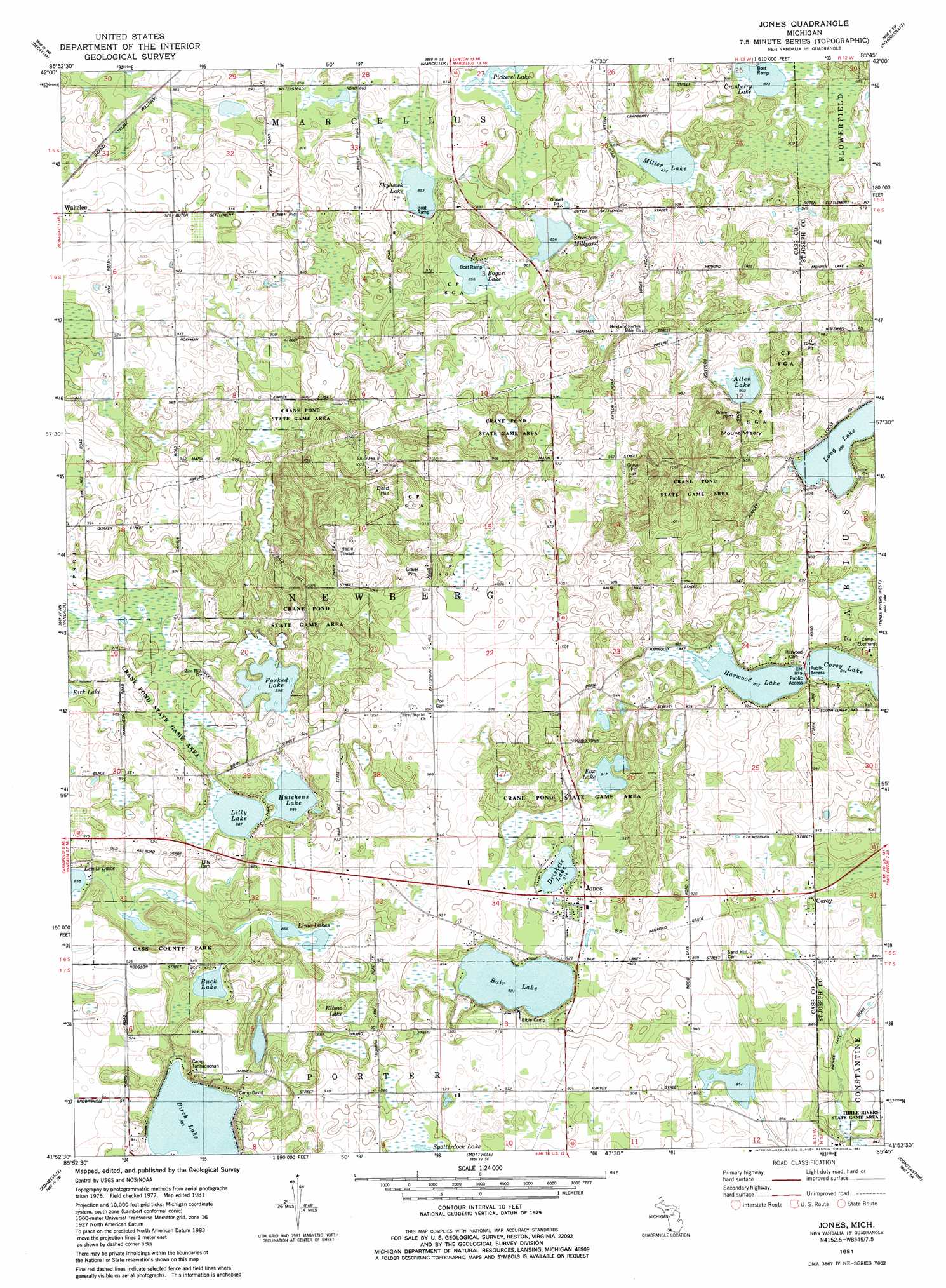
USGS Topo Quad 41085h7 - 1:24,000 scale
| Topo Map Name: | Jones |
| USGS Topo Quad ID: | 41085h7 |
| Print Size: | ca. 21 1/4" wide x 27" high |
| Southeast Coordinates: | 41.875° N latitude / 85.75° W longitude |
| Map Center Coordinates: | 41.9375° N latitude / 85.8125° W longitude |
| U.S. State: | MI |
| Filename: | o41085h7.jpg |
| Download Map JPG Image: | Jones topo map 1:24,000 scale |
| Map Type: | Topographic |
| Topo Series: | 7.5´ |
| Map Scale: | 1:24,000 |
| Source of Map Images: | United States Geological Survey (USGS) |
| Alternate Map Versions: |
Jones MI 1981, updated 1982 Download PDF Buy paper map Jones MI 2011 Download PDF Buy paper map Jones MI 2014 Download PDF Buy paper map Jones MI 2016 Download PDF Buy paper map |
1:24,000 Topo Quads surrounding Jones
Lawrence |
Paw Paw |
Lawton |
Schoolcraft Nw |
Portage |
Twin Lakes |
Decatur |
Marcellus |
Schoolcraft |
Vicksburg |
Dowagiac |
Vandalia |
Jones |
Three Rivers West |
Three Rivers East |
Edwardsburg |
Adamsville |
Mottville |
Constantine |
Klinger Lake |
Osceola |
Elkhart |
Bristol |
Middlebury |
Shipshewana |
> Back to 41085e1 at 1:100,000 scale
> Back to 41084a1 at 1:250,000 scale
> Back to U.S. Topo Maps home
Jones topo map: Gazetteer
Jones: Lakes
Allen Lake elevation 275m 902′Bair Lake elevation 268m 879′
Birch Lake elevation 260m 853′
Bogart Lake elevation 261m 856′
Buck Lake elevation 267m 875′
Cranberry Lake elevation 266m 872′
Driskels Lake elevation 278m 912′
Elbow Lake elevation 267m 875′
Fox Lake elevation 279m 915′
Harwood Lake elevation 267m 875′
Hutchens Lake elevation 271m 889′
Lewis Lake elevation 261m 856′
Lilly Lake elevation 270m 885′
Lime Lakes elevation 264m 866′
Mill Lake elevation 267m 875′
Skyhawk Lake elevation 260m 853′
Streaters Mill Pond elevation 261m 856′
Jones: Levees
Camelot Camp Grounds elevation 270m 885′Jones: Parks
Cass County Park elevation 284m 931′Crane Pond State Game Area elevation 297m 974′
Poe's Corners Historical Marker elevation 302m 990′
Jones: Populated Places
Corey elevation 269m 882′Jones elevation 281m 921′
Jones: Post Offices
Corey Post Office (historical) elevation 269m 882′Jones Post Office elevation 280m 918′
Jones: Summits
Bald Hill elevation 334m 1095′Mount Misery elevation 317m 1040′
Jones: Swamps
Forked Lake elevation 274m 898′Jones digital topo map on disk
Buy this Jones topo map showing relief, roads, GPS coordinates and other geographical features, as a high-resolution digital map file on DVD:
Northern Illinois, Northern Indiana & Southwestern Michigan
Buy digital topo maps: Northern Illinois, Northern Indiana & Southwestern Michigan