Vandalia Topo Map Michigan
To zoom in, hover over the map of Vandalia
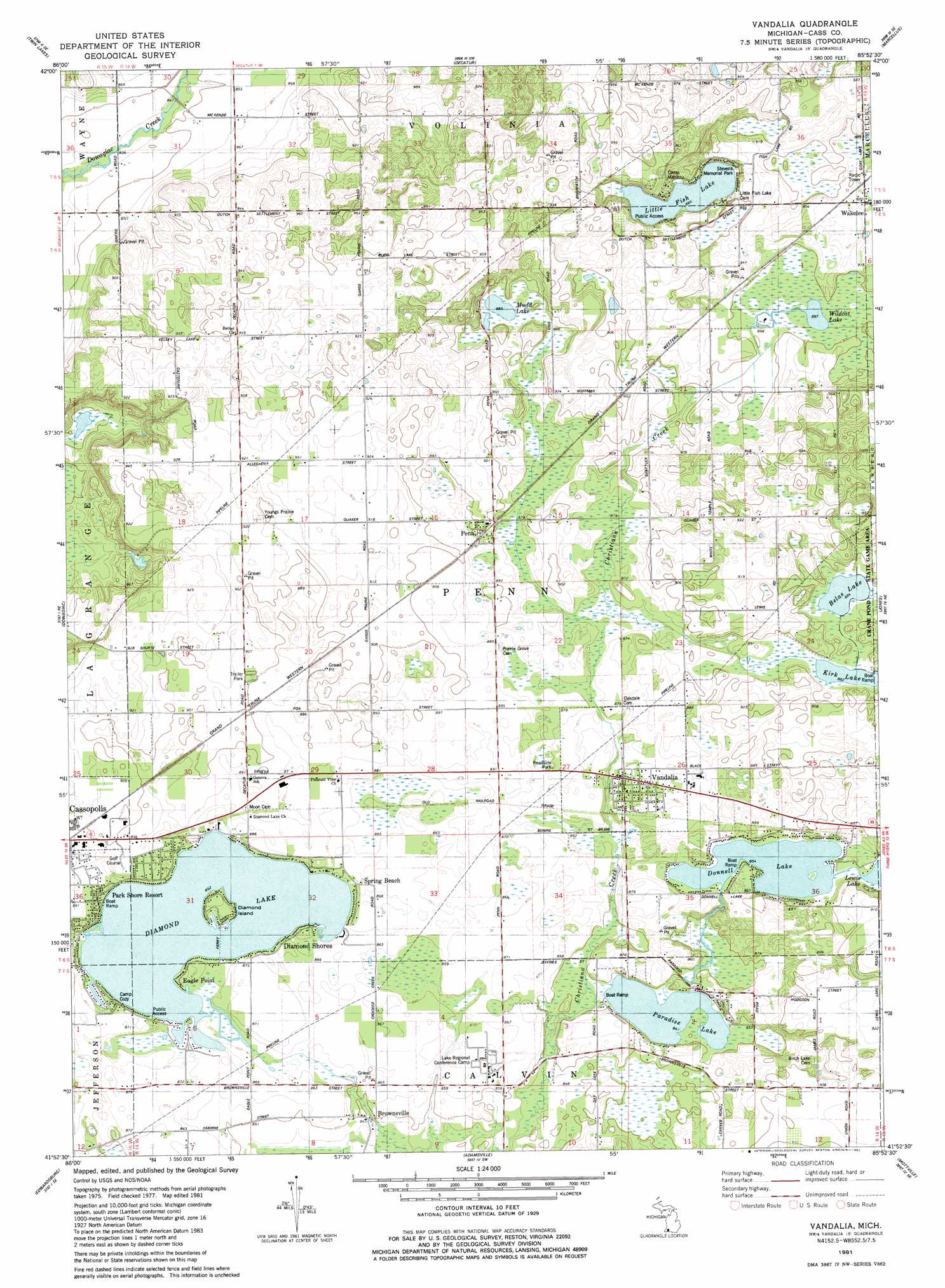
USGS Topo Quad 41085h8 - 1:24,000 scale
| Topo Map Name: | Vandalia |
| USGS Topo Quad ID: | 41085h8 |
| Print Size: | ca. 21 1/4" wide x 27" high |
| Southeast Coordinates: | 41.875° N latitude / 85.875° W longitude |
| Map Center Coordinates: | 41.9375° N latitude / 85.9375° W longitude |
| U.S. State: | MI |
| Filename: | o41085h8.jpg |
| Download Map JPG Image: | Vandalia topo map 1:24,000 scale |
| Map Type: | Topographic |
| Topo Series: | 7.5´ |
| Map Scale: | 1:24,000 |
| Source of Map Images: | United States Geological Survey (USGS) |
| Alternate Map Versions: |
Vandalia MI 1981, updated 1982 Download PDF Buy paper map Vandalia MI 2011 Download PDF Buy paper map Vandalia MI 2014 Download PDF Buy paper map Vandalia MI 2016 Download PDF Buy paper map |
1:24,000 Topo Quads surrounding Vandalia
Hartford |
Lawrence |
Paw Paw |
Lawton |
Schoolcraft Nw |
Sister Lakes |
Twin Lakes |
Decatur |
Marcellus |
Schoolcraft |
Sumnerville |
Dowagiac |
Vandalia |
Jones |
Three Rivers West |
Niles East |
Edwardsburg |
Adamsville |
Mottville |
Constantine |
South Bend East |
Osceola |
Elkhart |
Bristol |
Middlebury |
> Back to 41085e1 at 1:100,000 scale
> Back to 41084a1 at 1:250,000 scale
> Back to U.S. Topo Maps home
Vandalia topo map: Gazetteer
Vandalia: Islands
Diamond Island elevation 262m 859′Vandalia: Lakes
Belas Lake elevation 270m 885′Diamond Lake elevation 262m 859′
Donnell Lake elevation 260m 853′
Kirk Lake elevation 270m 885′
Little Fish Lake elevation 273m 895′
Muld Lake elevation 270m 885′
Paradise Lake elevation 257m 843′
Wildcat Lake elevation 273m 895′
Vandalia: Parks
Bonine Elk Park elevation 265m 869′Stevens Memorial Park elevation 274m 898′
Underground Railroad Historical Marker elevation 265m 869′
Vandalia: Populated Places
Brownsville elevation 256m 839′Diamond Shores elevation 265m 869′
Eagle Point elevation 262m 859′
Maple Grove Trailer Park elevation 276m 905′
Penn elevation 275m 902′
Spring Beach elevation 266m 872′
Vandalia elevation 268m 879′
Wakelee elevation 278m 912′
Vandalia: Post Offices
Brownsville Post Office (historical) elevation 256m 839′Penn Post Office (historical) elevation 275m 902′
Vandalia Post Office elevation 271m 889′
Wakelee Post Office (historical) elevation 278m 912′
Vandalia digital topo map on disk
Buy this Vandalia topo map showing relief, roads, GPS coordinates and other geographical features, as a high-resolution digital map file on DVD:
Northern Illinois, Northern Indiana & Southwestern Michigan
Buy digital topo maps: Northern Illinois, Northern Indiana & Southwestern Michigan