Pershing Topo Map Indiana
To zoom in, hover over the map of Pershing
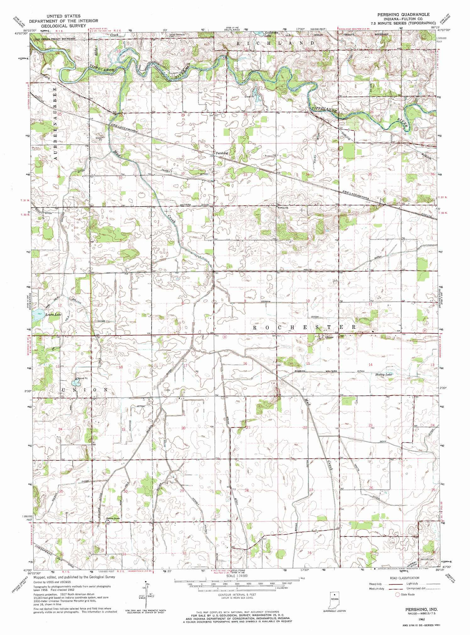
USGS Topo Quad 41086a3 - 1:24,000 scale
| Topo Map Name: | Pershing |
| USGS Topo Quad ID: | 41086a3 |
| Print Size: | ca. 21 1/4" wide x 27" high |
| Southeast Coordinates: | 41° N latitude / 86.25° W longitude |
| Map Center Coordinates: | 41.0625° N latitude / 86.3125° W longitude |
| U.S. State: | IN |
| Filename: | o41086a3.jpg |
| Download Map JPG Image: | Pershing topo map 1:24,000 scale |
| Map Type: | Topographic |
| Topo Series: | 7.5´ |
| Map Scale: | 1:24,000 |
| Source of Map Images: | United States Geological Survey (USGS) |
| Alternate Map Versions: |
Pershing IN 1962, updated 1964 Download PDF Buy paper map Pershing IN 2010 Download PDF Buy paper map Pershing IN 2013 Download PDF Buy paper map Pershing IN 2016 Download PDF Buy paper map |
1:24,000 Topo Quads surrounding Pershing
Knox East |
Donaldson |
Plymouth |
Inwood |
Bourbon |
Bass Lake |
Culver |
Rutland |
Argos |
Mentone |
Winamac |
Kewanna |
Pershing |
Rochester |
Akron |
Star City |
Grass Creek |
Fulton |
Macy |
Deedsville |
Burnettsville |
Lucerne |
Logansport |
Twelve Mile |
Peru |
> Back to 41086a1 at 1:100,000 scale
> Back to 41086a1 at 1:250,000 scale
> Back to U.S. Topo Maps home
Pershing topo map: Gazetteer
Pershing: Canals
Allen Ditch elevation 228m 748′Baker Ditch elevation 232m 761′
Cessna Ditch elevation 230m 754′
Collins Ditch elevation 229m 751′
Collins Ditch Arm Number Four elevation 227m 744′
Collins Ditch Arm Number Three elevation 229m 751′
Collins Ditch Arm Number Two elevation 228m 748′
Grube Ditch elevation 231m 757′
Holtz Ditch elevation 231m 757′
Hudkins Ditch elevation 228m 748′
Kersey Finney Ditch elevation 232m 761′
Mathias Ditch elevation 227m 744′
Miller Ditch elevation 231m 757′
Robbins Walters Ditch elevation 230m 754′
Steinke Ditch elevation 232m 761′
Tilden Ditch elevation 226m 741′
White Ditch elevation 232m 761′
Wilson Ditch elevation 230m 754′
Wilson Ditch Arm Number Two elevation 231m 757′
Pershing: Lakes
Lears Lake elevation 226m 741′Shakey Lake elevation 229m 751′
Pershing: Populated Places
Pershing elevation 229m 751′Pershing: Streams
Eddy Creek elevation 222m 728′Mud Creek elevation 225m 738′
Pershing digital topo map on disk
Buy this Pershing topo map showing relief, roads, GPS coordinates and other geographical features, as a high-resolution digital map file on DVD:
Northern Illinois, Northern Indiana & Southwestern Michigan
Buy digital topo maps: Northern Illinois, Northern Indiana & Southwestern Michigan