Winamac Topo Map Indiana
To zoom in, hover over the map of Winamac
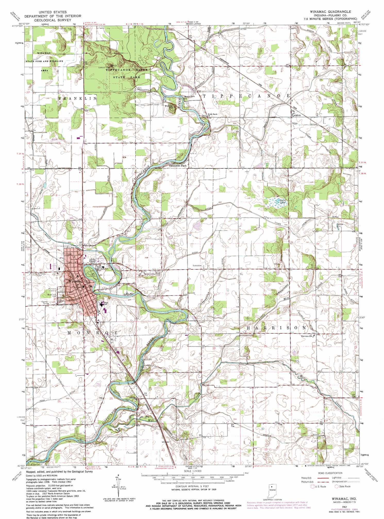
USGS Topo Quad 41086a5 - 1:24,000 scale
| Topo Map Name: | Winamac |
| USGS Topo Quad ID: | 41086a5 |
| Print Size: | ca. 21 1/4" wide x 27" high |
| Southeast Coordinates: | 41° N latitude / 86.5° W longitude |
| Map Center Coordinates: | 41.0625° N latitude / 86.5625° W longitude |
| U.S. State: | IN |
| Filename: | o41086a5.jpg |
| Download Map JPG Image: | Winamac topo map 1:24,000 scale |
| Map Type: | Topographic |
| Topo Series: | 7.5´ |
| Map Scale: | 1:24,000 |
| Source of Map Images: | United States Geological Survey (USGS) |
| Alternate Map Versions: |
Winamac IN 1962, updated 1964 Download PDF Buy paper map Winamac IN 1962, updated 1980 Download PDF Buy paper map Winamac IN 2010 Download PDF Buy paper map Winamac IN 2013 Download PDF Buy paper map Winamac IN 2016 Download PDF Buy paper map |
1:24,000 Topo Quads surrounding Winamac
English Lake |
Knox West |
Knox East |
Donaldson |
Plymouth |
North Judson |
Denham |
Bass Lake |
Culver |
Rutland |
North Judson Se |
Ripley |
Winamac |
Kewanna |
Pershing |
Monon Ne |
Buffalo |
Star City |
Grass Creek |
Fulton |
Monticello North |
Idaville |
Burnettsville |
Lucerne |
Logansport |
> Back to 41086a1 at 1:100,000 scale
> Back to 41086a1 at 1:250,000 scale
> Back to U.S. Topo Maps home
Winamac topo map: Gazetteer
Winamac: Airports
Arens Field elevation 216m 708′Winamac: Canals
Anstis Ditch elevation 220m 721′Breckenridge Ditch elevation 220m 721′
Bruce Lake Outlet elevation 219m 718′
Graffis Ditch elevation 220m 721′
Haschel Ditch elevation 215m 705′
James Ditch elevation 222m 728′
Kessi Ditch elevation 218m 715′
Leidendecker Ditch elevation 215m 705′
Miller Ditch elevation 221m 725′
Reinhold Ditch elevation 214m 702′
Stone Dilts Ditch elevation 216m 708′
Thompson Ditch elevation 213m 698′
Tyler Weisjahn Ditch elevation 216m 708′
Wilhelm Ditch elevation 219m 718′
Winamac: Lakes
Devil Lake elevation 217m 711′Winamac: Parks
Beason Park elevation 213m 698′Camp Paxton elevation 210m 688′
Winamac State Fish and Wildlife Area elevation 218m 715′
Winamac: Populated Places
Lawton elevation 218m 715′Vanmeter Park elevation 217m 711′
Winamac elevation 215m 705′
Winamac: Streams
Little Mill Creek elevation 213m 698′Mill Creek elevation 205m 672′
Winamac: Summits
Bunker Hill elevation 233m 764′Winamac digital topo map on disk
Buy this Winamac topo map showing relief, roads, GPS coordinates and other geographical features, as a high-resolution digital map file on DVD:
Northern Illinois, Northern Indiana & Southwestern Michigan
Buy digital topo maps: Northern Illinois, Northern Indiana & Southwestern Michigan