Knox West Topo Map Indiana
To zoom in, hover over the map of Knox West
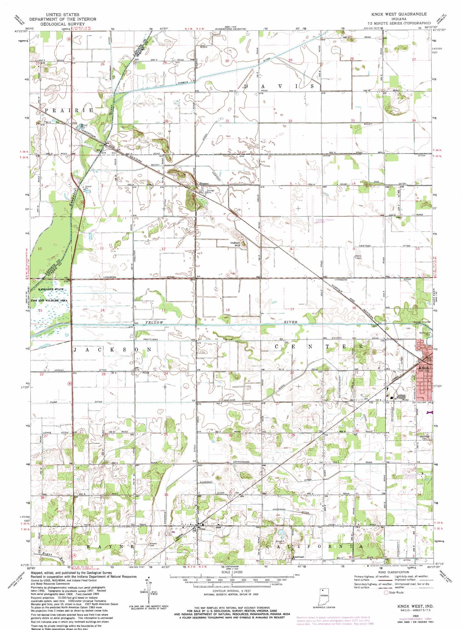
USGS Topo Quad 41086c6 - 1:24,000 scale
| Topo Map Name: | Knox West |
| USGS Topo Quad ID: | 41086c6 |
| Print Size: | ca. 21 1/4" wide x 27" high |
| Southeast Coordinates: | 41.25° N latitude / 86.625° W longitude |
| Map Center Coordinates: | 41.3125° N latitude / 86.6875° W longitude |
| U.S. State: | IN |
| Filename: | o41086c6.jpg |
| Download Map JPG Image: | Knox West topo map 1:24,000 scale |
| Map Type: | Topographic |
| Topo Series: | 7.5´ |
| Map Scale: | 1:24,000 |
| Source of Map Images: | United States Geological Survey (USGS) |
| Alternate Map Versions: |
Knox West IN 1957, updated 1959 Download PDF Buy paper map Knox West IN 1969, updated 1971 Download PDF Buy paper map Knox West IN 1969, updated 1980 Download PDF Buy paper map Knox West IN 2010 Download PDF Buy paper map Knox West IN 2013 Download PDF Buy paper map Knox West IN 2016 Download PDF Buy paper map |
1:24,000 Topo Quads surrounding Knox West
Westville |
Laporte West |
Laporte East |
Stillwell |
North Liberty |
Wanatah |
Hanna |
Kingsford Heights |
Hamlet |
Walkerton |
La Crosse |
English Lake |
Knox West |
Knox East |
Donaldson |
San Pierre |
North Judson |
Denham |
Bass Lake |
Culver |
Medaryville |
North Judson Se |
Ripley |
Winamac |
Kewanna |
> Back to 41086a1 at 1:100,000 scale
> Back to 41086a1 at 1:250,000 scale
> Back to U.S. Topo Maps home
Knox West topo map: Gazetteer
Knox West: Airports
Singletons Landing Strip elevation 209m 685′Starke County Airport elevation 209m 685′
Wilson Airport elevation 218m 715′
Knox West: Canals
Anderson Ditch elevation 211m 692′Bailey Ditch elevation 208m 682′
Cavanaugh Ditch elevation 214m 702′
Cottonwood Ditch elevation 215m 705′
Cox Ditch elevation 209m 685′
Jackson-Shilling Ditch elevation 212m 695′
Kreuter Ditch elevation 205m 672′
Laramore Ditch elevation 205m 672′
Lindstrand Ditch elevation 216m 708′
Newtson Ditch elevation 208m 682′
Prettyman Ditch elevation 204m 669′
Williams Ditch elevation 207m 679′
Knox West: Populated Places
Brems elevation 207m 679′Indian Hill elevation 208m 682′
Knox elevation 217m 711′
Toto elevation 216m 708′
Knox West digital topo map on disk
Buy this Knox West topo map showing relief, roads, GPS coordinates and other geographical features, as a high-resolution digital map file on DVD:
Northern Illinois, Northern Indiana & Southwestern Michigan
Buy digital topo maps: Northern Illinois, Northern Indiana & Southwestern Michigan