Walkerton Topo Map Indiana
To zoom in, hover over the map of Walkerton
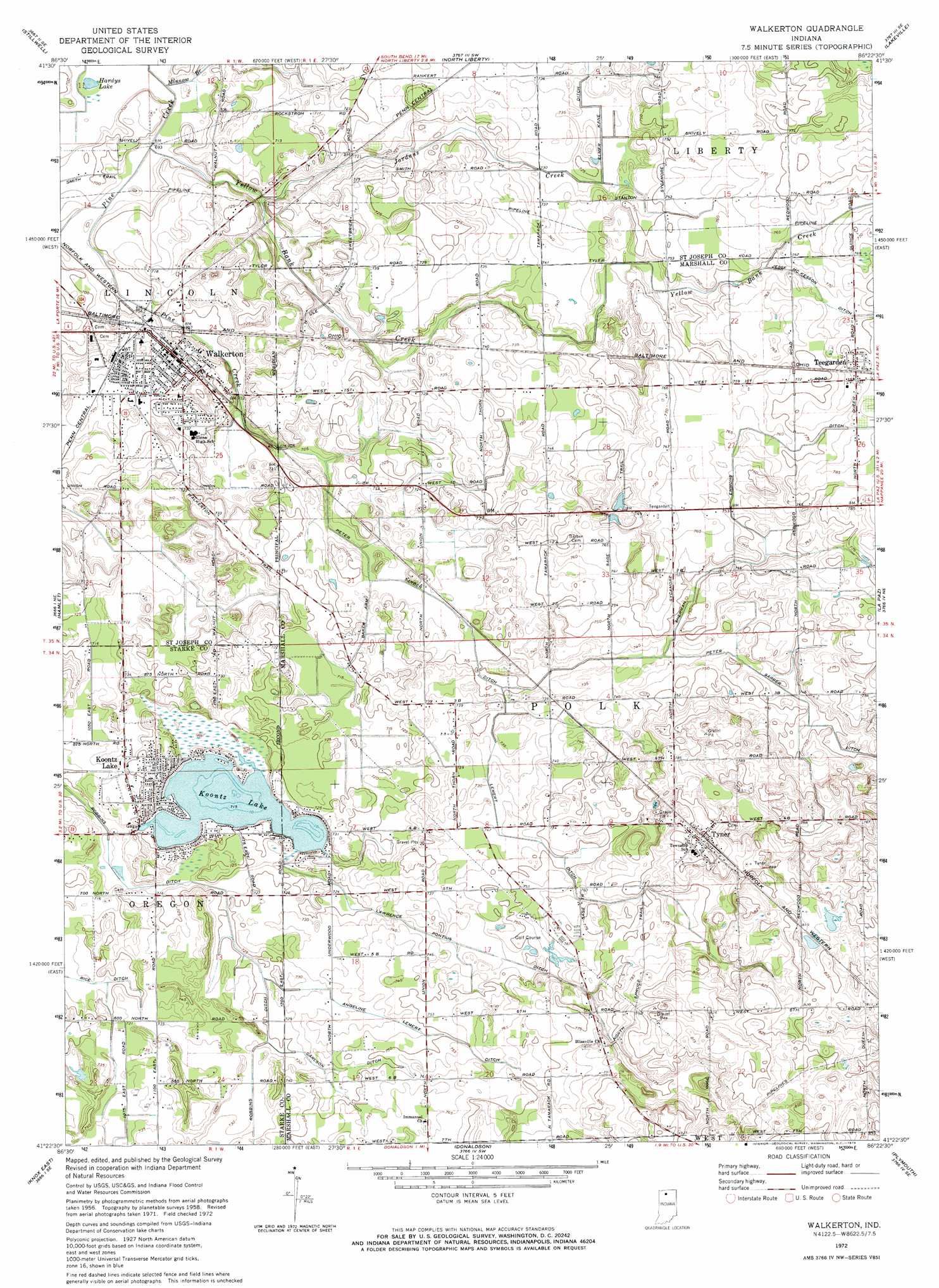
USGS Topo Quad 41086d4 - 1:24,000 scale
| Topo Map Name: | Walkerton |
| USGS Topo Quad ID: | 41086d4 |
| Print Size: | ca. 21 1/4" wide x 27" high |
| Southeast Coordinates: | 41.375° N latitude / 86.375° W longitude |
| Map Center Coordinates: | 41.4375° N latitude / 86.4375° W longitude |
| U.S. State: | IN |
| Filename: | o41086d4.jpg |
| Download Map JPG Image: | Walkerton topo map 1:24,000 scale |
| Map Type: | Topographic |
| Topo Series: | 7.5´ |
| Map Scale: | 1:24,000 |
| Source of Map Images: | United States Geological Survey (USGS) |
| Alternate Map Versions: |
Walkerton IN 1958, updated 1960 Download PDF Buy paper map Walkerton IN 1972, updated 1974 Download PDF Buy paper map Walkerton IN 2010 Download PDF Buy paper map Walkerton IN 2013 Download PDF Buy paper map Walkerton IN 2016 Download PDF Buy paper map |
1:24,000 Topo Quads surrounding Walkerton
Springville |
New Carlisle |
Lydick |
South Bend West |
South Bend East |
Laporte East |
Stillwell |
North Liberty |
Lakeville |
Wyatt |
Kingsford Heights |
Hamlet |
Walkerton |
La Paz |
Bremen |
Knox West |
Knox East |
Donaldson |
Plymouth |
Inwood |
Denham |
Bass Lake |
Culver |
Rutland |
Argos |
> Back to 41086a1 at 1:100,000 scale
> Back to 41086a1 at 1:250,000 scale
> Back to U.S. Topo Maps home
Walkerton topo map: Gazetteer
Walkerton: Airports
Stuntz and Hochstetler Pines Airport elevation 225m 738′Walkerton: Canals
Angeline Lemert Ditch elevation 225m 738′Baker Arm elevation 218m 715′
Carlson Ditch elevation 225m 738′
Elmer Kane Ditch elevation 222m 728′
Lawrence Pontius Ditch elevation 225m 738′
Lemert Ditch elevation 227m 744′
Peter Sarber Ditch elevation 222m 728′
Sherman Emmons Ditch elevation 233m 764′
Walkerton: Dams
Koontz Lake Dam elevation 220m 721′Walkerton: Lakes
Hardys Lake elevation 208m 682′Walkerton: Populated Places
Carmel (historical) elevation 231m 757′Koontz Lake elevation 223m 731′
Teegarden elevation 240m 787′
Tyner elevation 242m 793′
Walkerton elevation 221m 725′
Walkerton: Reservoirs
Koontz Lake elevation 220m 721′Walkerton: Streams
Jordans Creek elevation 216m 708′Minnow Branch elevation 212m 695′
South Branch Pine Creek elevation 224m 734′
Yellow Bank Creek elevation 211m 692′
Walkerton digital topo map on disk
Buy this Walkerton topo map showing relief, roads, GPS coordinates and other geographical features, as a high-resolution digital map file on DVD:
Northern Illinois, Northern Indiana & Southwestern Michigan
Buy digital topo maps: Northern Illinois, Northern Indiana & Southwestern Michigan