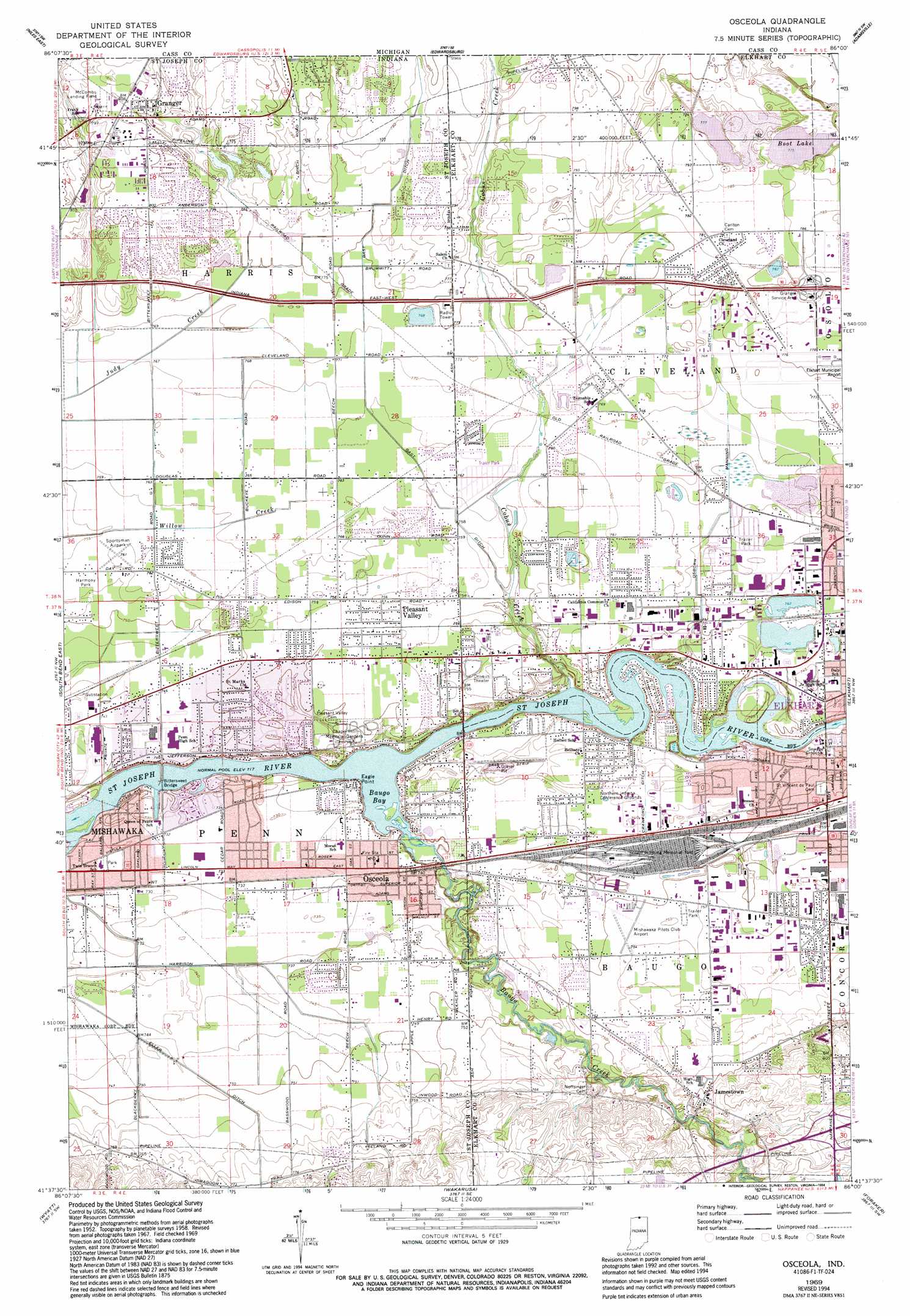
Osceola Topo Map Indiana
To zoom in, hover over the map of Osceola
USGS Topo Quad 41086f1 - 1:24,000 scale
| Topo Map Name: | Osceola |
| USGS Topo Quad ID: | 41086f1 |
| Print Size: | ca. 21 1/4" wide x 27" high |
| Southeast Coordinates: | 41.625° N latitude / 86° W longitude |
| Map Center Coordinates: | 41.6875° N latitude / 86.0625° W longitude |
| U.S. State: | IN |
| Filename: | o41086f1.jpg |
| Download Map JPG Image: | Osceola topo map 1:24,000 scale |
| Map Type: | Topographic |
| Topo Series: | 7.5´ |
| Map Scale: | 1:24,000 |
| Source of Map Images: | United States Geological Survey (USGS) |
| Alternate Map Versions: |
Osceola IN 1958, updated 1960 Download PDF Buy paper map Osceola IN 1969, updated 1971 Download PDF Buy paper map Osceola IN 1969, updated 1980 Download PDF Buy paper map Osceola IN 1969, updated 1987 Download PDF Buy paper map Osceola IN 1969, updated 1994 Download PDF Buy paper map Osceola IN 2011 Download PDF Buy paper map Osceola IN 2013 Download PDF Buy paper map Osceola IN 2016 Download PDF Buy paper map |
1:24,000 Topo Quads surrounding Osceola
Berrien Springs |
Sumnerville |
Dowagiac |
Vandalia |
Jones |
Niles West |
Niles East |
Edwardsburg |
Adamsville |
Mottville |
South Bend West |
South Bend East |
Osceola |
Elkhart |
Bristol |
Lakeville |
Wyatt |
Wakarusa |
Foraker |
Goshen |
La Paz |
Bremen |
Nappanee West |
Nappanee East |
Milford |
> Back to 41086e1 at 1:100,000 scale
> Back to 41086a1 at 1:250,000 scale
> Back to U.S. Topo Maps home
Osceola topo map: Gazetteer
Osceola: Airports
Cam-Air Airport elevation 236m 774′Foos Field elevation 241m 790′
Mishawaka Pilots Club Airport elevation 229m 751′
Osceola: Bays
Baugo Bay elevation 219m 718′Osceola: Bridges
Bittersweet Bridge elevation 223m 731′Bittersweet Bridge elevation 222m 728′
Osceola: Canals
Crawford Ditch elevation 226m 741′Eller Ditch elevation 225m 738′
Eller Ditch elevation 227m 744′
Gast Ditch elevation 235m 770′
Osborn Manning Ditch elevation 232m 761′
Osceola: Capes
Eagle Point elevation 219m 718′Osceola: Lakes
Boot Lake elevation 236m 774′Osceola: Parks
Harmony Park elevation 231m 757′Osceola: Populated Places
Jamestown elevation 237m 777′Osceola elevation 225m 738′
Pleasant Valley elevation 230m 754′
Osceola: Streams
Baugo Creek elevation 218m 715′Cobus Creek elevation 220m 721′
Osceola digital topo map on disk
Buy this Osceola topo map showing relief, roads, GPS coordinates and other geographical features, as a high-resolution digital map file on DVD:
Northern Illinois, Northern Indiana & Southwestern Michigan
Buy digital topo maps: Northern Illinois, Northern Indiana & Southwestern Michigan