South Bend West Topo Map Indiana
To zoom in, hover over the map of South Bend West
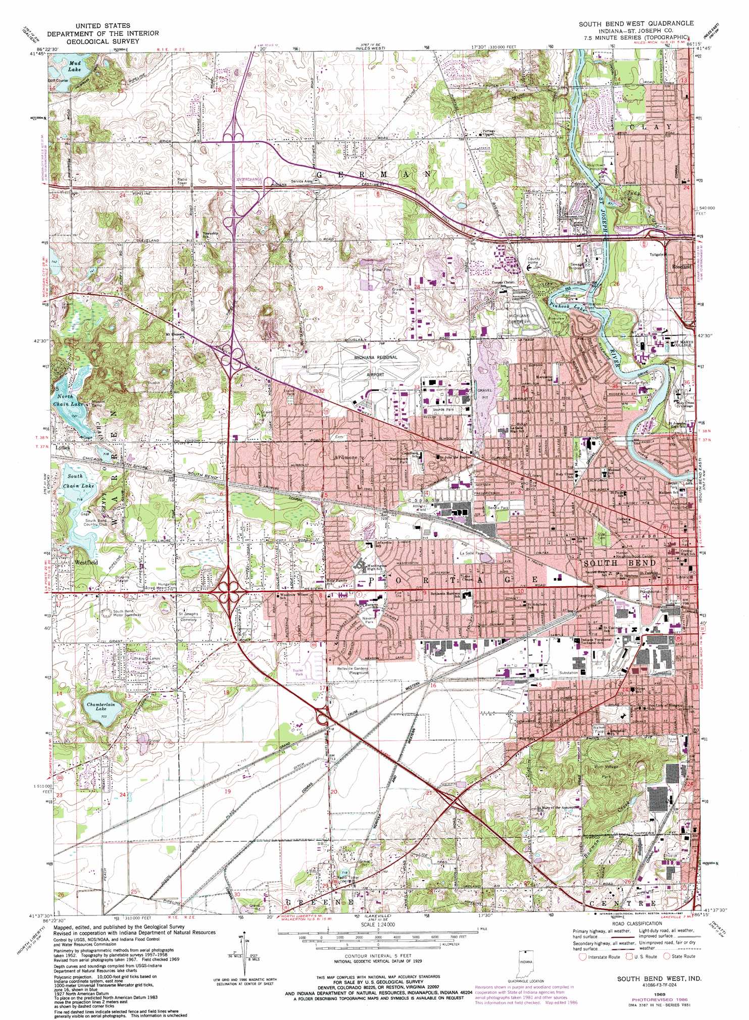
USGS Topo Quad 41086f3 - 1:24,000 scale
| Topo Map Name: | South Bend West |
| USGS Topo Quad ID: | 41086f3 |
| Print Size: | ca. 21 1/4" wide x 27" high |
| Southeast Coordinates: | 41.625° N latitude / 86.25° W longitude |
| Map Center Coordinates: | 41.6875° N latitude / 86.3125° W longitude |
| U.S. State: | IN |
| Filename: | o41086f3.jpg |
| Download Map JPG Image: | South Bend West topo map 1:24,000 scale |
| Map Type: | Topographic |
| Topo Series: | 7.5´ |
| Map Scale: | 1:24,000 |
| Source of Map Images: | United States Geological Survey (USGS) |
| Alternate Map Versions: |
South Bend West IN 1958, updated 1959 Download PDF Buy paper map South Bend West IN 1969, updated 1971 Download PDF Buy paper map South Bend West IN 1969, updated 1980 Download PDF Buy paper map South Bend West IN 1969, updated 1987 Download PDF Buy paper map South Bend West IN 1969, updated 1987 Download PDF Buy paper map South Bend West IN 2010 Download PDF Buy paper map South Bend West IN 2013 Download PDF Buy paper map South Bend West IN 2016 Download PDF Buy paper map |
1:24,000 Topo Quads surrounding South Bend West
Bridgman |
Baroda |
Berrien Springs |
Sumnerville |
Dowagiac |
Three Oaks |
Galien |
Niles West |
Niles East |
Edwardsburg |
New Carlisle |
Lydick |
South Bend West |
South Bend East |
Osceola |
Stillwell |
North Liberty |
Lakeville |
Wyatt |
Wakarusa |
Hamlet |
Walkerton |
La Paz |
Bremen |
Nappanee West |
> Back to 41086e1 at 1:100,000 scale
> Back to 41086a1 at 1:250,000 scale
> Back to U.S. Topo Maps home
South Bend West topo map: Gazetteer
South Bend West: Airports
Chain-O-Lakes Airport elevation 226m 741′McClures Airport elevation 247m 810′
Michiana Regional Airport elevation 234m 767′
South Bend West: Crossings
Interchange 8 elevation 221m 725′South Bend West: Lakes
Chain O' Lakes elevation 219m 718′Chamberlain Lake elevation 218m 715′
Mud Lake elevation 228m 748′
North Chain Lake elevation 220m 721′
Pinhook Lake elevation 203m 666′
South Chain Lake elevation 218m 715′
South Bend West: Parks
Belleville Gardens Playground elevation 218m 715′Bendix Park elevation 217m 711′
Harrison Park elevation 218m 715′
Kaiser Park elevation 237m 777′
Keller Park elevation 205m 672′
La Salle Park elevation 221m 725′
Leeper Park elevation 209m 685′
Muessel Grove Park elevation 216m 708′
Navarre Park elevation 220m 721′
Pinhook Park elevation 206m 675′
Rum Village Park elevation 236m 774′
Voorde Park elevation 232m 761′
Walker Field elevation 241m 790′
Westhaven Park elevation 223m 731′
South Bend West: Populated Places
Ardmore elevation 226m 741′Roseland elevation 222m 728′
South Bend elevation 211m 692′
South Bend West: Streams
Judy Creek elevation 202m 662′South Bend West digital topo map on disk
Buy this South Bend West topo map showing relief, roads, GPS coordinates and other geographical features, as a high-resolution digital map file on DVD:
Northern Illinois, Northern Indiana & Southwestern Michigan
Buy digital topo maps: Northern Illinois, Northern Indiana & Southwestern Michigan