Edwardsburg Topo Map Michigan
To zoom in, hover over the map of Edwardsburg
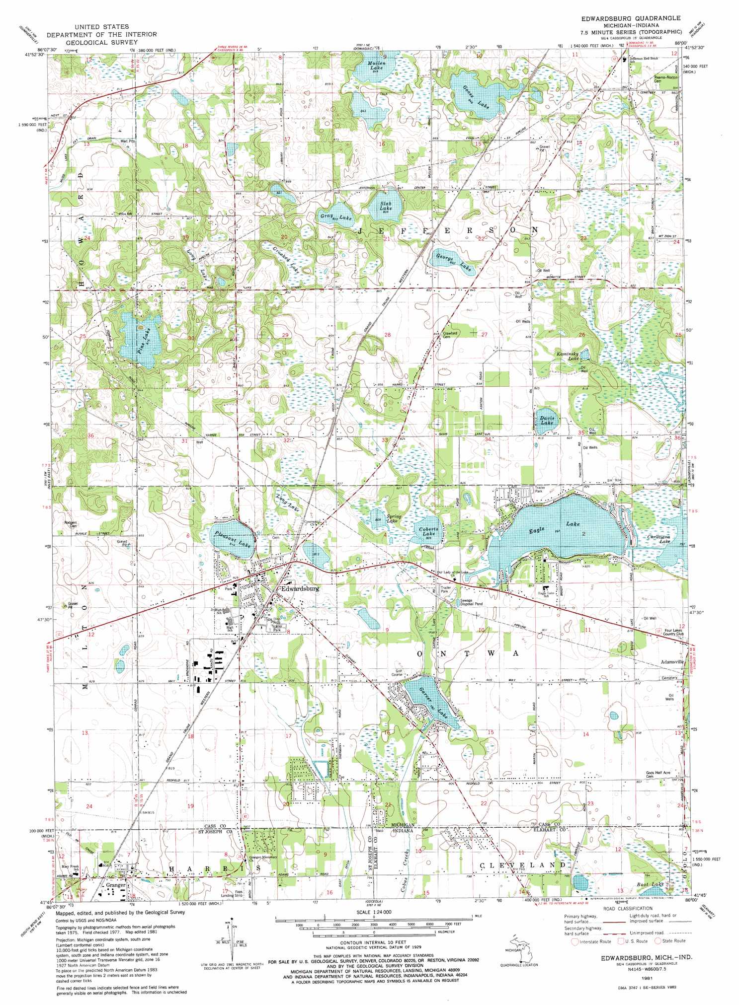
USGS Topo Quad 41086g1 - 1:24,000 scale
| Topo Map Name: | Edwardsburg |
| USGS Topo Quad ID: | 41086g1 |
| Print Size: | ca. 21 1/4" wide x 27" high |
| Southeast Coordinates: | 41.75° N latitude / 86° W longitude |
| Map Center Coordinates: | 41.8125° N latitude / 86.0625° W longitude |
| U.S. States: | MI, IN |
| Filename: | o41086g1.jpg |
| Download Map JPG Image: | Edwardsburg topo map 1:24,000 scale |
| Map Type: | Topographic |
| Topo Series: | 7.5´ |
| Map Scale: | 1:24,000 |
| Source of Map Images: | United States Geological Survey (USGS) |
| Alternate Map Versions: |
Edwardsburg MI 1981, updated 1982 Download PDF Buy paper map Edwardsburg MI 2011 Download PDF Buy paper map Edwardsburg MI 2014 Download PDF Buy paper map Edwardsburg MI 2016 Download PDF Buy paper map |
1:24,000 Topo Quads surrounding Edwardsburg
Sodus |
Sister Lakes |
Twin Lakes |
Decatur |
Marcellus |
Berrien Springs |
Sumnerville |
Dowagiac |
Vandalia |
Jones |
Niles West |
Niles East |
Edwardsburg |
Adamsville |
Mottville |
South Bend West |
South Bend East |
Osceola |
Elkhart |
Bristol |
Lakeville |
Wyatt |
Wakarusa |
Foraker |
Goshen |
> Back to 41086e1 at 1:100,000 scale
> Back to 41086a1 at 1:250,000 scale
> Back to U.S. Topo Maps home
Edwardsburg topo map: Gazetteer
Edwardsburg: Lakes
Coberts Lake elevation 244m 800′Crooked Lake elevation 251m 823′
Davis Lake elevation 244m 800′
Eagle Lake elevation 241m 790′
Garver Lake elevation 241m 790′
George Lake elevation 253m 830′
Goose Lake elevation 256m 839′
Gray Lake elevation 253m 830′
Kaminsky Lake elevation 244m 800′
Long Lake elevation 248m 813′
Mullen Lake elevation 256m 839′
Pine Lake elevation 247m 810′
Pleasant Lake elevation 247m 810′
Skab Lake elevation 253m 830′
Spring Lake elevation 244m 800′
Edwardsburg: Parks
Mueler Park elevation 252m 826′Presbyterian Church Historical Marker elevation 254m 833′
Edwardsburg: Populated Places
Colonial Acres Mobile Home Park elevation 248m 813′Eagle Lake Estates elevation 249m 816′
Edwardsburg elevation 254m 833′
Edwardsburg Mobile Home Estates elevation 252m 826′
Granger elevation 244m 800′
Edwardsburg: Post Offices
Edwardsburg Post Office elevation 255m 836′Jeffersonville Post Office (historical) elevation 260m 853′
Edwardsburg: Swamps
Long Lake elevation 248m 813′Edwardsburg digital topo map on disk
Buy this Edwardsburg topo map showing relief, roads, GPS coordinates and other geographical features, as a high-resolution digital map file on DVD:
Northern Illinois, Northern Indiana & Southwestern Michigan
Buy digital topo maps: Northern Illinois, Northern Indiana & Southwestern Michigan