Berrien Springs Topo Map Michigan
To zoom in, hover over the map of Berrien Springs
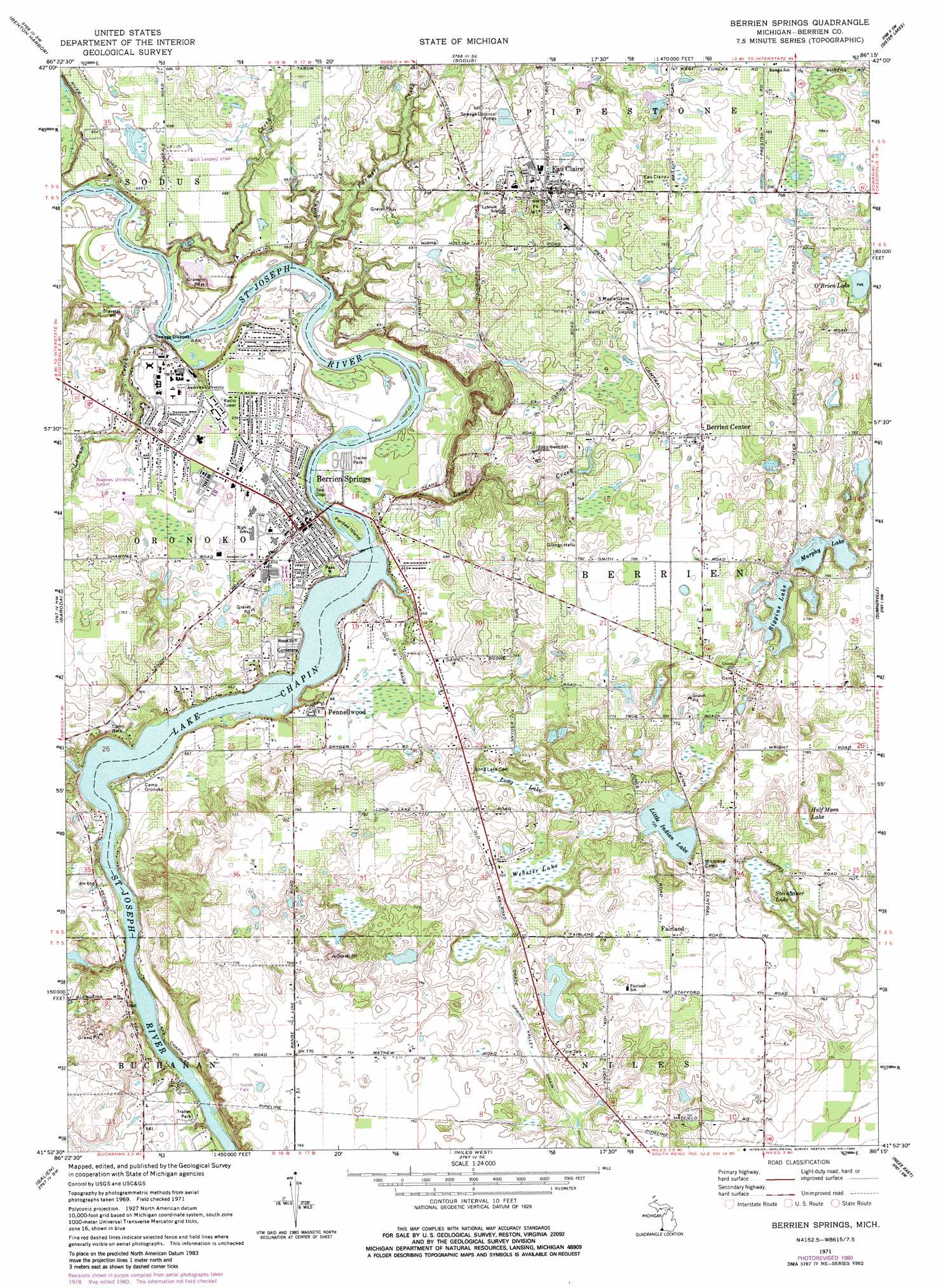
USGS Topo Quad 41086h3 - 1:24,000 scale
| Topo Map Name: | Berrien Springs |
| USGS Topo Quad ID: | 41086h3 |
| Print Size: | ca. 21 1/4" wide x 27" high |
| Southeast Coordinates: | 41.875° N latitude / 86.25° W longitude |
| Map Center Coordinates: | 41.9375° N latitude / 86.3125° W longitude |
| U.S. State: | MI |
| Filename: | o41086h3.jpg |
| Download Map JPG Image: | Berrien Springs topo map 1:24,000 scale |
| Map Type: | Topographic |
| Topo Series: | 7.5´ |
| Map Scale: | 1:24,000 |
| Source of Map Images: | United States Geological Survey (USGS) |
| Alternate Map Versions: |
Berrien Springs MI 1971, updated 1973 Download PDF Buy paper map Berrien Springs MI 1971, updated 1980 Download PDF Buy paper map Berrien Springs MI 2011 Download PDF Buy paper map Berrien Springs MI 2014 Download PDF Buy paper map Berrien Springs MI 2016 Download PDF Buy paper map |
1:24,000 Topo Quads surrounding Berrien Springs
Benton Heights |
Coloma |
Hartford |
Lawrence |
|
Stevensville |
Benton Harbor |
Sodus |
Sister Lakes |
Twin Lakes |
Bridgman |
Baroda |
Berrien Springs |
Sumnerville |
Dowagiac |
Three Oaks |
Galien |
Niles West |
Niles East |
Edwardsburg |
New Carlisle |
Lydick |
South Bend West |
South Bend East |
Osceola |
> Back to 41086e1 at 1:100,000 scale
> Back to 41086a1 at 1:250,000 scale
> Back to U.S. Topo Maps home
Berrien Springs topo map: Gazetteer
Berrien Springs: Airports
Andrews University Airpark elevation 205m 672′Berrien Springs: Islands
Pardee Island elevation 189m 620′Berrien Springs: Lakes
Little Indian Lake elevation 221m 725′Murphy Lake elevation 224m 734′
O'Brien Lake elevation 227m 744′
Riggins Lake elevation 224m 734′
Berrien Springs: Parks
Andrews University Historical Marker elevation 205m 672′Beaver Stadium elevation 213m 698′
Berrien Springs Courthouse Historical Marker elevation 205m 672′
Elizabeth Park elevation 217m 711′
Indian Fields Grove Park elevation 202m 662′
Lions Park elevation 209m 685′
Lions Park elevation 206m 675′
Love Creek County Park elevation 224m 734′
Memorial Park elevation 208m 682′
Police Memorial Park elevation 189m 620′
Railroad Park elevation 213m 698′
Rotary Park elevation 189m 620′
Shamrock Park elevation 188m 616′
Berrien Springs: Populated Places
Berrien Center elevation 234m 767′Berrien Springs elevation 205m 672′
Eau Claire elevation 214m 702′
Fairland elevation 239m 784′
Hill's Haven Mobile Home Park elevation 205m 672′
Pennellwood elevation 211m 692′
River Spring Estates elevation 204m 669′
Berrien Springs: Post Offices
Andrews Post Office (historical) elevation 205m 672′Berrien Center Post Office elevation 234m 767′
Berrien Springs Post Office elevation 206m 675′
Eau Claire Post Office elevation 216m 708′
Fairland Post Office (historical) elevation 239m 784′
Berrien Springs: Reservoirs
Lake Chapin elevation 186m 610′Berrien Springs: Streams
Farmers Creek elevation 183m 600′Grey Run Drain elevation 191m 626′
Lemon Creek elevation 181m 593′
Love Creek elevation 185m 606′
Love Creek elevation 185m 606′
Painter Creek elevation 191m 626′
Berrien Springs: Swamps
Half Moon Lake elevation 220m 721′Long Lake elevation 222m 728′
Steinbauer Lake elevation 221m 725′
Webster Lake elevation 222m 728′
Berrien Springs digital topo map on disk
Buy this Berrien Springs topo map showing relief, roads, GPS coordinates and other geographical features, as a high-resolution digital map file on DVD:
Northern Illinois, Northern Indiana & Southwestern Michigan
Buy digital topo maps: Northern Illinois, Northern Indiana & Southwestern Michigan