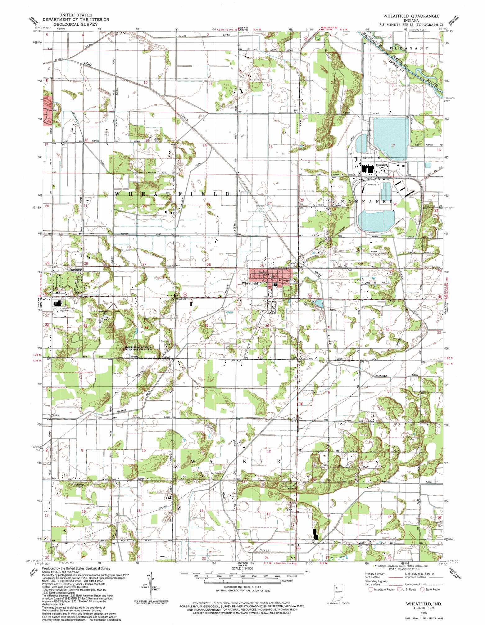
Wheatfield Topo Map Indiana
To zoom in, hover over the map of Wheatfield
USGS Topo Quad 41087b1 - 1:24,000 scale
| Topo Map Name: | Wheatfield |
| USGS Topo Quad ID: | 41087b1 |
| Print Size: | ca. 21 1/4" wide x 27" high |
| Southeast Coordinates: | 41.125° N latitude / 87° W longitude |
| Map Center Coordinates: | 41.1875° N latitude / 87.0625° W longitude |
| U.S. State: | IN |
| Filename: | o41087b1.jpg |
| Download Map JPG Image: | Wheatfield topo map 1:24,000 scale |
| Map Type: | Topographic |
| Topo Series: | 7.5´ |
| Map Scale: | 1:24,000 |
| Source of Map Images: | United States Geological Survey (USGS) |
| Alternate Map Versions: |
Wheatfield IN 1957, updated 1959 Download PDF Buy paper map Wheatfield IN 1957, updated 1980 Download PDF Buy paper map Wheatfield IN 1992, updated 1992 Download PDF Buy paper map Wheatfield IN 2010 Download PDF Buy paper map Wheatfield IN 2013 Download PDF Buy paper map Wheatfield IN 2016 Download PDF Buy paper map |
1:24,000 Topo Quads surrounding Wheatfield
Crown Point |
Palmer |
Valparaiso |
Wanatah |
Hanna |
Leroy |
Hebron |
Kouts |
La Crosse |
English Lake |
Shelby |
Demotte |
Wheatfield |
San Pierre |
North Judson |
Fair Oaks |
Parr |
Gifford |
Medaryville |
North Judson Se |
Mount Ayr |
Rensselaer |
Mccoysburg |
Francesville |
Monon Ne |
> Back to 41087a1 at 1:100,000 scale
> Back to 41086a1 at 1:250,000 scale
> Back to U.S. Topo Maps home
Wheatfield topo map: Gazetteer
Wheatfield: Canals
Davis Ditch elevation 202m 662′Fisher Ditch elevation 204m 669′
Heilsher Ditch elevation 207m 679′
Hickam Lateral elevation 202m 662′
James Ditch elevation 200m 656′
Marble Ditch elevation 200m 656′
Myers Ditch elevation 200m 656′
Schlatzley Ditch elevation 200m 656′
Schrader Ditch elevation 207m 679′
Wheatfield: Populated Places
Stoutsburg elevation 206m 675′Wheatfield elevation 202m 662′
Wheatfield: Streams
Delehanty Ditch elevation 199m 652′Wheatfield digital topo map on disk
Buy this Wheatfield topo map showing relief, roads, GPS coordinates and other geographical features, as a high-resolution digital map file on DVD:
Northern Illinois, Northern Indiana & Southwestern Michigan
Buy digital topo maps: Northern Illinois, Northern Indiana & Southwestern Michigan