Illiana Heights Topo Map Illinois
To zoom in, hover over the map of Illiana Heights
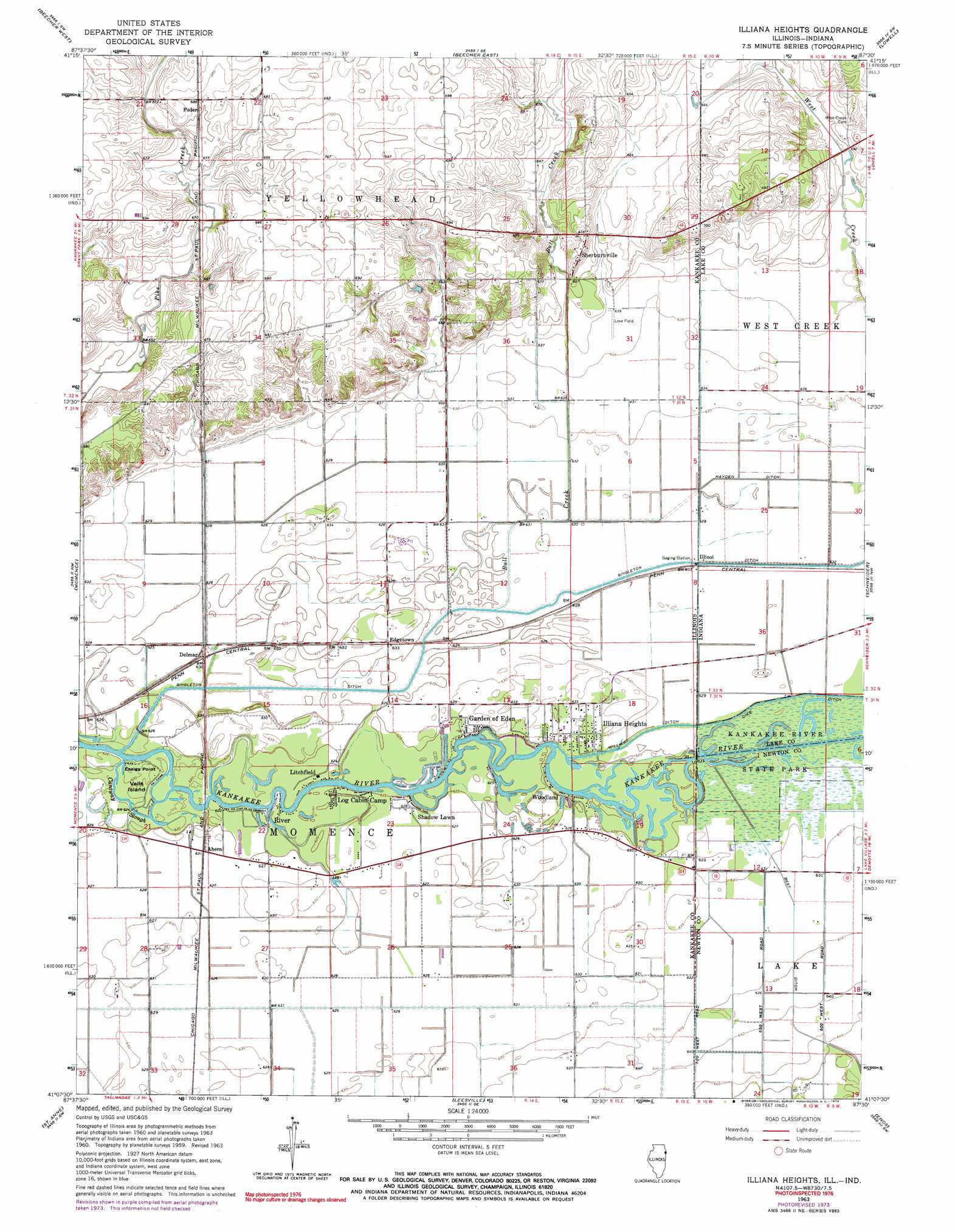
USGS Topo Quad 41087b5 - 1:24,000 scale
| Topo Map Name: | Illiana Heights |
| USGS Topo Quad ID: | 41087b5 |
| Print Size: | ca. 21 1/4" wide x 27" high |
| Southeast Coordinates: | 41.125° N latitude / 87.5° W longitude |
| Map Center Coordinates: | 41.1875° N latitude / 87.5625° W longitude |
| U.S. States: | IL, IN |
| Filename: | o41087b5.jpg |
| Download Map JPG Image: | Illiana Heights topo map 1:24,000 scale |
| Map Type: | Topographic |
| Topo Series: | 7.5´ |
| Map Scale: | 1:24,000 |
| Source of Map Images: | United States Geological Survey (USGS) |
| Alternate Map Versions: |
Momence NE IL 1959, updated 1960 Download PDF Buy paper map Illiana Heights IL 1963, updated 1965 Download PDF Buy paper map Illiana Heights IL 1963, updated 1974 Download PDF Buy paper map Illiana Heights IL 1963, updated 1974 Download PDF Buy paper map Illiana Heights IL 2010 Download PDF Buy paper map Illiana Heights IL 2012 Download PDF Buy paper map Illiana Heights IL 2015 Download PDF Buy paper map |
1:24,000 Topo Quads surrounding Illiana Heights
Frankfort |
Steger |
Dyer |
Saint John |
Crown Point |
Peotone |
Beecher West |
Beecher East |
Lowell |
Leroy |
Bradley |
Momence |
Illiana Heights |
Schneider |
Shelby |
Kankakee |
Saint Anne |
Leesville |
Enos |
Fair Oaks |
L'Erable |
Beaverville |
Donovan |
Morocco |
Mount Ayr |
> Back to 41087a1 at 1:100,000 scale
> Back to 41086a1 at 1:250,000 scale
> Back to U.S. Topo Maps home
Illiana Heights topo map: Gazetteer
Illiana Heights: Airports
Johnson Airport elevation 191m 626′Love Field elevation 194m 636′
Lowell Airport elevation 204m 669′
Illiana Heights: Canals
Carlson Ditch elevation 192m 629′Hayden Ditch elevation 191m 626′
Williams Ditch elevation 192m 629′
Illiana Heights: Capes
Essigs Point elevation 189m 620′Illiana Heights: Guts
Cantway Slough elevation 189m 620′Illiana Heights: Islands
Vails Island elevation 189m 620′Illiana Heights: Parks
Kankakee River State Park elevation 192m 629′Momence Wetlands Nature Preserve elevation 189m 620′
Illiana Heights: Populated Places
Ahern elevation 192m 629′Edgetown elevation 192m 629′
Garden of Eden elevation 193m 633′
Illiana Heights elevation 192m 629′
Illinoi elevation 191m 626′
Lake elevation 193m 633′
Litchfield elevation 189m 620′
Log Cabin Camp elevation 190m 623′
Puder elevation 209m 685′
River elevation 189m 620′
Shadow Lawn elevation 191m 626′
Sherburnville elevation 206m 675′
Woodland elevation 190m 623′
Illiana Heights: Streams
Bull Creek elevation 191m 626′Illiana Heights digital topo map on disk
Buy this Illiana Heights topo map showing relief, roads, GPS coordinates and other geographical features, as a high-resolution digital map file on DVD:
Northern Illinois, Northern Indiana & Southwestern Michigan
Buy digital topo maps: Northern Illinois, Northern Indiana & Southwestern Michigan