Lowell Topo Map Indiana
To zoom in, hover over the map of Lowell
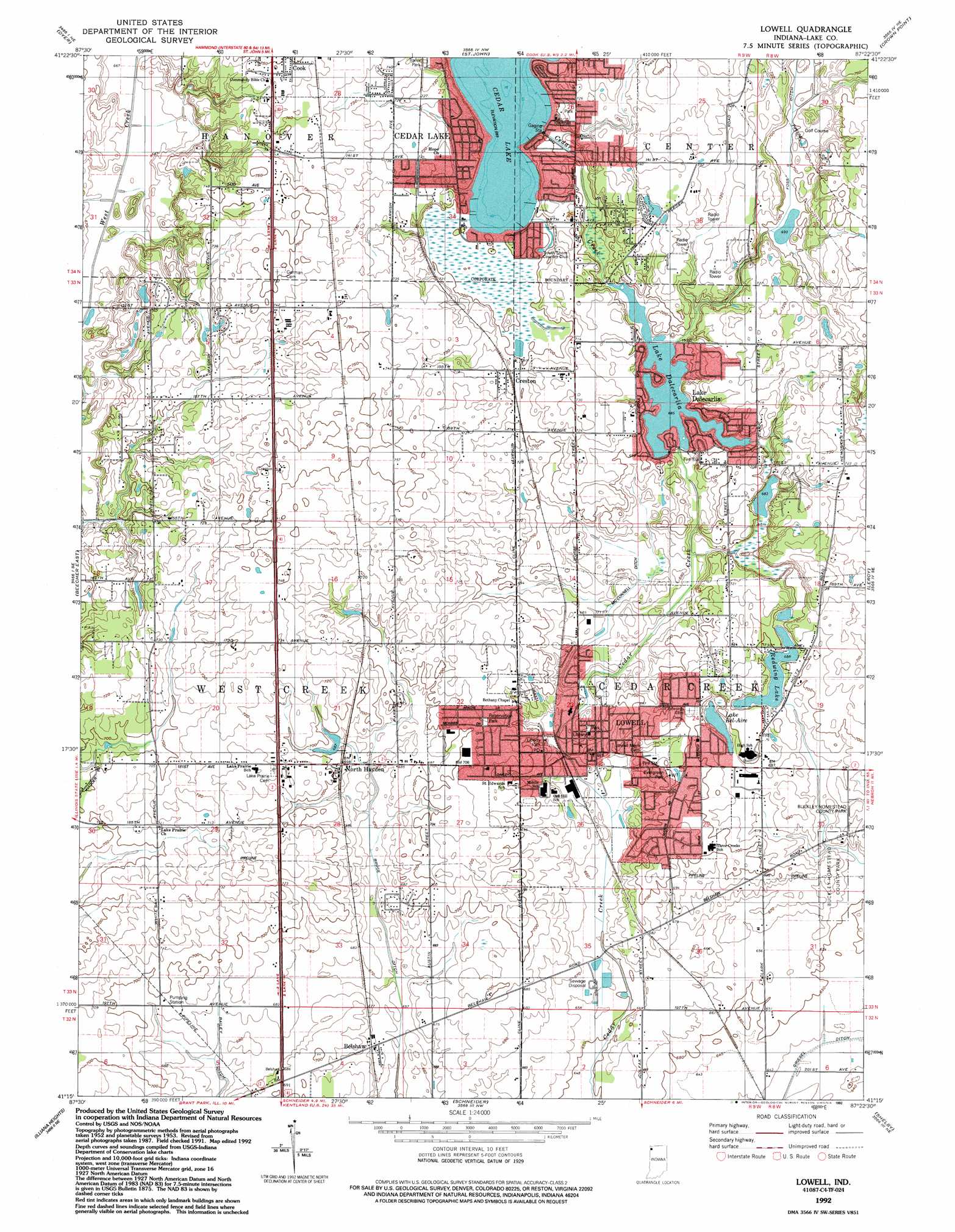
USGS Topo Quad 41087c4 - 1:24,000 scale
| Topo Map Name: | Lowell |
| USGS Topo Quad ID: | 41087c4 |
| Print Size: | ca. 21 1/4" wide x 27" high |
| Southeast Coordinates: | 41.25° N latitude / 87.375° W longitude |
| Map Center Coordinates: | 41.3125° N latitude / 87.4375° W longitude |
| U.S. State: | IN |
| Filename: | o41087c4.jpg |
| Download Map JPG Image: | Lowell topo map 1:24,000 scale |
| Map Type: | Topographic |
| Topo Series: | 7.5´ |
| Map Scale: | 1:24,000 |
| Source of Map Images: | United States Geological Survey (USGS) |
| Alternate Map Versions: |
Lowell IN 1953, updated 1955 Download PDF Buy paper map Lowell IN 1962, updated 1964 Download PDF Buy paper map Lowell IN 1962, updated 1980 Download PDF Buy paper map Lowell IN 1992, updated 1992 Download PDF Buy paper map Lowell IN 2010 Download PDF Buy paper map Lowell IN 2013 Download PDF Buy paper map Lowell IN 2016 Download PDF Buy paper map |
1:24,000 Topo Quads surrounding Lowell
Harvey |
Calumet City |
Highland |
Gary |
Portage |
Steger |
Dyer |
Saint John |
Crown Point |
Palmer |
Beecher West |
Beecher East |
Lowell |
Leroy |
Hebron |
Momence |
Illiana Heights |
Schneider |
Shelby |
Demotte |
Saint Anne |
Leesville |
Enos |
Fair Oaks |
Parr |
> Back to 41087a1 at 1:100,000 scale
> Back to 41086a1 at 1:250,000 scale
> Back to U.S. Topo Maps home
Lowell topo map: Gazetteer
Lowell: Airports
Wistbrook Airport (historical) elevation 207m 679′Lowell: Canals
Bruce Ditch elevation 199m 652′Foss Ditch elevation 212m 695′
McConnel Ditch elevation 203m 666′
Lowell: Dams
Lake Dalecarlia Dam East elevation 206m 675′Lake Dalecarlia Dam West elevation 207m 679′
Lowell: Lakes
Cedar Lake elevation 212m 695′Lake Bel-Aire elevation 206m 675′
Redwing Lake elevation 209m 685′
Lowell: Parks
Buckley Homestead County Park elevation 208m 682′Evergreen Park elevation 213m 698′
Liberty Park elevation 204m 669′
Lowell Commercial Historic District elevation 203m 666′
Onehundredthirtyseventh Avenue Park elevation 218m 715′
Reservation Park elevation 216m 708′
Lowell: Populated Places
Belshaw elevation 206m 675′Cedar Lake elevation 216m 708′
Creston elevation 215m 705′
Lake Dalecarlia elevation 217m 711′
Lowell elevation 204m 669′
North Hayden elevation 214m 702′
Lowell: Post Offices
Lowell Post Office elevation 211m 692′Lowell: Reservoirs
Lake Dalecarlia elevation 206m 675′Lowell digital topo map on disk
Buy this Lowell topo map showing relief, roads, GPS coordinates and other geographical features, as a high-resolution digital map file on DVD:
Northern Illinois, Northern Indiana & Southwestern Michigan
Buy digital topo maps: Northern Illinois, Northern Indiana & Southwestern Michigan