Portage Topo Map Indiana
To zoom in, hover over the map of Portage
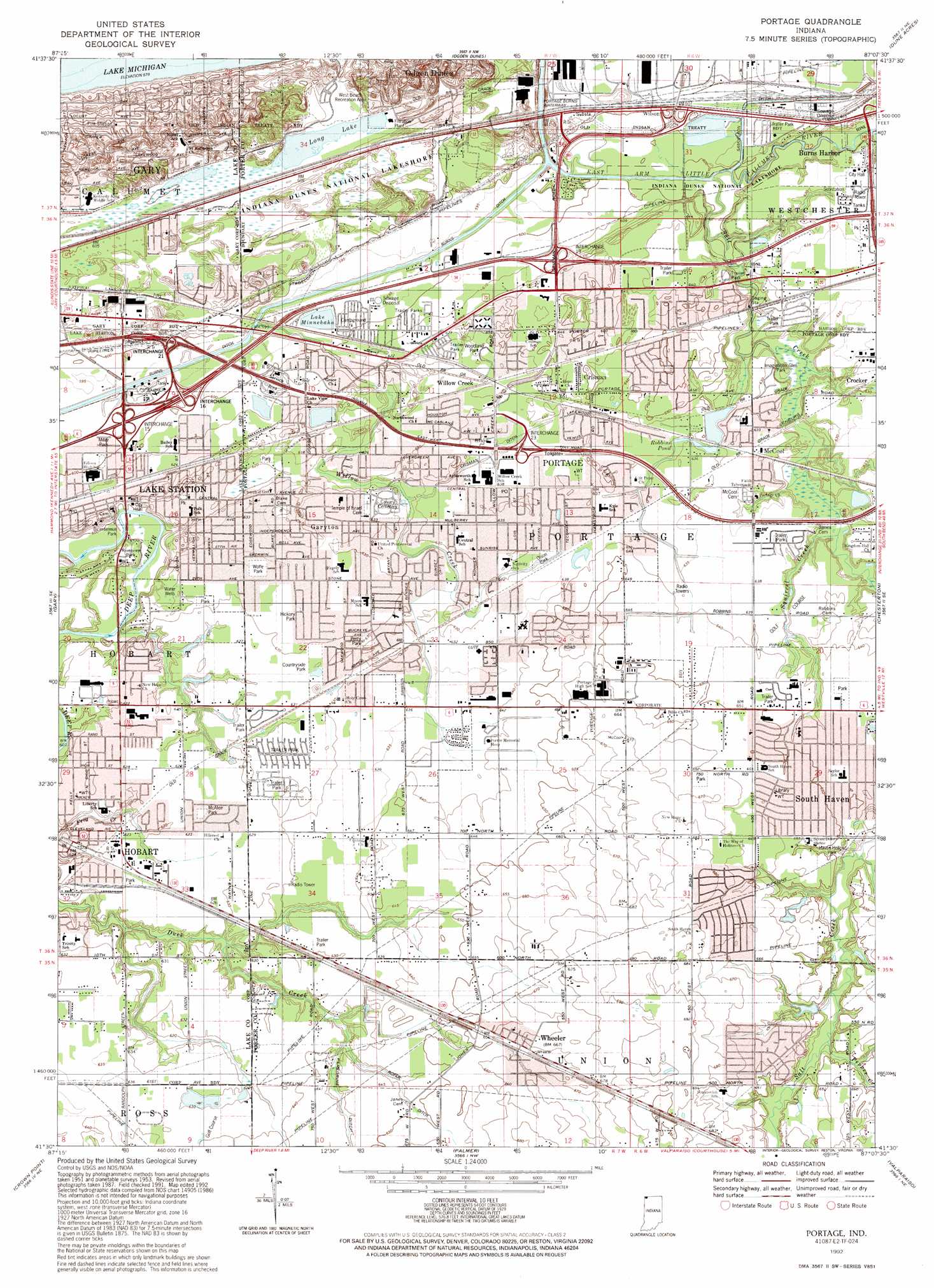
USGS Topo Quad 41087e2 - 1:24,000 scale
| Topo Map Name: | Portage |
| USGS Topo Quad ID: | 41087e2 |
| Print Size: | ca. 21 1/4" wide x 27" high |
| Southeast Coordinates: | 41.5° N latitude / 87.125° W longitude |
| Map Center Coordinates: | 41.5625° N latitude / 87.1875° W longitude |
| U.S. State: | IN |
| Filename: | o41087e2.jpg |
| Download Map JPG Image: | Portage topo map 1:24,000 scale |
| Map Type: | Topographic |
| Topo Series: | 7.5´ |
| Map Scale: | 1:24,000 |
| Source of Map Images: | United States Geological Survey (USGS) |
| Alternate Map Versions: |
Portage IN 1960, updated 1961 Download PDF Buy paper map Portage IN 1960, updated 1967 Download PDF Buy paper map Portage IN 1968, updated 1970 Download PDF Buy paper map Portage IN 1968, updated 1979 Download PDF Buy paper map Portage IN 1968, updated 1981 Download PDF Buy paper map Portage IN 1968, updated 1987 Download PDF Buy paper map Portage IN 1992, updated 1992 Download PDF Buy paper map Portage IN 2010 Download PDF Buy paper map Portage IN 2013 Download PDF Buy paper map Portage IN 2016 Download PDF Buy paper map |
1:24,000 Topo Quads surrounding Portage
Whiting |
Ogden Dunes |
Dune Acres |
Michigan City West |
|
Highland |
Gary |
Portage |
Chesterton |
Westville |
Saint John |
Crown Point |
Palmer |
Valparaiso |
Wanatah |
Lowell |
Leroy |
Hebron |
Kouts |
La Crosse |
> Back to 41087e1 at 1:100,000 scale
> Back to 41086a1 at 1:250,000 scale
> Back to U.S. Topo Maps home
Portage topo map: Gazetteer
Portage: Airports
Carlson Farm Airport (historical) elevation 209m 685′Portage: Canals
Peregrine Ditch elevation 191m 626′Portage-Burns Waterway elevation 182m 597′
Portage: Crossings
Interchange 16 elevation 184m 603′Interchange 19 elevation 191m 626′
Interchange 21 elevation 183m 600′
Interchange 4 elevation 183m 600′
Portage: Lakes
Lake Minnehaha elevation 181m 593′Long Lake elevation 184m 603′
Robbins Pond elevation 192m 629′
Portage: Parks
Bicentennial Park elevation 189m 620′Burns Ditch Rest Park (historical) elevation 183m 600′
Countryside Park elevation 192m 629′
Harbor Oaks Park elevation 188m 616′
Haven Hollow Park elevation 194m 636′
Hickory Park elevation 193m 633′
Imagination Glen Park elevation 185m 606′
McAfee Park elevation 189m 620′
Miller Park elevation 182m 597′
Mock Park elevation 191m 626′
Olson Memorial Park elevation 192m 629′
Pennsy Park elevation 190m 623′
Perry Park elevation 192m 629′
Riverview Park elevation 188m 616′
West Beach Recreation Area elevation 184m 603′
Wolfe Park elevation 193m 633′
Woodland Park elevation 193m 633′
Portage: Populated Places
Camelot Manor Estates elevation 190m 623′Crisman elevation 195m 639′
Dons Mobile Home Park elevation 186m 610′
Garyton elevation 195m 639′
Lake Station elevation 189m 620′
Marine Drive Mobile Home Park elevation 184m 603′
McCool elevation 193m 633′
Meadowview Mobile Home Park elevation 196m 643′
Ogden Dunes elevation 186m 610′
Pleasant Valley elevation 193m 633′
Portage elevation 194m 636′
Salt Creek Estates elevation 195m 639′
Shady Side elevation 185m 606′
Shadyside Mobile Home Court elevation 187m 613′
South Haven elevation 199m 652′
Wheeler elevation 203m 666′
Willow Creek elevation 193m 633′
Wilson elevation 183m 600′
Woodland Village elevation 189m 620′
Portage: Post Offices
Lake Station Post Office elevation 187m 613′Portage: Streams
Crisman Ditch elevation 190m 623′East Arm Little Calumet River elevation 178m 583′
Krull Ditch elevation 189m 620′
Pepper Creek elevation 191m 626′
Robbins Ditch elevation 184m 603′
Roper Ditch elevation 192m 629′
Samuelson Ditch elevation 184m 603′
Squirrel Creek elevation 187m 613′
Willow Creek elevation 182m 597′
Portage digital topo map on disk
Buy this Portage topo map showing relief, roads, GPS coordinates and other geographical features, as a high-resolution digital map file on DVD:
Northern Illinois, Northern Indiana & Southwestern Michigan
Buy digital topo maps: Northern Illinois, Northern Indiana & Southwestern Michigan