Tinley Park Topo Map Illinois
To zoom in, hover over the map of Tinley Park
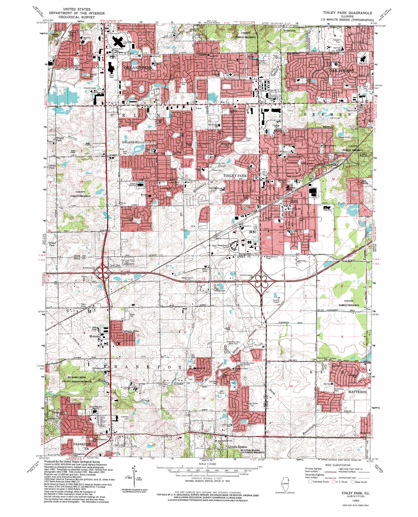
USGS Topo Quad 41087e7 - 1:24,000 scale
| Topo Map Name: | Tinley Park |
| USGS Topo Quad ID: | 41087e7 |
| Print Size: | ca. 21 1/4" wide x 27" high |
| Southeast Coordinates: | 41.5° N latitude / 87.75° W longitude |
| Map Center Coordinates: | 41.5625° N latitude / 87.8125° W longitude |
| U.S. State: | IL |
| Filename: | o41087e7.jpg |
| Download Map JPG Image: | Tinley Park topo map 1:24,000 scale |
| Map Type: | Topographic |
| Topo Series: | 7.5´ |
| Map Scale: | 1:24,000 |
| Source of Map Images: | United States Geological Survey (USGS) |
| Alternate Map Versions: |
Tinley Park IL 1929 Download PDF Buy paper map Tinley Park IL 1929, updated 1941 Download PDF Buy paper map Tinley Park IL 1953, updated 1955 Download PDF Buy paper map Tinley Park IL 1963, updated 1964 Download PDF Buy paper map Tinley Park IL 1963, updated 1974 Download PDF Buy paper map Tinley Park IL 1963, updated 1981 Download PDF Buy paper map Tinley Park IL 1963, updated 1990 Download PDF Buy paper map Tinley Park IL 1993, updated 1993 Download PDF Buy paper map Tinley Park IL 2012 Download PDF Buy paper map Tinley Park IL 2015 Download PDF Buy paper map |
1:24,000 Topo Quads surrounding Tinley Park
Wheaton |
Hinsdale |
Berwyn |
Englewood |
Jackson Park |
Romeoville |
Sag Bridge |
Palos Park |
Blue Island |
Lake Calumet |
Joliet |
Mokena |
Tinley Park |
Harvey |
Calumet City |
Elwood |
Manhattan |
Frankfort |
Steger |
Dyer |
Symerton |
Wilton Center |
Peotone |
Beecher West |
Beecher East |
> Back to 41087e1 at 1:100,000 scale
> Back to 41086a1 at 1:250,000 scale
> Back to U.S. Topo Maps home
Tinley Park topo map: Gazetteer
Tinley Park: Airports
Prosperi Airport (historical) elevation 213m 698′Tinley Park: Canals
Union Ditch elevation 207m 679′Tinley Park: Crossings
Interchange 145 elevation 221m 725′Interchange 148 elevation 220m 721′
Tinley Park: Dams
Midlothian Creek Dam elevation 204m 669′Tinley Park: Parks
Alleymong Park elevation 218m 715′Bannes Park elevation 215m 705′
Bettenhausen Park elevation 211m 692′
Bill Young Park elevation 213m 698′
Bristol Park elevation 213m 698′
Brown Park elevation 212m 695′
Buedingen Park elevation 213m 698′
Cachey Park elevation 213m 698′
Cameno Real Park elevation 216m 708′
Centennial Park elevation 208m 682′
Central Park elevation 200m 656′
Commissioners Park elevation 216m 708′
Convent Park elevation 205m 672′
Corrine Deinert Park elevation 215m 705′
Dogwood Park elevation 208m 682′
El Morro Park elevation 207m 679′
Filson Park elevation 211m 692′
Friendly Oaks Park elevation 202m 662′
German Park elevation 214m 702′
Grove Park elevation 212m 695′
Heght Park elevation 223m 731′
Helen Park elevation 211m 692′
Heritage Park elevation 201m 659′
Hirsch Park elevation 212m 695′
Hoffman Park elevation 212m 695′
Hunter Prairie Park elevation 223m 731′
Hunters Woods County Forest Preserve elevation 221m 725′
Indian Boundary North Park elevation 211m 692′
Indian Boundary South Park elevation 211m 692′
Indian Trail Park elevation 216m 708′
Jesk Park elevation 211m 692′
Kelly Park elevation 214m 702′
Kingston Park elevation 211m 692′
Kiwanis Park elevation 212m 695′
Kiwanis Park elevation 211m 692′
Lagoon Park elevation 202m 662′
Lancaster Woods Park elevation 206m 675′
Liberty Park elevation 210m 688′
Lincoln Meadows Park elevation 222m 728′
McCarthy Park elevation 213m 698′
Memorial Park elevation 212m 695′
Memorial School Park elevation 212m 695′
Orland Tract Forest Preserve elevation 221m 725′
Park Hill Park elevation 210m 688′
Pottawattomie Park elevation 220m 721′
Pulte Park elevation 215m 705′
Rauhoff Park elevation 212m 695′
Richard M Gory Park elevation 215m 705′
Ron Centanni Park elevation 212m 695′
Saint Boniface Park elevation 218m 715′
Sundale Park elevation 212m 695′
Tanglewood Park elevation 213m 698′
Tinley Gardens Tot Lot elevation 225m 738′
Tower Park elevation 204m 669′
Treetop Park elevation 213m 698′
Veterans Park elevation 214m 702′
Veterans Park elevation 217m 711′
Village Square Park elevation 209m 685′
Vogt Woods Park elevation 209m 685′
Volunteer Park elevation 215m 705′
Woodgate Park elevation 213m 698′
Woodlawn Park elevation 219m 718′
Tinley Park: Populated Places
Arbury Hills elevation 220m 721′Fernway elevation 218m 715′
Fernway Park elevation 213m 698′
Frankfort Square elevation 216m 708′
Goeselville elevation 207m 679′
Lincoln Estates elevation 222m 728′
Orland Hills elevation 214m 702′
Tinley Park elevation 213m 698′
Tinley Park: Post Offices
Tinley Park Post Office elevation 214m 702′Tinley Park: Reservoirs
Midlothian Creek Detention Reservoir elevation 204m 669′Tinley Park: Woods
Yankee Woods elevation 208m 682′Tinley Park digital topo map on disk
Buy this Tinley Park topo map showing relief, roads, GPS coordinates and other geographical features, as a high-resolution digital map file on DVD:
Northern Illinois, Northern Indiana & Southwestern Michigan
Buy digital topo maps: Northern Illinois, Northern Indiana & Southwestern Michigan