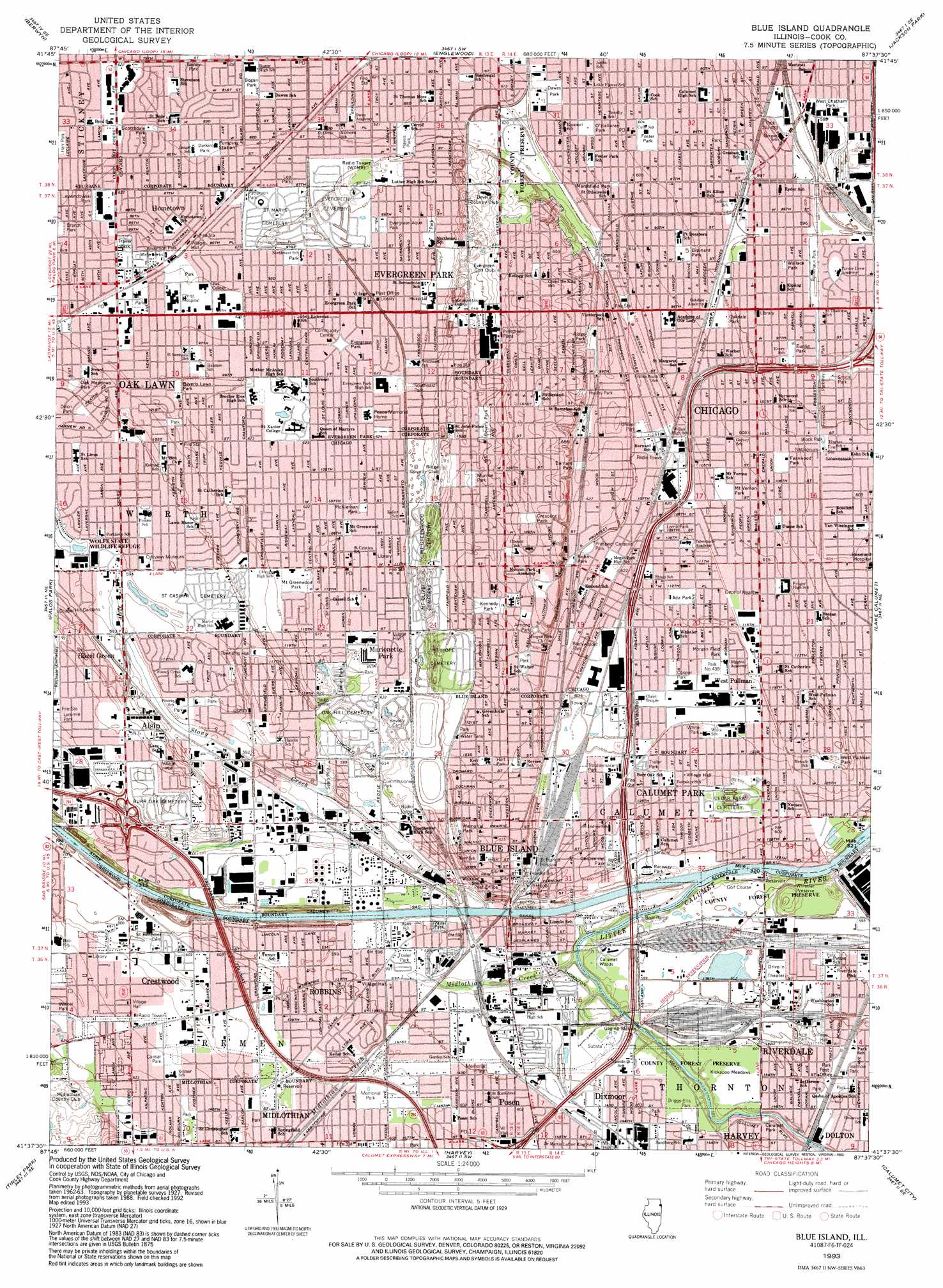
Blue Island Topo Map Illinois
To zoom in, hover over the map of Blue Island
USGS Topo Quad 41087f6 - 1:24,000 scale
| Topo Map Name: | Blue Island |
| USGS Topo Quad ID: | 41087f6 |
| Print Size: | ca. 21 1/4" wide x 27" high |
| Southeast Coordinates: | 41.625° N latitude / 87.625° W longitude |
| Map Center Coordinates: | 41.6875° N latitude / 87.6875° W longitude |
| U.S. State: | IL |
| Filename: | o41087f6.jpg |
| Download Map JPG Image: | Blue Island topo map 1:24,000 scale |
| Map Type: | Topographic |
| Topo Series: | 7.5´ |
| Map Scale: | 1:24,000 |
| Source of Map Images: | United States Geological Survey (USGS) |
| Alternate Map Versions: |
Blue Island IL 1929 Download PDF Buy paper map Blue Island IL 1929, updated 1936 Download PDF Buy paper map Blue Island IL 1929, updated 1948 Download PDF Buy paper map Blue Island IL 1953, updated 1956 Download PDF Buy paper map Blue Island IL 1963, updated 1965 Download PDF Buy paper map Blue Island IL 1963, updated 1974 Download PDF Buy paper map Blue Island IL 1963, updated 1983 Download PDF Buy paper map Blue Island IL 1993, updated 1993 Download PDF Buy paper map Blue Island IL 1993, updated 1993 Download PDF Buy paper map Blue Island IL 1997, updated 1999 Download PDF Buy paper map Blue Island IL 2012 Download PDF Buy paper map Blue Island IL 2015 Download PDF Buy paper map |
1:24,000 Topo Quads surrounding Blue Island
Elmhurst |
River Forest |
Chicago Loop |
||
Hinsdale |
Berwyn |
Englewood |
Jackson Park |
|
Sag Bridge |
Palos Park |
Blue Island |
Lake Calumet |
Whiting |
Mokena |
Tinley Park |
Harvey |
Calumet City |
Highland |
Manhattan |
Frankfort |
Steger |
Dyer |
Saint John |
> Back to 41087e1 at 1:100,000 scale
> Back to 41086a1 at 1:250,000 scale
> Back to U.S. Topo Maps home
Blue Island topo map: Gazetteer
Blue Island: Airports
Alsip Fire Department Heliport elevation 189m 620′Christ Hospital Heliport elevation 189m 620′
Blue Island: Areas
Lanes Island elevation 190m 623′Blue Island: Crossings
Interchange 353 elevation 184m 603′Interchange 354 elevation 184m 603′
Interchange 355 elevation 186m 610′
Interchange 357 elevation 179m 587′
Blue Island: Flats
Kickapoo Meadows elevation 182m 597′Blue Island: Parks
Ada Park elevation 188m 616′Almond Park elevation 199m 652′
Anderson Little League Field elevation 181m 593′
Anderson Park elevation 190m 623′
Apollo Park elevation 190m 623′
Aquatic Park elevation 181m 593′
Barnard Park elevation 192m 629′
Barnes Park elevation 182m 597′
Beverly Lawn Park elevation 189m 620′
Beverly Park elevation 198m 649′
Blackwelder Park elevation 190m 623′
Block Park elevation 183m 600′
Bogan Park elevation 189m 620′
Bohn Park elevation 191m 626′
Brainerd Park elevation 185m 606′
Brandt Park elevation 189m 620′
Bremen Heights Park elevation 190m 623′
Briggs-Ellis Park elevation 182m 597′
Caesar Park elevation 187m 613′
Calumet Park elevation 181m 593′
Centennial Park elevation 184m 603′
Central Park elevation 195m 639′
Central Park elevation 189m 620′
Commissioners Park elevation 182m 597′
Cooper Park elevation 187m 613′
Cosme Park elevation 189m 620′
Crescent Park elevation 201m 659′
Dawes Park elevation 186m 610′
Dillon Park elevation 183m 600′
Durkin Park elevation 189m 620′
Euclid Park elevation 182m 597′
Evergreen Aqua Park elevation 190m 623′
Evergreen Park elevation 190m 623′
Fernwood Park elevation 185m 606′
Fernwood Parkway Park elevation 183m 600′
Ferrell Field elevation 189m 620′
Foster Park elevation 184m 603′
Franson Park elevation 183m 600′
Gaddis Park elevation 189m 620′
Graver Park elevation 190m 623′
Harr Park elevation 189m 620′
Hart Park elevation 195m 639′
Hayes Park elevation 189m 620′
Hurley Park elevation 195m 639′
Ivanhoe Park elevation 184m 603′
Kennedy Park elevation 195m 639′
Ketelaar Tot Lot elevation 181m 593′
Lacrosse Tot Lot elevation 182m 597′
Lamb Park elevation 188m 616′
Laramie Park elevation 189m 620′
Lawn Manor Park elevation 184m 603′
Lee Park elevation 190m 623′
Lewandowski Park elevation 189m 620′
Lindsey Park elevation 184m 603′
Marshfield Park elevation 185m 606′
Mary's Circle elevation 189m 620′
McKiernan Park elevation 190m 623′
Memorial Park elevation 183m 600′
Memorial Park elevation 185m 606′
Mini Park elevation 190m 623′
Morgan Field Park elevation 187m 613′
Mount Greenwood Park elevation 189m 620′
Mount Vernon Park elevation 187m 613′
Munroe Park elevation 196m 643′
Norris Field elevation 191m 626′
Northwest Park elevation 190m 623′
Oak Meadows Park elevation 185m 606′
Oakdale Park elevation 185m 606′
O'Hallaren Park elevation 185m 606′
O'Malley Quadrangle elevation 189m 620′
Park Number 439 elevation 187m 613′
Patterson Park elevation 190m 623′
Prairie Park elevation 183m 600′
Prairie View Park elevation 181m 593′
Progress Park elevation 181m 593′
Prospect Gardens Park elevation 190m 623′
Raceway Park elevation 182m 597′
Ridge Park elevation 193m 633′
Riverdale Park elevation 183m 600′
Robichaux Park elevation 182m 597′
Ronnetree Park elevation 184m 603′
Scottsdale Park elevation 189m 620′
Sears Park elevation 181m 593′
Smith Park elevation 181m 593′
Southeast Park elevation 190m 623′
Troublemakers Park elevation 186m 610′
Walker Park elevation 189m 620′
Wallace Park elevation 183m 600′
West Chatham Park elevation 180m 590′
West Pullman Park elevation 187m 613′
Whistler Preserve elevation 185m 606′
White Park elevation 186m 610′
Wilkins Park elevation 181m 593′
Wolfe Wildlife Refuge elevation 181m 593′
Blue Island: Populated Places
Alsip elevation 190m 623′Andrews and Hurds Subdivision elevation 186m 610′
Ashburn elevation 189m 620′
Beverly elevation 200m 656′
Beverly Hills elevation 199m 652′
Blue Island elevation 195m 639′
Brainerd elevation 185m 606′
Calumet Park elevation 184m 603′
Chester Highlands elevation 183m 600′
Clarkdale elevation 189m 620′
Cookes Subdivision elevation 184m 603′
Dixmoor elevation 183m 600′
Evergreen Park elevation 190m 623′
Gano elevation 188m 616′
Hazel Green elevation 181m 593′
Hometown elevation 190m 623′
Lilydale elevation 182m 597′
Merrionette Park elevation 189m 620′
Midlothian elevation 187m 613′
Mitchells Subdivision elevation 189m 620′
Morgan Park elevation 190m 623′
Mount Greenwood elevation 189m 620′
North Englewood elevation 184m 603′
North Harvey elevation 183m 600′
Placerdale elevation 187m 613′
Posen elevation 183m 600′
Riverdale elevation 183m 600′
Robbins elevation 183m 600′
Roseland elevation 184m 603′
South Englewood elevation 184m 603′
Stewart Ridge elevation 189m 620′
Washington Heights elevation 189m 620′
West Pullman elevation 187m 613′
West Roseland elevation 184m 603′
Blue Island: Post Offices
Blue Island Post Office elevation 193m 633′Evergreen Park Post Office elevation 190m 623′
Morgan Park Station Chicago Post Office elevation 190m 623′
Mount Greenwood Station Chicago Post Office elevation 189m 620′
Posen Post Office elevation 185m 606′
Riverdale Post Office elevation 183m 600′
Robbins Post Office elevation 183m 600′
Blue Island: Reservoirs
Lake Marion elevation 189m 620′Blue Island: Ridges
Blue Island elevation 204m 669′Blue Island Ridge elevation 196m 643′
Blue Island: Streams
Midlothian Creek elevation 178m 583′Blue Island: Woods
Calumet Woods elevation 182m 597′Dan Ryan Woods elevation 189m 620′
Dan Ryan Woods elevation 201m 659′
Blue Island digital topo map on disk
Buy this Blue Island topo map showing relief, roads, GPS coordinates and other geographical features, as a high-resolution digital map file on DVD:
Northern Illinois, Northern Indiana & Southwestern Michigan
Buy digital topo maps: Northern Illinois, Northern Indiana & Southwestern Michigan