Jackson Park Topo Map Illinois
To zoom in, hover over the map of Jackson Park
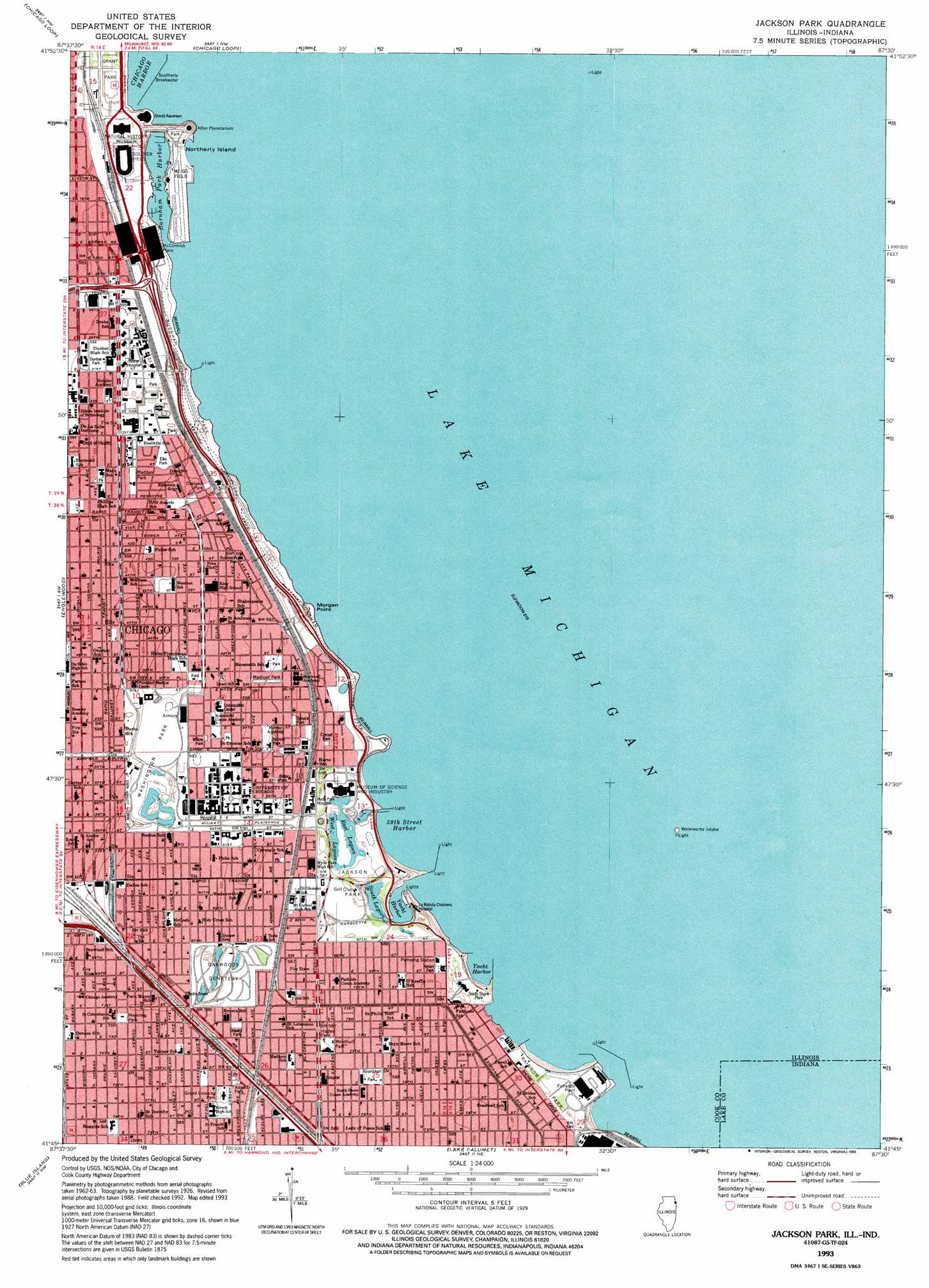
USGS Topo Quad 41087g5 - 1:24,000 scale
| Topo Map Name: | Jackson Park |
| USGS Topo Quad ID: | 41087g5 |
| Print Size: | ca. 21 1/4" wide x 27" high |
| Southeast Coordinates: | 41.75° N latitude / 87.5° W longitude |
| Map Center Coordinates: | 41.8125° N latitude / 87.5625° W longitude |
| U.S. States: | IL, IN |
| Filename: | o41087g5.jpg |
| Download Map JPG Image: | Jackson Park topo map 1:24,000 scale |
| Map Type: | Topographic |
| Topo Series: | 7.5´ |
| Map Scale: | 1:24,000 |
| Source of Map Images: | United States Geological Survey (USGS) |
| Alternate Map Versions: |
Jackson Park IL 1929 Download PDF Buy paper map Jackson Park IL 1929, updated 1939 Download PDF Buy paper map Jackson Park IL 1953, updated 1956 Download PDF Buy paper map Jackson Park IL 1963, updated 1964 Download PDF Buy paper map Jackson Park IL 1963, updated 1973 Download PDF Buy paper map Jackson Park IL 1993, updated 1993 Download PDF Buy paper map Jackson Park IL 1998, updated 1999 Download PDF Buy paper map Jackson Park IL 2012 Download PDF Buy paper map Jackson Park IL 2015 Download PDF Buy paper map |
1:24,000 Topo Quads surrounding Jackson Park
Park Ridge |
Evanston |
|||
River Forest |
Chicago Loop |
|||
Berwyn |
Englewood |
Jackson Park |
||
Palos Park |
Blue Island |
Lake Calumet |
Whiting |
|
Tinley Park |
Harvey |
Calumet City |
Highland |
Gary |
> Back to 41087e1 at 1:100,000 scale
> Back to 41086a1 at 1:250,000 scale
> Back to U.S. Topo Maps home
Jackson Park topo map: Gazetteer
Jackson Park: Airports
Merrill C Meigs Airport (historical) elevation 178m 583′University of Chicago Hospitals Heliport elevation 180m 590′
Jackson Park: Bars
Clarke Point Shoal elevation 175m 574′Clemson Shoal elevation 175m 574′
Hyde Park Shoals elevation 175m 574′
Madison Park Shoal elevation 175m 574′
Morgan Shoal elevation 175m 574′
Oakland Shoal elevation 175m 574′
South Park Shoal elevation 175m 574′
Jackson Park: Bays
Burnham Park Harbor elevation 175m 574′Columbia Basin elevation 175m 574′
Yacht Harbor elevation 175m 574′
Yacht Harbor elevation 175m 574′
Jackson Park: Beaches
Fiftyninth Street Beach elevation 178m 583′Fifty-Seventh Street Beach elevation 176m 577′
Fortyninth Street Beach elevation 178m 583′
Forty-Ninth Street Beach elevation 177m 580′
Jackson Park Beach elevation 177m 580′
Rainbow Park Beach elevation 179m 587′
Sixty-seventh Street Beach elevation 177m 580′
Thirty-first Street Beach elevation 179m 587′
Twelfth Street Beach elevation 175m 574′
Jackson Park: Capes
Clarks Point elevation 179m 587′Morgan Point elevation 176m 577′
Jackson Park: Crossings
Grand Crossing elevation 182m 597′Jackson Park: Dams
Southerly Breakwater elevation 175m 574′Jackson Park: Islands
Northerly Island elevation 179m 587′Wooded Island elevation 178m 583′
Jackson Park: Lakes
East Lagoon elevation 175m 574′South Lagoon elevation 175m 574′
West Lagoon elevation 175m 574′
Jackson Park: Parks
Adams Park elevation 179m 587′Anderson Baseball Diamond elevation 181m 593′
Bixler Park elevation 180m 590′
Burnham Park elevation 175m 574′
Butternut Playlot elevation 180m 590′
Cornell Park elevation 179m 587′
Douglas Monument Park elevation 183m 600′
Drexel Square elevation 181m 593′
Dunbar Park elevation 182m 597′
Ellis Park elevation 183m 600′
George Washington Memorial elevation 183m 600′
Grand Crossing Park elevation 179m 587′
Groveland Park elevation 184m 603′
Haydon Track elevation 181m 593′
Hoard Park elevation 181m 593′
Hodes Park elevation 181m 593′
Jackman Field elevation 180m 590′
Jackson Park elevation 178m 583′
Jeffrey - Cyril Historic District elevation 179m 587′
Jessie 'Ma' Houston Playlot Park elevation 181m 593′
Kenwood Park elevation 180m 590′
Lake Meadows Park elevation 184m 603′
Logan Monument elevation 184m 603′
Madden Park elevation 183m 600′
Madison Park elevation 180m 590′
Meyering Park elevation 179m 587′
Nichols Park elevation 180m 590′
Northerly Island Park elevation 178m 583′
Northerly Island Park elevation 182m 597′
Oakland Park elevation 182m 597′
Perennial Garden elevation 178m 583′
Playlot 291 elevation 180m 590′
Prairie Avenue Historic District elevation 181m 593′
Promontory Point Park elevation 181m 593′
Rainbow Park elevation 180m 590′
Rocky Ledge Park elevation 180m 590′
Rosenblum Park elevation 180m 590′
San Souci Amusement Park (historical) elevation 181m 593′
South Shore Park elevation 180m 590′
Spruce Park elevation 180m 590′
Stagg Field (historical) elevation 180m 590′
Sycamore Playlot elevation 181m 593′
Washington Park elevation 180m 590′
White City Amusement Park elevation 181m 593′
Willow Park elevation 181m 593′
Woodhull Park elevation 181m 593′
Woodland Park elevation 183m 600′
Jackson Park: Populated Places
Aldine Square elevation 183m 600′Berkeley Cottages elevation 182m 597′
Brookdale elevation 181m 593′
Brookline elevation 179m 587′
Burnham Place elevation 181m 593′
Carville elevation 181m 593′
Central Station elevation 181m 593′
Cleaverville elevation 182m 597′
Cornell elevation 182m 597′
Douglas elevation 182m 597′
Egandale elevation 181m 593′
Essex elevation 181m 593′
Film Row elevation 182m 597′
Forestville elevation 183m 600′
Grand Boulevard elevation 183m 600′
Grand Crossing elevation 179m 587′
Grant Village elevation 182m 597′
Harbor Square elevation 181m 593′
Hyde Park elevation 180m 590′
Ida B Wells Housing Project elevation 184m 603′
Italian Bowery elevation 179m 587′
Jackson Park Highlands elevation 180m 590′
Jackson Park Terrace elevation 181m 593′
Kennicott Place elevation 181m 593′
Kenwood elevation 181m 593′
Lake Meadows elevation 183m 600′
McCormick Place elevation 180m 590′
Near South Side elevation 181m 593′
Oakenwald elevation 184m 603′
Oakland elevation 182m 597′
Park Manor elevation 179m 587′
Park Row elevation 181m 593′
Parkside elevation 180m 590′
Poverty Row elevation 179m 587′
Prairie Avenue Courts elevation 181m 593′
Prairie Courts elevation 182m 597′
Prairie Shores elevation 183m 600′
South Commons elevation 181m 593′
South Kenwood elevation 179m 587′
South Shore elevation 180m 590′
Victor A Olander Homes elevation 183m 600′
Washington Park elevation 183m 600′
Washington Park Court elevation 183m 600′
Windsor Park elevation 179m 587′
Woodlawn elevation 180m 590′
Jackson Park digital topo map on disk
Buy this Jackson Park topo map showing relief, roads, GPS coordinates and other geographical features, as a high-resolution digital map file on DVD:
Northern Illinois, Northern Indiana & Southwestern Michigan
Buy digital topo maps: Northern Illinois, Northern Indiana & Southwestern Michigan