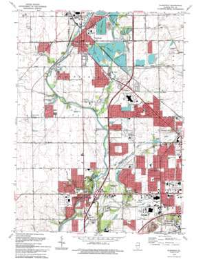
Plainfield Topo Map Illinois
To zoom in, hover over the map of Plainfield
USGS Topo Quad 41088e2 - 1:24,000 scale
| Topo Map Name: | Plainfield |
| USGS Topo Quad ID: | 41088e2 |
| Print Size: | ca. 21 1/4" wide x 27" high |
| Southeast Coordinates: | 41.5° N latitude / 88.125° W longitude |
| Map Center Coordinates: | 41.5625° N latitude / 88.1875° W longitude |
| U.S. State: | IL |
| Filename: | o41088e2.jpg |
| Download Map JPG Image: | Plainfield topo map 1:24,000 scale |
| Map Type: | Topographic |
| Topo Series: | 7.5´ |
| Map Scale: | 1:24,000 |
| Source of Map Images: | United States Geological Survey (USGS) |
| Alternate Map Versions: |
Plainfield IL 1954, updated 1955 Download PDF Buy paper map Plainfield IL 1962, updated 1963 Download PDF Buy paper map Plainfield IL 1962, updated 1974 Download PDF Buy paper map Plainfield IL 1962, updated 1981 Download PDF Buy paper map Plainfield IL 1993, updated 1994 Download PDF Buy paper map Plainfield IL 1998, updated 2002 Download PDF Buy paper map Plainfield IL 2012 Download PDF Buy paper map Plainfield IL 2015 Download PDF Buy paper map |
1:24,000 Topo Quads surrounding Plainfield
> Back to 41088e1 at 1:100,000 scale
> Back to 41088a1 at 1:250,000 scale
> Back to U.S. Topo Maps home
Plainfield topo map: Gazetteer
Plainfield: Airports
Joliet Park District Airport elevation 177m 580′Saint Joseph Medical Center Heliport elevation 195m 639′
Plainfield: Crossings
Interchange 130 elevation 190m 623′Interchange 251 elevation 182m 597′
Interchange 253 elevation 178m 583′
Interchange 257 elevation 192m 629′
Plainfield: Dams
Joliet Junior College Lake Dam elevation 173m 567′Puddle Pond Dam elevation 183m 600′
Plainfield: Lakes
Lake Plainfield elevation 185m 606′Lake Renwick elevation 180m 590′
Legion Lake elevation 183m 600′
Plainfield: Parks
Ca Crest Park elevation 185m 606′College Park elevation 182m 597′
Country West Park elevation 186m 610′
Four Seasons Park elevation 186m 610′
Hammel Woods County Forest Preserve elevation 174m 570′
Inwood Park elevation 184m 603′
Joliet Municipal Stadium elevation 189m 620′
Lake Renwick County Forest Preserve elevation 180m 590′
Lake Renwick Heron Rookery Nature Preserve elevation 180m 590′
Middle Rock Run County Forest Preserve elevation 173m 567′
Ottawa Park elevation 189m 620′
Renwick Community Park Complex elevation 185m 606′
Rock Run County Forest Preserve elevation 177m 580′
Shorewood Park elevation 178m 583′
Theodore Marsh County Forest Preserve elevation 178m 583′
Village Green Park elevation 186m 610′
West Shore Park elevation 175m 574′
Plainfield: Populated Places
Arbor Creek elevation 187m 613′Arbor Settlement elevation 183m 600′
Aspen Meadows elevation 188m 616′
Autumn Lake Estates elevation 180m 590′
Brighton Lakes elevation 189m 620′
Brookside elevation 189m 620′
Canton Crossing elevation 183m 600′
Caton Farm elevation 189m 620′
County Glen elevation 183m 600′
Coynes elevation 190m 623′
Crest Estates elevation 187m 613′
Crystal Lawns elevation 184m 603′
Deer Run Estates elevation 176m 577′
Erin elevation 183m 600′
Essex elevation 182m 597′
Fairway Estates elevation 186m 610′
Fond du Lac elevation 187m 613′
Fox Meadow elevation 179m 587′
Grand Haven elevation 193m 633′
Grand Prairie elevation 189m 620′
Heritage Lake Estates elevation 188m 616′
Heron View Estates elevation 184m 603′
Hunt Club elevation 189m 620′
Larkins Pointe elevation 198m 649′
Liberty Grove elevation 190m 623′
Lily Cache elevation 183m 600′
McKenna Woods elevation 186m 610′
Mirage elevation 192m 629′
Northfield elevation 190m 623′
Oakwood Estates elevation 181m 593′
Old Kent elevation 189m 620′
Old Oaks elevation 179m 587′
Park Place elevation 183m 600′
Pheasant Landing elevation 184m 603′
Picardy elevation 185m 606′
Plainsman Terrace elevation 181m 593′
Pleasant Knoll elevation 188m 616′
Prairie Trail elevation 188m 616′
River Glen elevation 180m 590′
River Oaks West elevation 181m 593′
Riverbrook Estates elevation 189m 620′
Riverside at Ole Canton Farm elevation 181m 593′
Riverwalk elevation 181m 593′
Sayles Manor elevation 193m 633′
Shorewood elevation 176m 577′
Shorewood Beach elevation 175m 574′
Shorewood Park elevation 175m 574′
Spangler Farms elevation 185m 606′
Springwood elevation 176m 577′
Springwood South elevation 180m 590′
Squires Mill elevation 180m 590′
Stonegate elevation 197m 646′
Summerfield elevation 188m 616′
Sunset Hills elevation 180m 590′
Sunset Ridge elevation 181m 593′
Vintage elevation 183m 600′
Vintage Harvest elevation 183m 600′
Walker elevation 187m 613′
Wallin Woods elevation 190m 623′
Wedgewood elevation 187m 613′
Wellington Heights elevation 185m 606′
Wesglen elevation 193m 633′
Wesmere elevation 188m 616′
Westlake elevation 190m 623′
Wexford elevation 181m 593′
Wexford East elevation 179m 587′
Williamsburg elevation 190m 623′
Winding Creek elevation 187m 613′
Plainfield: Post Offices
Plainfield Post Office elevation 186m 610′Plainfield: Reservoirs
Joliet Junior College Lake elevation 173m 567′Puddle Pond elevation 183m 600′
Plainfield: Streams
Lily Cache Creek elevation 178m 583′Mink Creek elevation 180m 590′
Plainfield: Woods
Hammel Woods elevation 185m 606′Plainfield digital topo map on disk
Buy this Plainfield topo map showing relief, roads, GPS coordinates and other geographical features, as a high-resolution digital map file on DVD:
Northern Illinois, Northern Indiana & Southwestern Michigan
Buy digital topo maps: Northern Illinois, Northern Indiana & Southwestern Michigan


