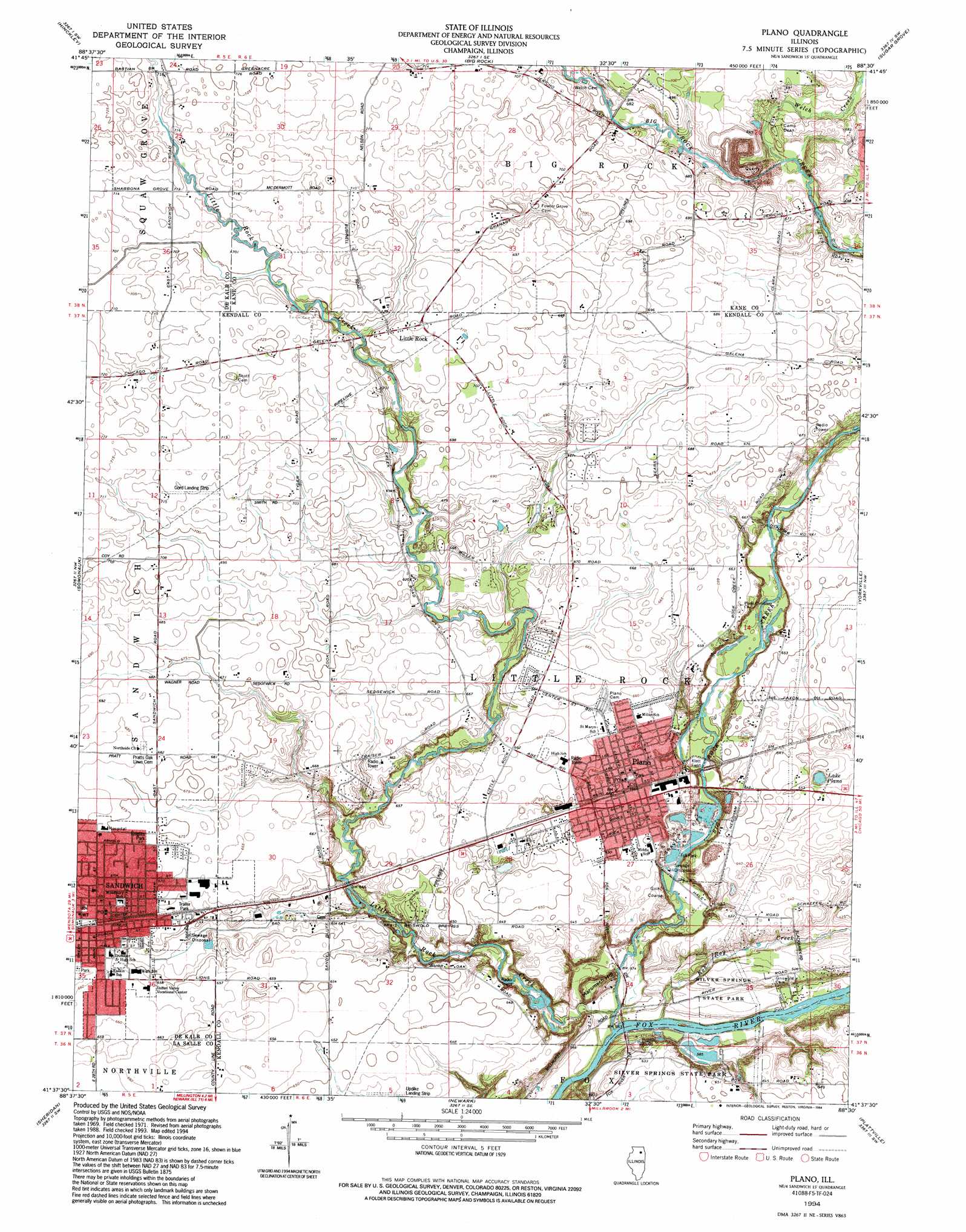
Plano Topo Map Illinois
To zoom in, hover over the map of Plano
USGS Topo Quad 41088f5 - 1:24,000 scale
| Topo Map Name: | Plano |
| USGS Topo Quad ID: | 41088f5 |
| Print Size: | ca. 21 1/4" wide x 27" high |
| Southeast Coordinates: | 41.625° N latitude / 88.5° W longitude |
| Map Center Coordinates: | 41.6875° N latitude / 88.5625° W longitude |
| U.S. State: | IL |
| Filename: | o41088f5.jpg |
| Download Map JPG Image: | Plano topo map 1:24,000 scale |
| Map Type: | Topographic |
| Topo Series: | 7.5´ |
| Map Scale: | 1:24,000 |
| Source of Map Images: | United States Geological Survey (USGS) |
| Alternate Map Versions: |
Plano IL 1971, updated 1973 Download PDF Buy paper map Plano IL 1994, updated 1994 Download PDF Buy paper map Plano IL 2012 Download PDF Buy paper map Plano IL 2015 Download PDF Buy paper map |
1:24,000 Topo Quads surrounding Plano
De Kalb |
Sycamore |
Maple Park |
Elburn |
Geneva |
Waterman |
Hinckley |
Big Rock |
Sugar Grove |
Aurora North |
Shabbona Grove |
Somonauk |
Plano |
Yorkville |
Aurora South |
Leland |
Sheridan |
Newark |
Plattville |
Yorkville Se |
Wedron |
Serena |
Stavanger |
Lisbon |
Minooka |
> Back to 41088e1 at 1:100,000 scale
> Back to 41088a1 at 1:250,000 scale
> Back to U.S. Topo Maps home
Plano topo map: Gazetteer
Plano: Airports
Gord Airport elevation 217m 711′Hospital Heliport elevation 204m 669′
Updike Landing Strip elevation 195m 639′
Wiley Updike Airport elevation 196m 643′
Plano: Lakes
Lake Plano elevation 191m 626′Plano: Parks
Foli Park elevation 177m 580′Klatt Field elevation 182m 597′
Knights Park elevation 205m 672′
Maramach Forest Preserve elevation 195m 639′
Maramech Woods Nature Preserve elevation 177m 580′
Silver Springs State Park elevation 199m 652′
Plano: Populated Places
Little Rock elevation 216m 708′Plano elevation 198m 649′
Sandwich elevation 203m 666′
Plano: Post Offices
Plano Post Office elevation 199m 652′Sandwich Post Office elevation 201m 659′
Plano: Reservoirs
Beaver Lake elevation 176m 577′Loon Lake elevation 179m 587′
Plano: Streams
Big Rock Creek elevation 170m 557′Little Rock Creek elevation 170m 557′
Rob Roy Creek elevation 170m 557′
Welch Creek elevation 199m 652′
Welch Creek elevation 199m 652′
Plano: Summits
Maramech Hill elevation 196m 643′Plano: Trails
Beaver Dam Hiking and Cross-Country Ski Trail elevation 186m 610′Fox Ridge Nature Trail elevation 184m 603′
Prairie View Equestrian Trail elevation 193m 633′
Plano digital topo map on disk
Buy this Plano topo map showing relief, roads, GPS coordinates and other geographical features, as a high-resolution digital map file on DVD:
Northern Illinois, Northern Indiana & Southwestern Michigan
Buy digital topo maps: Northern Illinois, Northern Indiana & Southwestern Michigan