Aurora North Topo Map Illinois
To zoom in, hover over the map of Aurora North
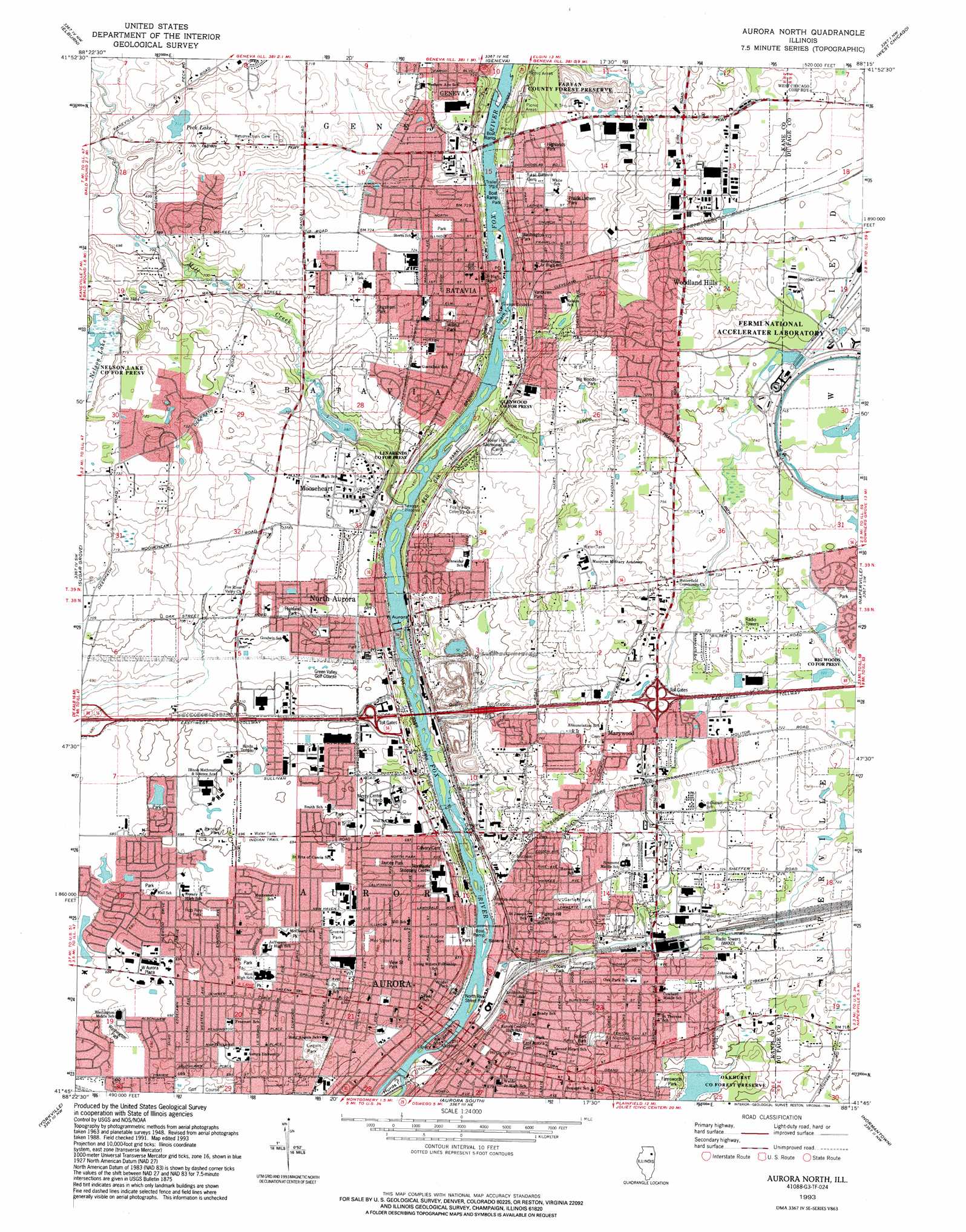
USGS Topo Quad 41088g3 - 1:24,000 scale
| Topo Map Name: | Aurora North |
| USGS Topo Quad ID: | 41088g3 |
| Print Size: | ca. 21 1/4" wide x 27" high |
| Southeast Coordinates: | 41.75° N latitude / 88.25° W longitude |
| Map Center Coordinates: | 41.8125° N latitude / 88.3125° W longitude |
| U.S. State: | IL |
| Filename: | o41088g3.jpg |
| Download Map JPG Image: | Aurora North topo map 1:24,000 scale |
| Map Type: | Topographic |
| Topo Series: | 7.5´ |
| Map Scale: | 1:24,000 |
| Source of Map Images: | United States Geological Survey (USGS) |
| Alternate Map Versions: |
Aurora North IL 1950 Download PDF Buy paper map Aurora North IL 1964, updated 1965 Download PDF Buy paper map Aurora North IL 1964, updated 1973 Download PDF Buy paper map Aurora North IL 1964, updated 1983 Download PDF Buy paper map Aurora North IL 1993, updated 1994 Download PDF Buy paper map Aurora North IL 1998, updated 2002 Download PDF Buy paper map Aurora North IL 2012 Download PDF Buy paper map Aurora North IL 2015 Download PDF Buy paper map |
1:24,000 Topo Quads surrounding Aurora North
Hampshire |
Pingree Grove |
Elgin |
Streamwood |
Palatine |
Maple Park |
Elburn |
Geneva |
West Chicago |
Lombard |
Big Rock |
Sugar Grove |
Aurora North |
Naperville |
Wheaton |
Plano |
Yorkville |
Aurora South |
Normantown |
Romeoville |
Newark |
Plattville |
Yorkville Se |
Plainfield |
Joliet |
> Back to 41088e1 at 1:100,000 scale
> Back to 41088a1 at 1:250,000 scale
> Back to U.S. Topo Maps home
Aurora North topo map: Gazetteer
Aurora North: Airports
Mercy Center for Health Care Services Heliport elevation 213m 698′Aurora North: Dams
Aurora Dam elevation 196m 643′Batavia Dam elevation 217m 711′
Mooseheart Lake Dam elevation 208m 682′
North Aurora Dam elevation 205m 672′
Aurora North: Forests
Fabyan County Forest Preserve elevation 241m 790′Aurora North: Islands
Clark Island elevation 199m 652′Hurds Island elevation 198m 649′
North Aurora Island elevation 197m 646′
Spiers Island elevation 191m 626′
Stolp Island elevation 191m 626′
Aurora North: Lakes
Peck Lake elevation 217m 711′Aurora North: Parks
Beach Park elevation 202m 662′Big Woods Park elevation 237m 777′
Braeburn Marsh County Forest Preserve elevation 215m 705′
Copley Park elevation 212m 695′
Dick Young County Forest Preserve elevation 217m 711′
Engstrom Park elevation 222m 728′
Exposition Park (historical) elevation 215m 705′
Farnsworth Park elevation 216m 708′
Foxcroft Park elevation 210m 688′
Garfield Park elevation 220m 721′
Glenwood County Forest Preserve elevation 203m 666′
Goodwin Park elevation 210m 688′
Greene Park elevation 209m 685′
Gregory Park elevation 189m 620′
Hall Park elevation 210m 688′
Highland Park elevation 214m 702′
Highlands Park elevation 219m 718′
Illinois Avenue Island Park elevation 191m 626′
Illinois Avenue Park elevation 194m 636′
Jaycee Park elevation 211m 692′
Jefferson Park elevation 210m 688′
Les Arends County Forest Preserve elevation 203m 666′
Lincoln Park elevation 203m 666′
May Street Park elevation 207m 679′
McCarty Park elevation 207m 679′
McCleery Park elevation 207m 679′
McCullough Park elevation 203m 666′
Memorial Field elevation 221m 725′
Nelson Lake County Forest Preserve elevation 220m 721′
North Aurora Island Park elevation 197m 646′
North River Street Park elevation 194m 636′
Oakhurst County Forest Preserve elevation 214m 702′
O'Donnell Park elevation 219m 718′
Pigeon Hill Park elevation 216m 708′
Prairie Lathem Park elevation 220m 721′
Prairie Path Woodland Swamp County Forest Preserve elevation 219m 718′
Quarry Park elevation 202m 662′
Randall Park elevation 213m 698′
Red Oak Park elevation 205m 672′
Rob Roy Park elevation 211m 692′
Rollins Park elevation 217m 711′
Schneider Park elevation 219m 718′
Simmons Park elevation 221m 725′
Snell Baseball Field elevation 210m 688′
Stevens Playground elevation 208m 682′
Vanburen Park elevation 217m 711′
View Street Park elevation 208m 682′
Walnut Park elevation 220m 721′
Washington Park elevation 207m 679′
Washington Park elevation 216m 708′
Wilder Park elevation 204m 669′
Aurora North: Populated Places
Aurora elevation 207m 679′Batavia elevation 218m 715′
Exposition View elevation 211m 692′
Heaton Park elevation 222m 728′
Heritage West elevation 223m 731′
Marywood elevation 225m 738′
Mooseheart elevation 220m 721′
North Aurora elevation 207m 679′
Randall Hills elevation 219m 718′
Spring Green elevation 218m 715′
Tanglewood elevation 226m 741′
Wenmoth Acres elevation 216m 708′
Woodland Hills elevation 231m 757′
Aurora North: Post Offices
Batavia Post Office elevation 204m 669′North Aurora Post Office elevation 206m 675′
Aurora North: Reservoirs
Foxcroft Lake elevation 208m 682′Mooseheart Lake elevation 208m 682′
Aurora North: Streams
Batavia Creek elevation 195m 639′East Run North Branch elevation 207m 679′
Mill Creek elevation 197m 646′
Aurora North: Woods
Big Woods (historical) elevation 234m 767′Aurora North digital topo map on disk
Buy this Aurora North topo map showing relief, roads, GPS coordinates and other geographical features, as a high-resolution digital map file on DVD:
Northern Illinois, Northern Indiana & Southwestern Michigan
Buy digital topo maps: Northern Illinois, Northern Indiana & Southwestern Michigan