Geneva Topo Map Illinois
To zoom in, hover over the map of Geneva
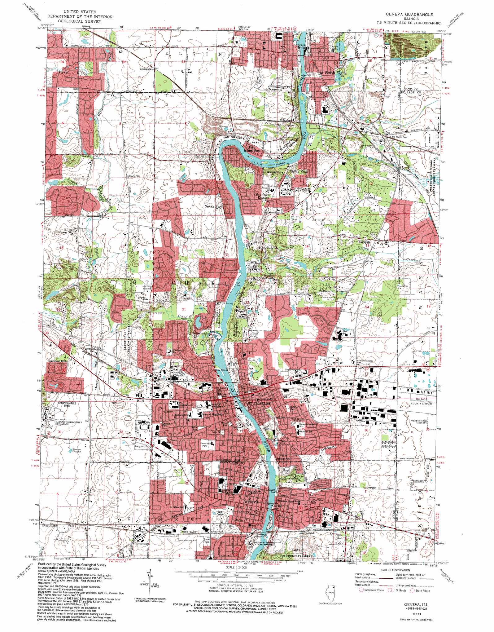
USGS Topo Quad 41088h3 - 1:24,000 scale
| Topo Map Name: | Geneva |
| USGS Topo Quad ID: | 41088h3 |
| Print Size: | ca. 21 1/4" wide x 27" high |
| Southeast Coordinates: | 41.875° N latitude / 88.25° W longitude |
| Map Center Coordinates: | 41.9375° N latitude / 88.3125° W longitude |
| U.S. State: | IL |
| Filename: | o41088h3.jpg |
| Download Map JPG Image: | Geneva topo map 1:24,000 scale |
| Map Type: | Topographic |
| Topo Series: | 7.5´ |
| Map Scale: | 1:24,000 |
| Source of Map Images: | United States Geological Survey (USGS) |
| Alternate Map Versions: |
Geneva IL 1949 Download PDF Buy paper map Geneva IL 1964, updated 1965 Download PDF Buy paper map Geneva IL 1964, updated 1973 Download PDF Buy paper map Geneva IL 1964, updated 1981 Download PDF Buy paper map Geneva IL 1964, updated 1987 Download PDF Buy paper map Geneva IL 1993, updated 1994 Download PDF Buy paper map Geneva IL 1998, updated 2002 Download PDF Buy paper map Geneva IL 2012 Download PDF Buy paper map Geneva IL 2015 Download PDF Buy paper map |
1:24,000 Topo Quads surrounding Geneva
Marengo South |
Huntley |
Crystal Lake |
Barrington |
Lake Zurich |
Hampshire |
Pingree Grove |
Elgin |
Streamwood |
Palatine |
Maple Park |
Elburn |
Geneva |
West Chicago |
Lombard |
Big Rock |
Sugar Grove |
Aurora North |
Naperville |
Wheaton |
Plano |
Yorkville |
Aurora South |
Normantown |
Romeoville |
> Back to 41088e1 at 1:100,000 scale
> Back to 41088a1 at 1:250,000 scale
> Back to U.S. Topo Maps home
Geneva topo map: Gazetteer
Geneva: Dams
Saint Charles South Dam elevation 211m 692′Geneva: Forests
Pratts Wayne Woods Forest Preserve elevation 228m 748′Geneva: Islands
Boy Scout Island elevation 212m 695′Five Islands elevation 209m 685′
Geneva: Mines
Fox River Quarry elevation 208m 682′Geneva: Parks
Baker Park elevation 225m 738′Bennett Park elevation 210m 688′
Blackhawk County Forest Preserve elevation 212m 695′
Burgess Field elevation 230m 754′
Cambridge Park elevation 232m 761′
Campton Hills Park elevation 234m 767′
Concord Park elevation 237m 777′
Delnor Woods Park elevation 229m 751′
Driessen Park elevation 231m 757′
Dryden Park elevation 225m 738′
Elfstrom Stadium elevation 234m 767′
Elm Park elevation 227m 744′
Fairview Park elevation 239m 784′
Ferson Creek County Forest Preserve elevation 227m 744′
Ferson Creek Fen Nature Preserve elevation 212m 695′
Ferson Creek Park elevation 212m 695′
Fox Chase Park elevation 236m 774′
Fox River Bluff County Forest Preserve elevation 212m 695′
Fox River Bluff West County Forest Preserve elevation 228m 748′
Good Templar Park elevation 219m 718′
Gunnar Anderson County Forest Preserve elevation 215m 705′
Hazletine Park elevation 210m 688′
Hunt Club Park elevation 232m 761′
Island Park elevation 204m 669′
Kane County Fairgrounds elevation 243m 797′
Kehoe Park elevation 236m 774′
Kenyon Farm County Forest Preserve elevation 225m 738′
Langum Park elevation 219m 718′
LeRoy Oakes Nature Preserve elevation 233m 764′
Leroy Oaks County Forest Preserve elevation 233m 764′
Lincoln Park elevation 220m 721′
Lions Park elevation 213m 698′
Mill Creek County Forest Preserve elevation 224m 734′
Moody Park elevation 229m 751′
Mount Saint Mary Park elevation 210m 688′
Norris Woods Nature Preserve elevation 224m 734′
Old Mill Park elevation 209m 685′
Otter Creek County Forest Preserve elevation 240m 787′
Panton Mill Park elevation 213m 698′
Pickeral Park elevation 212m 695′
Pottawatomie Park elevation 214m 702′
Prairie Park elevation 234m 767′
Primrose Farm Park elevation 232m 761′
Riverside Park elevation 210m 688′
Rotary Park elevation 229m 751′
Saint Charles Athletic Field elevation 234m 767′
Seba Park elevation 213m 698′
Severson Forest Preserve elevation 219m 718′
Sunset Park elevation 226m 741′
Surrey Hill Park elevation 235m 770′
Taly Park elevation 212m 695′
Tekakwitha County Forest Preserve elevation 227m 744′
Timbers Park elevation 222m 728′
Vasa Park elevation 221m 725′
West Side Park elevation 226m 741′
Wheeler Park elevation 213m 698′
Wredling Sports Complex elevation 237m 777′
Geneva: Populated Places
Bakers Acres elevation 241m 790′Bonnie Valley elevation 239m 784′
Coleman elevation 228m 748′
Crane Road Estates elevation 231m 757′
Crane Woods Estates elevation 235m 770′
Dunham Castle elevation 237m 777′
Evanswood elevation 241m 790′
Farmington elevation 222m 728′
Ferson Creek Woods elevation 237m 777′
Five Island Park elevation 213m 698′
Fox River Estates elevation 219m 718′
Fox River Heights elevation 233m 764′
Geneva elevation 217m 711′
Hawkins Glen elevation 229m 751′
Knoll Creek West elevation 229m 751′
Lake Charlotte elevation 240m 787′
Longview Estates elevation 246m 807′
Mallard Lake North elevation 242m 793′
Mallard Lake South elevation 241m 790′
Middlecreek elevation 238m 780′
Novak Park elevation 221m 725′
Pheasant Run elevation 247m 810′
Rainbow Hills elevation 255m 836′
Redgate Ridge elevation 244m 800′
River Grange Lakes elevation 243m 797′
Saint Charles elevation 223m 731′
South Elgin elevation 216m 708′
Surrey Woods elevation 235m 770′
Thornley elevation 217m 711′
Valley View elevation 231m 757′
Wayne elevation 228m 748′
Wildrose elevation 238m 780′
Wildrose Valley elevation 216m 708′
Youngsdale elevation 245m 803′
Geneva: Post Offices
Geneva Post Office elevation 220m 721′Saint Charles Post Office elevation 230m 754′
South Elgin Post Office elevation 226m 741′
Geneva: Reservoirs
Saint Charles South Lake elevation 211m 692′Geneva: Streams
Bowes Creek elevation 240m 787′Brewster Creek elevation 212m 695′
Country Club Road Run elevation 218m 715′
Ferson Creek elevation 209m 685′
Great Western Run elevation 220m 721′
Norton Creek elevation 211m 692′
Otter Creek elevation 228m 748′
Stony Creek elevation 234m 767′
Geneva digital topo map on disk
Buy this Geneva topo map showing relief, roads, GPS coordinates and other geographical features, as a high-resolution digital map file on DVD:
Northern Illinois, Northern Indiana & Southwestern Michigan
Buy digital topo maps: Northern Illinois, Northern Indiana & Southwestern Michigan