Florid Topo Map Illinois
To zoom in, hover over the map of Florid
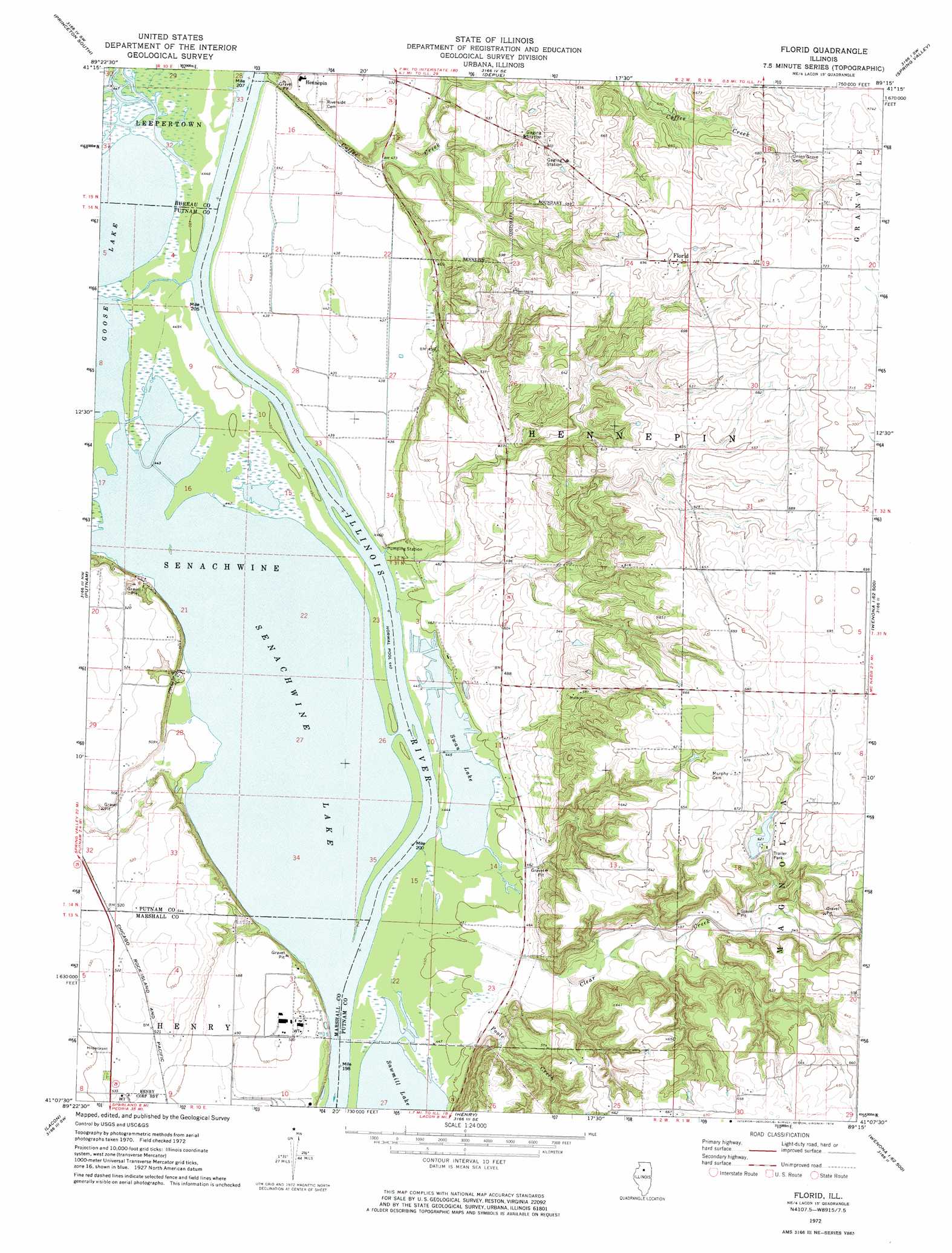
USGS Topo Quad 41089b3 - 1:24,000 scale
| Topo Map Name: | Florid |
| USGS Topo Quad ID: | 41089b3 |
| Print Size: | ca. 21 1/4" wide x 27" high |
| Southeast Coordinates: | 41.125° N latitude / 89.25° W longitude |
| Map Center Coordinates: | 41.1875° N latitude / 89.3125° W longitude |
| U.S. State: | IL |
| Filename: | o41089b3.jpg |
| Download Map JPG Image: | Florid topo map 1:24,000 scale |
| Map Type: | Topographic |
| Topo Series: | 7.5´ |
| Map Scale: | 1:24,000 |
| Source of Map Images: | United States Geological Survey (USGS) |
| Alternate Map Versions: |
Florid IL 1972, updated 1974 Download PDF Buy paper map Florid IL 1972, updated 1974 Download PDF Buy paper map Florid IL 2012 Download PDF Buy paper map Florid IL 2015 Download PDF Buy paper map |
1:24,000 Topo Quads surrounding Florid
Buoane |
Princeton North |
Malden |
Ladd |
Troy Grove |
Wyanet |
Princeton South |
Depue |
Spring Valley |
La Salle |
Whitefield |
Putnam |
Florid |
Mcnabb |
Tonica |
La Prairie Center |
Lacon |
Henry |
Varna |
Wenona |
Rome |
Chillicothe |
Washburn |
La Rose |
Minonk |
> Back to 41089a1 at 1:100,000 scale
> Back to 41088a1 at 1:250,000 scale
> Back to U.S. Topo Maps home
Florid topo map: Gazetteer
Florid: Airports
Little Sister Seaplane Base elevation 136m 446′Florid: Dams
Fish N Fun Lake Dam elevation 189m 620′Florid: Lakes
Senachwine Lake elevation 136m 446′Swan Lake elevation 136m 446′
Florid: Parks
Lake Senachwine Conservation Area elevation 136m 446′Florid: Populated Places
Florid elevation 213m 698′Indian Spring elevation 152m 498′
Undercliff elevation 139m 456′
Walnut Grove elevation 139m 456′
Florid: Reservoirs
Fish N Fun Lake elevation 189m 620′Florid: Streams
Big Bureau Creek elevation 137m 449′Clear Creek elevation 137m 449′
Coffee Creek elevation 137m 449′
Poole Creek elevation 136m 446′
Senachwine Creek elevation 136m 446′
Florid digital topo map on disk
Buy this Florid topo map showing relief, roads, GPS coordinates and other geographical features, as a high-resolution digital map file on DVD:
Northern Illinois, Northern Indiana & Southwestern Michigan
Buy digital topo maps: Northern Illinois, Northern Indiana & Southwestern Michigan