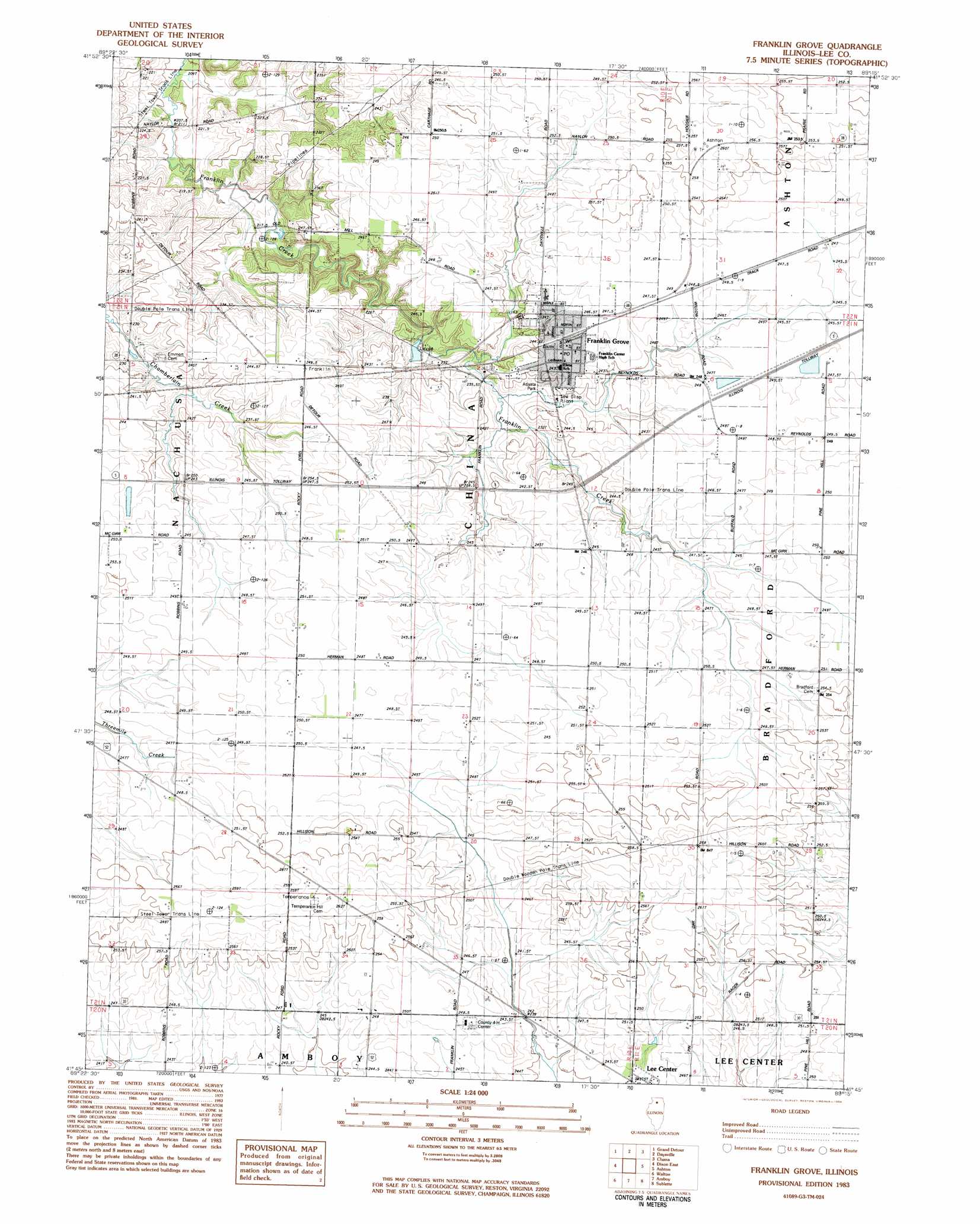
Franklin Grove Topo Map Illinois
To zoom in, hover over the map of Franklin Grove
USGS Topo Quad 41089g3 - 1:24,000 scale
| Topo Map Name: | Franklin Grove |
| USGS Topo Quad ID: | 41089g3 |
| Print Size: | ca. 21 1/4" wide x 27" high |
| Southeast Coordinates: | 41.75° N latitude / 89.25° W longitude |
| Map Center Coordinates: | 41.8125° N latitude / 89.3125° W longitude |
| U.S. State: | IL |
| Filename: | o41089g3.jpg |
| Download Map JPG Image: | Franklin Grove topo map 1:24,000 scale |
| Map Type: | Topographic |
| Topo Series: | 7.5´ |
| Map Scale: | 1:24,000 |
| Source of Map Images: | United States Geological Survey (USGS) |
| Alternate Map Versions: |
Franklin Grove IL 2012 Download PDF Buy paper map Franklin Grove IL 2015 Download PDF Buy paper map |
1:24,000 Topo Quads surrounding Franklin Grove
Forreston South |
Mount Morris |
Oregon |
Stillman Valley |
Kings |
Polo |
Grand Detour |
Daysville |
Chana |
Rochelle |
Dixon West |
Dixon East |
Franklin Grove |
Ashton |
Steward |
Harmon |
Walton |
Amboy |
Sublette |
Compton |
Walnut |
Ohio |
Lamoille |
Mendota West |
Mendota East |
> Back to 41089e1 at 1:100,000 scale
> Back to 41088a1 at 1:250,000 scale
> Back to U.S. Topo Maps home
Franklin Grove topo map: Gazetteer
Franklin Grove: Airports
Gittleson Farms Airport elevation 250m 820′Franklin Grove: Bridges
Mondays Bridge elevation 210m 688′Sundays Bridge elevation 213m 698′
Franklin Grove: Parks
Atlasta Park elevation 235m 770′Franklin Creek Nature Preserve elevation 240m 787′
Franklin Creek State Park elevation 218m 715′
Mill Springs Day Use Area elevation 215m 705′
Temperance Hill Cemetery Prairie Nature Preserve elevation 264m 866′
Franklin Grove: Populated Places
Franklin Grove elevation 245m 803′Franklin Grove: Post Offices
Franklin Grove Post Office elevation 245m 803′Franklin Grove digital topo map on disk
Buy this Franklin Grove topo map showing relief, roads, GPS coordinates and other geographical features, as a high-resolution digital map file on DVD:
Northern Illinois, Northern Indiana & Southwestern Michigan
Buy digital topo maps: Northern Illinois, Northern Indiana & Southwestern Michigan