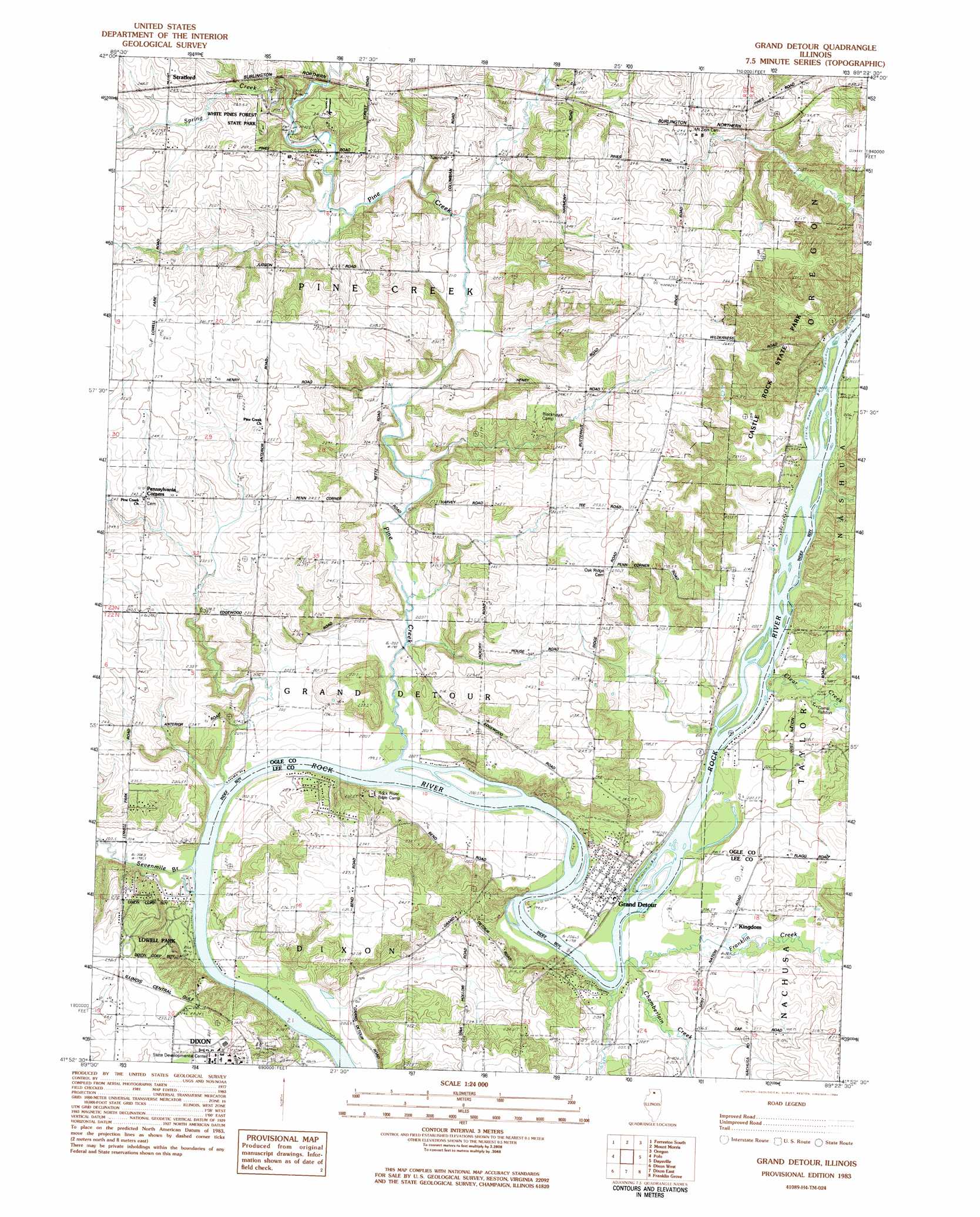
Grand Detour Topo Map Illinois
To zoom in, hover over the map of Grand Detour
USGS Topo Quad 41089h4 - 1:24,000 scale
| Topo Map Name: | Grand Detour |
| USGS Topo Quad ID: | 41089h4 |
| Print Size: | ca. 21 1/4" wide x 27" high |
| Southeast Coordinates: | 41.875° N latitude / 89.375° W longitude |
| Map Center Coordinates: | 41.9375° N latitude / 89.4375° W longitude |
| U.S. State: | IL |
| Filename: | o41089h4.jpg |
| Download Map JPG Image: | Grand Detour topo map 1:24,000 scale |
| Map Type: | Topographic |
| Topo Series: | 7.5´ |
| Map Scale: | 1:24,000 |
| Source of Map Images: | United States Geological Survey (USGS) |
| Alternate Map Versions: |
Grand Detour IL 1983, updated 1984 Download PDF Buy paper map Grand Detour IL 2012 Download PDF Buy paper map Grand Detour IL 2015 Download PDF Buy paper map |
1:24,000 Topo Quads surrounding Grand Detour
Shannon |
Forreston North |
German Valley |
Seward |
Kishwaukee |
Brookville |
Forreston South |
Mount Morris |
Oregon |
Stillman Valley |
Hazelhurst |
Polo |
Grand Detour |
Daysville |
Chana |
Sterling |
Dixon West |
Dixon East |
Franklin Grove |
Ashton |
Hahnaman |
Harmon |
Walton |
Amboy |
Sublette |
> Back to 41089e1 at 1:100,000 scale
> Back to 41088a1 at 1:250,000 scale
> Back to U.S. Topo Maps home
Grand Detour topo map: Gazetteer
Grand Detour: Mines
Pine Creek Quarry elevation 221m 725′Grand Detour: Parks
George B Fell Nature Preserve elevation 259m 849′Lowell Park elevation 221m 725′
White Pines Forest Nature Preserve elevation 240m 787′
White Pines Forest State Park elevation 220m 721′
Grand Detour: Populated Places
Grand Detour elevation 200m 656′Kingdom elevation 204m 669′
Stratford elevation 252m 826′
Grand Detour: Streams
Chamberlain Creek elevation 202m 662′Clear Creek elevation 201m 659′
Franklin Creek elevation 201m 659′
Pine Creek elevation 198m 649′
Sevenmile Branch elevation 197m 646′
Grand Detour: Woods
The Pines elevation 247m 810′Grand Detour digital topo map on disk
Buy this Grand Detour topo map showing relief, roads, GPS coordinates and other geographical features, as a high-resolution digital map file on DVD:
Northern Illinois, Northern Indiana & Southwestern Michigan
Buy digital topo maps: Northern Illinois, Northern Indiana & Southwestern Michigan