Milan Topo Map Illinois
To zoom in, hover over the map of Milan
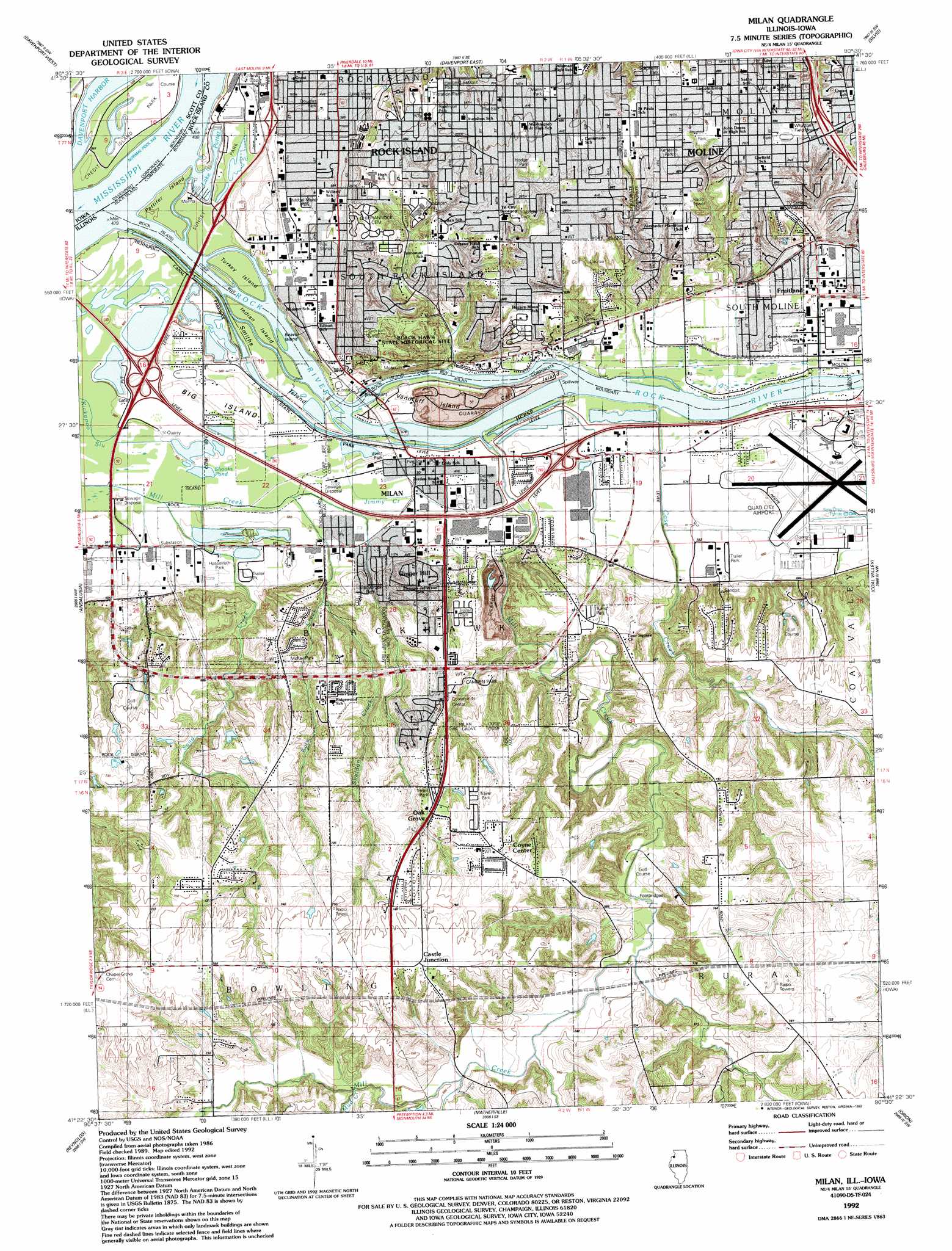
USGS Topo Quad 41090d5 - 1:24,000 scale
| Topo Map Name: | Milan |
| USGS Topo Quad ID: | 41090d5 |
| Print Size: | ca. 21 1/4" wide x 27" high |
| Southeast Coordinates: | 41.375° N latitude / 90.5° W longitude |
| Map Center Coordinates: | 41.4375° N latitude / 90.5625° W longitude |
| U.S. States: | IL, IA |
| Filename: | o41090d5.jpg |
| Download Map JPG Image: | Milan topo map 1:24,000 scale |
| Map Type: | Topographic |
| Topo Series: | 7.5´ |
| Map Scale: | 1:24,000 |
| Source of Map Images: | United States Geological Survey (USGS) |
| Alternate Map Versions: |
Milan IL 1948, updated 1955 Download PDF Buy paper map Milan IL 1950 Download PDF Buy paper map Milan IL 1953, updated 1956 Download PDF Buy paper map Milan IL 1953, updated 1971 Download PDF Buy paper map Milan IL 1953, updated 1976 Download PDF Buy paper map Milan IL 1992, updated 1992 Download PDF Buy paper map Milan IL 2000, updated 2001 Download PDF Buy paper map Milan IL 2012 Download PDF Buy paper map Milan IL 2012 Download PDF Buy paper map Milan IL 2015 Download PDF Buy paper map |
1:24,000 Topo Quads surrounding Milan
Dixon |
Donahue |
Eldridge |
Mccausland |
Cordova |
Walcott |
Davenport West |
Davenport East |
Silvis |
Port Byron |
Montpelier |
Andalusia |
Milan |
Coal Valley |
Green Rock |
Buffalo Prairie |
Reynolds |
Matherville |
Orion |
Andover |
Aledo West |
Aledo East |
Viola |
New Windsor |
Woodhull |
> Back to 41090a1 at 1:100,000 scale
> Back to 41090a1 at 1:250,000 scale
> Back to U.S. Topo Maps home
Milan topo map: Gazetteer
Milan: Airports
Franciscan Heliport elevation 205m 672′Quad-City Airport elevation 177m 580′
Milan: Bays
Davenport Harbor elevation 168m 551′Milan: Crossings
Interchange 11 elevation 173m 567′Interchange 15 elevation 177m 580′
Interchange 3 elevation 206m 675′
Milan: Dams
Lock Number 30 (historical) elevation 168m 551′Lock Number 31 (historical) elevation 168m 551′
Lock Number 32 (historical) elevation 170m 557′
Milan: Islands
Beaver Island elevation 169m 554′Big Island elevation 172m 564′
Carr Island elevation 183m 600′
Credit Island elevation 169m 554′
Indian Island elevation 169m 554′
Pettifer Island elevation 169m 554′
Smiths Island elevation 169m 554′
Turkey Island elevation 169m 554′
Vandruff Island elevation 119m 390′
Milan: Lakes
Lake Potter elevation 169m 554′Shooks Pond elevation 168m 551′
Milan: Mines
Milan Quarry elevation 173m 567′Milan: Parks
Black Hawk Forest Nature Preserve elevation 186m 610′Black Hawk State Historical Site elevation 196m 643′
Browning Field elevation 210m 688′
Camden Park elevation 195m 639′
Collinson Park elevation 184m 603′
Credit Island Park elevation 168m 551′
Dickson Park elevation 172m 564′
Douglas Park elevation 177m 580′
First Presbyterian Park elevation 202m 662′
Hasselroth Park elevation 174m 570′
Hauberg Estates Park elevation 210m 688′
Hodge Park elevation 211m 692′
Indian Bluff Forest Preserve elevation 207m 679′
Karstens Park elevation 210m 688′
Kiwanis Park elevation 207m 679′
Longview Park elevation 200m 656′
McKay Park elevation 189m 620′
Mel Hodge Park elevation 210m 688′
Model Manor Park elevation 179m 587′
Old Horace Mann Park elevation 211m 692′
Optimist Park elevation 211m 692′
Prospect Park elevation 200m 656′
Reservoir Park elevation 213m 698′
Shadybrook Park elevation 184m 603′
Smiths Park elevation 169m 554′
Stephens Park elevation 209m 685′
Sunset Park elevation 171m 561′
Thirty-First Avenue Park elevation 169m 554′
West Park elevation 170m 557′
Milan: Populated Places
Bridgeway Addition elevation 175m 574′Castle Junction elevation 230m 754′
Coyne Center elevation 228m 748′
Fruitland elevation 177m 580′
Ginger Hill elevation 194m 636′
Milan elevation 171m 561′
Oak Grove elevation 220m 721′
Milan: Post Offices
Milan Post Office elevation 171m 561′Milan: Streams
Case Creek elevation 168m 551′Jimmy Creek elevation 171m 561′
Kyte Creek elevation 169m 554′
Mill Creek elevation 168m 551′
Mud Creek elevation 198m 649′
Rock River elevation 168m 551′
Sand Creek elevation 170m 557′
Sheldon Creek elevation 179m 587′
Milan digital topo map on disk
Buy this Milan topo map showing relief, roads, GPS coordinates and other geographical features, as a high-resolution digital map file on DVD: