Cordova Topo Map Illinois
To zoom in, hover over the map of Cordova
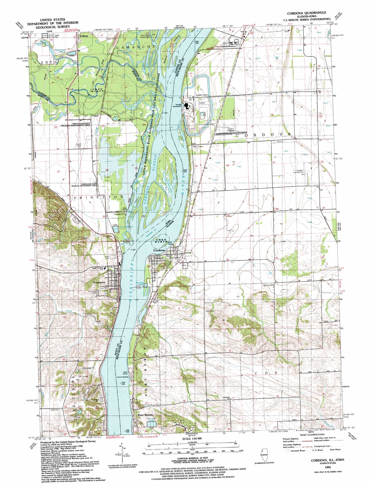
USGS Topo Quad 41090f3 - 1:24,000 scale
| Topo Map Name: | Cordova |
| USGS Topo Quad ID: | 41090f3 |
| Print Size: | ca. 21 1/4" wide x 27" high |
| Southeast Coordinates: | 41.625° N latitude / 90.25° W longitude |
| Map Center Coordinates: | 41.6875° N latitude / 90.3125° W longitude |
| U.S. States: | IL, IA |
| Filename: | o41090f3.jpg |
| Download Map JPG Image: | Cordova topo map 1:24,000 scale |
| Map Type: | Topographic |
| Topo Series: | 7.5´ |
| Map Scale: | 1:24,000 |
| Source of Map Images: | United States Geological Survey (USGS) |
| Alternate Map Versions: |
Cordova IL 1952, updated 1953 Download PDF Buy paper map Cordova IL 1953, updated 1957 Download PDF Buy paper map Cordova IL 1953, updated 1971 Download PDF Buy paper map Cordova IL 1953, updated 1977 Download PDF Buy paper map Cordova IL 1991, updated 1992 Download PDF Buy paper map Cordova IL 2010 Download PDF Buy paper map Cordova IL 2012 Download PDF Buy paper map Cordova IL 2015 Download PDF Buy paper map |
1:24,000 Topo Quads surrounding Cordova
Delmar South |
Goose Lake |
Andover |
Clinton Nw |
Thomson |
De Witt |
Malone |
Camanche |
Clinton |
Union Grove |
Eldridge |
Mccausland |
Cordova |
Erie Nw |
Erie |
Davenport East |
Silvis |
Port Byron |
Hillsdale |
Spring Hill |
Milan |
Coal Valley |
Green Rock |
Geneseo |
Atkinson |
> Back to 41090e1 at 1:100,000 scale
> Back to 41090a1 at 1:250,000 scale
> Back to U.S. Topo Maps home
Cordova topo map: Gazetteer
Cordova: Airports
The Sandbox Airport elevation 184m 603′Cordova: Areas
Princeton State Wildlife Management Area elevation 176m 577′Cordova: Islands
Adams Island elevation 176m 577′Adams Island elevation 176m 577′
Cordova: Mines
Shaffton Quarry elevation 168m 551′Cordova: Parks
Ben Martinsen Area elevation 177m 580′Hagenson Pond Area elevation 178m 583′
Old School Park elevation 186m 610′
Water Tower Park elevation 212m 695′
Cordova: Populated Places
Cordova elevation 179m 587′Folletts elevation 184m 603′
Princeton elevation 179m 587′
Rivercrest Estates elevation 189m 620′
Cordova: Post Offices
Princeton Post Office elevation 183m 600′Cordova: Reservoirs
Hagenson Pond elevation 177m 580′Cordova: Streams
Bud Creek elevation 175m 574′Cordova Slough elevation 175m 574′
Lost Creek elevation 177m 580′
Lund Creek elevation 175m 574′
Schricker Slough elevation 176m 577′
Sodus Creek elevation 176m 577′
Wapsipinicon River elevation 175m 574′
Wapsipinicon River elevation 175m 574′
Whiskey Run Creek elevation 175m 574′
Cordova digital topo map on disk
Buy this Cordova topo map showing relief, roads, GPS coordinates and other geographical features, as a high-resolution digital map file on DVD: