Dixon Topo Map Iowa
To zoom in, hover over the map of Dixon
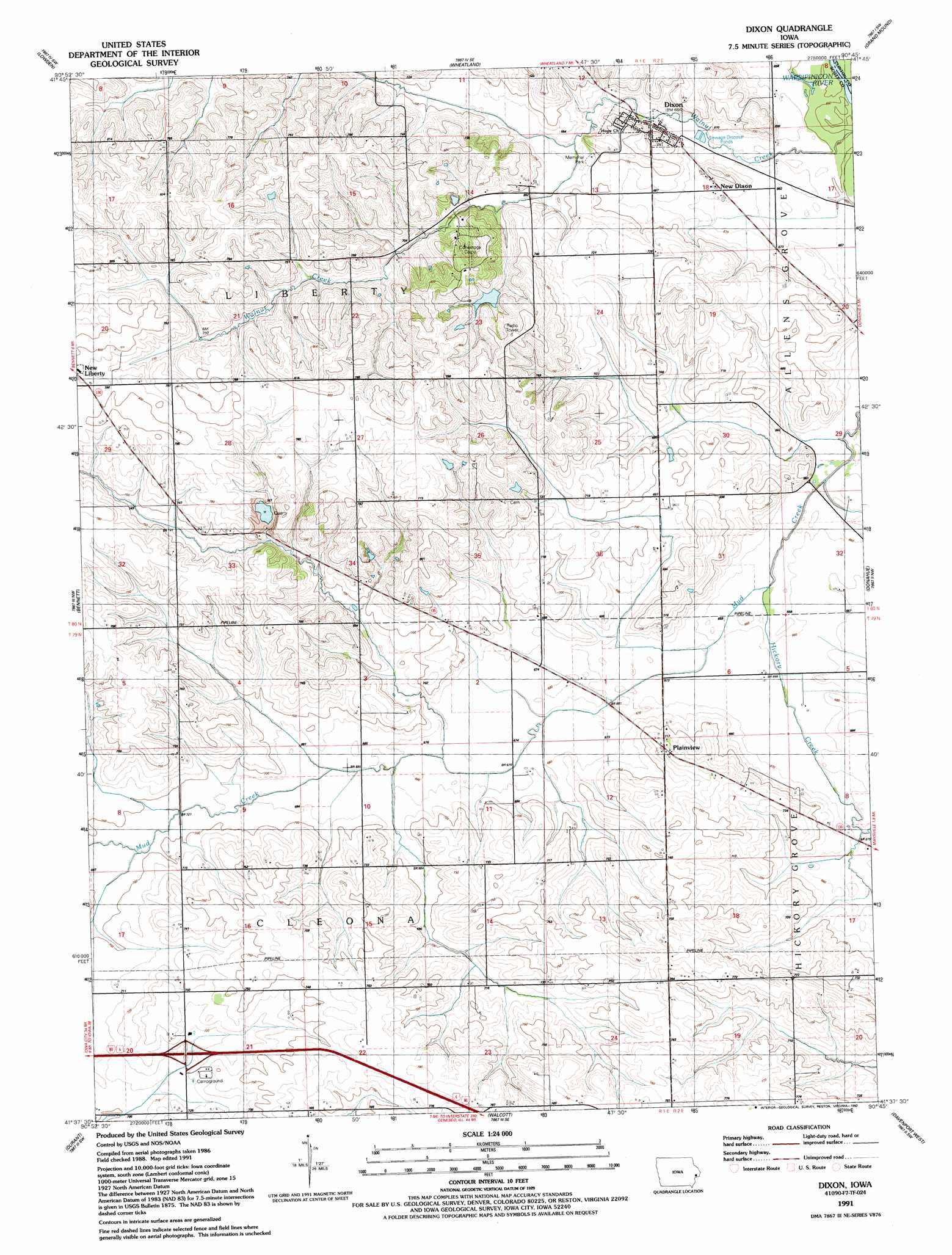
USGS Topo Quad 41090f7 - 1:24,000 scale
| Topo Map Name: | Dixon |
| USGS Topo Quad ID: | 41090f7 |
| Print Size: | ca. 21 1/4" wide x 27" high |
| Southeast Coordinates: | 41.625° N latitude / 90.75° W longitude |
| Map Center Coordinates: | 41.6875° N latitude / 90.8125° W longitude |
| U.S. State: | IA |
| Filename: | o41090f7.jpg |
| Download Map JPG Image: | Dixon topo map 1:24,000 scale |
| Map Type: | Topographic |
| Topo Series: | 7.5´ |
| Map Scale: | 1:24,000 |
| Source of Map Images: | United States Geological Survey (USGS) |
| Alternate Map Versions: |
Dixon IA 1953, updated 1958 Download PDF Buy paper map Dixon IA 1953, updated 1971 Download PDF Buy paper map Dixon IA 1953, updated 1977 Download PDF Buy paper map Dixon IA 1991, updated 1992 Download PDF Buy paper map Dixon IA 2010 Download PDF Buy paper map Dixon IA 2013 Download PDF Buy paper map Dixon IA 2015 Download PDF Buy paper map |
1:24,000 Topo Quads surrounding Dixon
Clarence |
Oxford Junction |
Lost Nation |
Elwood |
Delmar South |
Tipton East |
Lowden |
Wheatland |
Grand Mound |
De Witt |
Lime City |
Bennett |
Dixon |
Donahue |
Eldridge |
Wilton Junction |
Durant |
Walcott |
Davenport West |
Davenport East |
Muscatine |
Illinois City |
Montpelier |
Andalusia |
Milan |
> Back to 41090e1 at 1:100,000 scale
> Back to 41090a1 at 1:250,000 scale
> Back to U.S. Topo Maps home
Dixon topo map: Gazetteer
Dixon: Crossings
Interchange 280 elevation 221m 725′Dixon: Parks
Memorial Park elevation 208m 682′Dixon: Populated Places
Dixon elevation 206m 675′New Dixon elevation 206m 675′
Plainview elevation 223m 731′
Dixon: Post Offices
Dixon Post Office elevation 206m 675′New Hamburgh Post Office (historical) elevation 221m 725′
Plain View Post Office (historical) elevation 228m 748′
Round Grove Post Office (historical) elevation 237m 777′
Dixon: Streams
Hickory Creek elevation 198m 649′Dixon digital topo map on disk
Buy this Dixon topo map showing relief, roads, GPS coordinates and other geographical features, as a high-resolution digital map file on DVD: