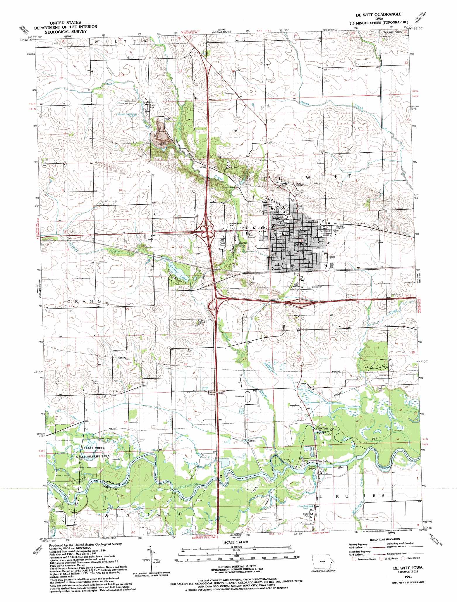
De Witt Topo Map Iowa
To zoom in, hover over the map of De Witt
USGS Topo Quad 41090g5 - 1:24,000 scale
| Topo Map Name: | De Witt |
| USGS Topo Quad ID: | 41090g5 |
| Print Size: | ca. 21 1/4" wide x 27" high |
| Southeast Coordinates: | 41.75° N latitude / 90.5° W longitude |
| Map Center Coordinates: | 41.8125° N latitude / 90.5625° W longitude |
| U.S. State: | IA |
| Filename: | o41090g5.jpg |
| Download Map JPG Image: | De Witt topo map 1:24,000 scale |
| Map Type: | Topographic |
| Topo Series: | 7.5´ |
| Map Scale: | 1:24,000 |
| Source of Map Images: | United States Geological Survey (USGS) |
| Alternate Map Versions: |
De Witt IA 1953, updated 1957 Download PDF Buy paper map De Witt IA 1953, updated 1977 Download PDF Buy paper map De Witt IA 1991, updated 1992 Download PDF Buy paper map De Witt IA 2010 Download PDF Buy paper map De Witt IA 2013 Download PDF Buy paper map De Witt IA 2015 Download PDF Buy paper map |
1:24,000 Topo Quads surrounding De Witt
Baldwin |
Maquoketa |
Delmar North |
Preston |
Miles |
Lost Nation |
Elwood |
Delmar South |
Goose Lake |
Andover |
Wheatland |
Grand Mound |
De Witt |
Malone |
Camanche |
Dixon |
Donahue |
Eldridge |
Mccausland |
Cordova |
Walcott |
Davenport West |
Davenport East |
Silvis |
Port Byron |
> Back to 41090e1 at 1:100,000 scale
> Back to 41090a1 at 1:250,000 scale
> Back to U.S. Topo Maps home
De Witt topo map: Gazetteer
De Witt: Bridges
Ames Creek Bridge elevation 204m 669′De Witt: Lakes
Crystal Lake elevation 199m 652′De Witt: Mines
Behr Quarry elevation 198m 649′De Witt: Parks
Barber Creek State Wildlife Management Area elevation 190m 623′John Letter Historical Marker elevation 235m 770′
Lincoln Park elevation 219m 718′
West Brook Park elevation 201m 659′
De Witt: Populated Places
Country Estates Mobile Home Park elevation 188m 616′De Witt elevation 216m 708′
Gambrill (historical) elevation 190m 623′
Noel (historical) elevation 192m 629′
De Witt: Post Offices
De Witt Post Office elevation 218m 715′Gambril Post Office (historical) elevation 190m 623′
Noel Post Office (historical) elevation 192m 629′
De Witt: Streams
Barber Creek elevation 189m 620′Crystal Creek elevation 195m 639′
Mason Creek elevation 192m 629′
McDonald Creek elevation 183m 600′
Rock Creek elevation 198m 649′
Silver Creek elevation 186m 610′
De Witt digital topo map on disk
Buy this De Witt topo map showing relief, roads, GPS coordinates and other geographical features, as a high-resolution digital map file on DVD: